
Lunar Orbiter Image Recovery Project (LOIRP) Releases New High Resolution Image of The Apollo 14 Landing Site With EVA Details
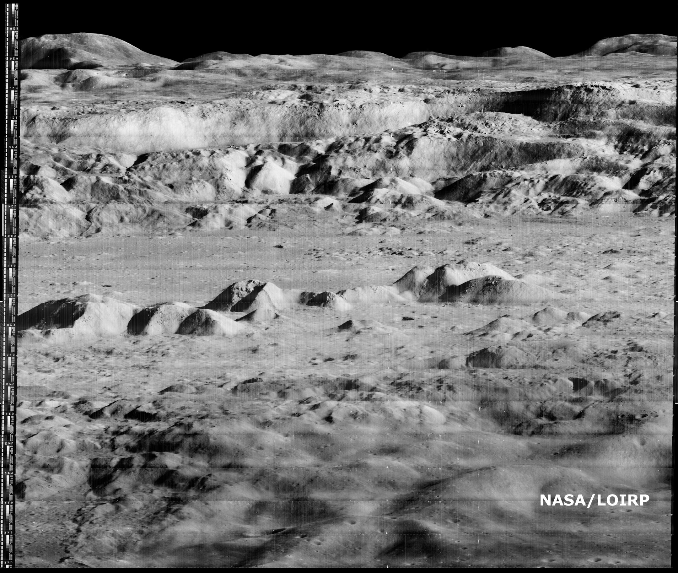
This photo (Frame 133-H2) of the future Apollo 14 landing site was taken by Lunar Orbiter III on 20 February 1967 at an orbital altitude of 46.7 km. The resolution of the image is around 0.8 meters per pixel. The area covered by this image is 4.52167 x 5.77666 km.
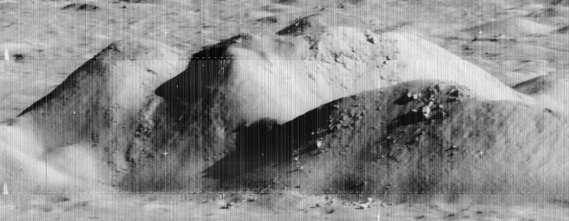
Figure 1 shows the image unlabeled. In Figure 2 we have overlaid the EVA route upon this image so as to show where the crew set foot. While the crew were supposed to visit Cone crater they stopped 20 meters short of doing so due to some confusion as to their exact location. That said, they did visit some large rocks located adjacent to Cone crater’s rim. The enlargement of this Lunar Orbiter image clearly shows some large rocks poised near the crater’s rim. The inset photo shows the largest outcropping as photographed by the crew on the surface.
NOTE: We originally posted these files in an incorrect orientation. This was due to how the images originally show up when they are retrieved from the original tapes. Thanks to all of you eagle-eyed viewers we caught that. We have replaced those earlier files with ones that are correctly oriented to North, South, East, and West.
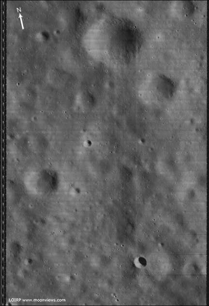
Figure 1 Lunar Orbiter III Frame 133-H2 unlabeled [larger view]
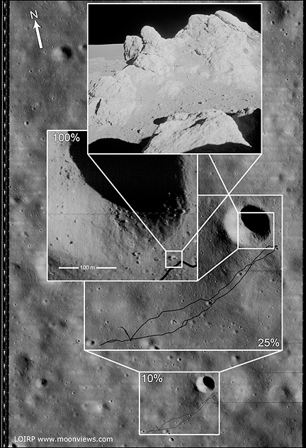
Figure 2 Lunar Orbiter III Frame 133-H2 labeled to show EVA route. [larger view]
This image has been recovered in its original high resolution format from original Lunar Orbiter project data tapes using restored tape drive hardware and will eventually be submitted to the PDS (Planetary Data System). The full resolution is online here at NLSI.
LOIRP Note: We will be putting the full resolution version of this image on the NASA Lunar Science Institute website with the layers preserved for Photoshop for all you folks to have fun with! We only ask that you send us copies of what you do and credit us if you publish it anywhere.
For more information on the Lunar Orbiter Image Recovery Project (LOIRP) visit https://moonviews.wpenginepowered.com
For information on NASA’s Lunar Science Institute visit http://lunarscience.arc.nasa.gov/
Related Links
Apollo 14 Surface Operations Overview
Apollo 14 Preliminary Science Report
Apollo 14 Mission Report
Apollo 14 Lunar Surface Journal
Lunar Orbiter Image Recovery Project (LOIRP) Releases New High Resolution Image of the Ocean of Storms
Larger version
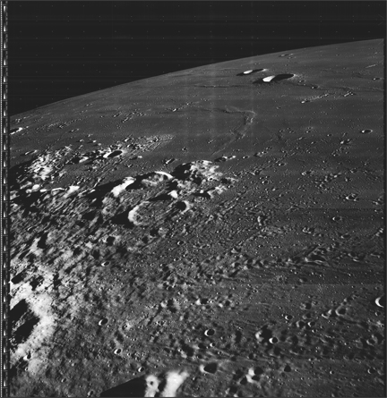
The Lunar Orbiter Image Recovery Project (LOIRP) has released a newly-retrieved, high resolution image taken of the lunar surface 42 years ago.
This image was taken by Lunar Orbiter III (LPI data) in February 1967. This oblique photo shows the region around the crater Galilaei and Planitia Descensus in Oceanus Procellarum (the Sea of Storms). In the upper center of the image you can see the Great Wall of Procellarum.
This image has been recovered in its original high resolution format from original Lunar Orbiter project data tapes using restored tape drive hardware and will eventually be submitted to the PDS (Planetary Data System).
LOIRP Note: We will be putting the full resolution version of this image on the NASA Lunar Science Institute website with the layers preserved for Photoshop for all you folks to have fun with! We only ask that you send us copies of what you do and credit us if you publish it anywhere.
For more information on the Lunar Orbiter Image Recovery Project (LOIRP) visit https://moonviews.wpenginepowered.com
For information on NASA’s Lunar Science Institute visit http://lunarscience.arc.nasa.gov/
Apple WWDC Lunchtime Session: Dennis Wingo of the Lunar Orbiter Image Recovery Project (LOIRP)
 Thursday 12 June 2009: noon: Come hear Dennis Wingo of the Lunar Orbiter Image Recovery Project (LOIRP) discuss their use of Mac OS X technology to save our Space Race heritage. LOIRP is retrieving, digitizing and publishing high-resolution pictures of the Moon captured by five NASA space probes ahead of the Apollo 11 moon landings in 1969. These tapes – rescued from destruction by a determined NASA archivist – represent some of the highest-resolution pictures ever taken of the Moon’s surface and are a priceless piece of history.
More info at http://developer.apple.com/wwdc/sciencemedicine/
LOIRP Releases Lunar Orbiter Ranger 8 Impact Crater Image
The Lunar Orbiter II-070-H image (Frame 70, High resolution) has a unique feature that is relevant to the LCROSS mission. This image shows the impact site of the Ranger 8 mission. This location was identified decades ago and is discussed in the NASA SP-168 online address. This location was also photographed during the Apollo 16 mission (NASA SP-315 page 29-46) but at a lower resolution of 3-5 meters. The image was taken from an altitude of 45.81 km. The resolution is about 0.4 meters per pixel. The crater from the Ranger impact is not well defined in the existing film database, especially as it appears at the boundary between two framelets.
Figure 1 is the reproduced trajectory of the Ranger 8 mission from NASA SP-168:

Figure 1: Ranger 8 Impact Trajectory Overlay on LOII-070-H (NASA SP-168). Image credit: LOIRP
Click on image to enlarge
Figure 2 shows the detail of the projected impact point:

Figure 2: Ranger 8 Estimated Impact Point (Crater C1). Image credit: LOIRP. Click on image to enlarge
The scale of an entire framelet is ~200 meters. While the full framelet is not shown here, the ragged overlap between two framelets from the film version of the image has lead to a misleading conclusion regarding the size and the shape of the crater. Crater C1 was disputed as the location of the impact in another NASA document (SP-315). The Apollo 16 preliminary science report (SP-315) identifies crater C2 as the impact point of Ranger 8 because it is consistent with other craters photographed by the later Apollo missions. The central mound is a distinctive signature of these impacts. Figure 3 is a low resolution version of our updated image from the LOIRP scans. The full resolution image [2.9 GB tiff] can be downloaded here

Figure 3: LOIRP LOII-70-H Image (reduced resolution). Image credit: LOIRP. Click on image to enlarge
Figure 4 shows the enhanced detail available from the LOIRP analog data tapes. Since the contrast is muted due to the nature of the site, the dynamic range improvements are not as noticeable. In the digital domain the framelet edges can be repositioned to generate a super-resolution version of the image by scanning the tape multiple times. The central mound, which seems to be an indicator of these small craters (as discussed in NASA SP 315 for the SIV-B impacts) is clearly evident here. The dark surrounding ejecta blanket was not expected, which drove the early identification of crater C1 as the impact point. However, it is unclear if the light colored ejecta to the lower left is associated with crater C1 or C2.

Figure 4: Detail of LOII-070-H2-f-601-602. Image credit: LOIRP. Click on image to enlarge
From a science perspective we are able to discern the size of the crater to a precise number (12.5 meters), which can give the LCROSS team a ground truth for similarly sized spacecraft.
Posted by: Soderman/NLSI Staff Source: D. Wingo/ LOIRP
LCROSS Citizen Science

The Lunar Crater Observation and Sensing Satellite (LCROSS) will excavate the permanently dark floor of one of the Moon’s polar craters with two heavy impactors in 2009 to test the theory that ancient ice lies buried there. The impact will eject material from the crater’s surface and subsurface to create a plume that specialized instruments will be able to analyze for the presence of water (ice and vapor), hydrocarbons and hydrated materials. Mission scientists estimate that the Centaur impact plume may be visible through amateur-class telescopes with apertures as small as 10 to 12 inches. As the mission progresses, this site will provide the general public, classrooms, and the amateur astronomy community details on how to observe the impact. The LCROSS mission will actively solicit images of the impact from the public. These images will provide a valuable addition to the archive of data chronicling the impact and its aftermath. This site will include a gallery of images received from both the public and professional communities. [More]
House of Representatives Honors Lunar Orbiter Image Recovery Project
HONORING THE LUNAR ORBITER IMAGE RECOVERY PROJECT
HON. ZOE LOFGREN
OF CALIFORNIA
IN THE HOUSE OF REPRESENTATIVES
Monday, April 27, 2009
Ms. ZOE LOFGREN of California. Madam Speaker, I rise to commend the Lunar Orbiter Image Recovery Project and all those who have contributed their time and effort to ensure that historic images and vital data from the Lunar Orbiter missions of the 1960s are not lost to future generations.
In 1965, Charles Byrne, an engineer with Bellcomm, Inc., had the foresight to propose that NASA record data from the Lunar Orbiter missions onto tape recorders. NASA agreed and the images returned from the Lunar Orbiters were backed up on AMPEX FR-900 tape drives. To date, these images are some of highest resolution images we have of the Moon. Those images include a high-resolution version of “Earthrise,” the first picture of the Earth from the Moon’s vantage point. Time Magazine has called this image “the photo of the century.” The tapes also contain the first stereo imagery of the Moon’s surface. Indeed, these are some of the best images of the Moon ever taken, far superior from those received from the Hubble telescope.
Continue reading “House of Representatives Honors Lunar Orbiter Image Recovery Project”
Like None Other – Restored Moon Images to Help Future Moon Missions
First Moon Images No Longer Lost in Space, AP
“Mankind’s first up-close photos of the lunar landscape have been rescued from four decades of dusty storage. As AP’s Haven Daley reports, they’ve been restored to such a high quality that they rival anything taken by modern cameras.”
KTVU: Old NASA Tapes Reveal Stunning New Moon Images; Resolution Unparalleled
Old NASA Tapes Reveal Stunning New Moon Images; Resolution Unparalleled
KTVU looked at several images, and the detail and clarity are astonishing. It’s the difference between grainy 35mm film with several generations of degradation, and the 70mm film original.
“Dennis Wingo brought up NASA’s publicly released photo from August 23, 1966, called “Earthrise.” Time Magazine called it the “Photo of the Century” and it is certainly amazing even today. But on the next screen Wingo showed the digitized version from the original tracking station tapes. Zooming in on the first version, Earth looks a bit fuzzy, though you can make out cloud patterns. On the recovered version, you can see fog along the Chilean coast, ice floes near the Antarctic. It is truly astonishing.
“Using these and some other 1966 images, we may be able to help push NASA’s climate data back in time a full decade, which will help with climate change studies,” says Wingo.
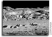
On shots of the lunar surface, the first versions show a blurry shadow here, some grayish along the horizon. The digitized recovered image is crisp with the deep black of space hovering over a multi-shaded gray surface, almost as if you were looking out the window of some lunar highrise. You can see rocks the size of an office chair. Sharp shadows and almost a 3D effect.”
Full story and Video at KTVU
LOIRP in the News
Old Moon Images Get Modern Makeover, Fox
Old Moon Images Get Modern Makeover, LiveScience
“Dennis Wingo, LOIRP’s team leader, detailed the group’s work in progress during last week’s 40th Lunar and Planetary Science Conference. Teamed with SpaceRef.com, LOIRP’s saga is one of acquiring the last surviving Ampex FR-900 machinery that can play analog image data from the Lunar Orbiter spacecraft. Wingo noted that the work is backed by NASA’s Exploration Systems Mission Directorate, the space agency’s Innovative Partnership Program, along with private organizations, making it possible to overhaul old equipment, digitally upgrade and clean-up the imagery via software. LOIRP is located at NASA’s Ames Research Center at Moffett Field, Calif. There, project members are taking the analog data, converting it into digital form and reconstructing the images. By moving them into the digital domain, Wingo said, the photos now offer a higher dynamic range and resolution than the original pictures, he added. “We’re going to be releasing these to the whole world,” Wingo said. Use of the refreshed images, contrasted to what NASA’s upcoming Lunar Reconnaissance Orbiter (LRO) mission is slated to produce, has an immediate scientific benefit. That is, what is the frequency of impacts on the Moon’s already substantially crater-pocked surface? “We’ll be able to get crater counts,” Wingo told SPACE.com. “LRO imagery of the same terrain imaged decades ago will provide a crater count over the last 40 years.”
Restoring History
 NASA’s early lunar images, in a new light, Los Angeles Times
“Rising over the battered surface of the moon, Earth loomed in a shimmering arc covered in a swirling skin of clouds. The image, taken in 1966 by NASA’s robotic probe Lunar Orbiter 1, presented a stunning juxtaposition of planet and moon that no earthling had ever seen before. It was dubbed the Picture of the Century. “The most beautiful thing I’d ever seen,” remembered Keith Cowing, who saw it as an 11-year-old and credited it with eventually luring him to work for NASA. But in the mad rush of discovery, even the breathtaking can get mislaid. But in the mad rush of discovery, even the breathtaking can get mislaid. NASA was so preoccupied with getting an astronaut to the moon ahead of the Soviets that little attention was paid to the mountains of scientific data that flowed back to Earth from its early space missions. The data, stored on miles of fragile tapes, grew into mountains that were packed up and sent to a government warehouse with crates of other stuff. And so they eventually came to the attention of Nancy Evans, a no-nonsense woman with flaming red hair that fit her sometimes-impatient nature.”
Newly Restored “Picture of the Century”: Lunar Orbiter 2’s View of Copernicus
 The Lunar Orbiter Image Recovery Project (LOIRP) has released another iconic image taken during the Lunar Orbiter program in the 1960’s. This image, which shows the dramatic landscape within the crater Copernicus was often referred to as the “picture of the century” by many people at the time of its original public release in 1966.
This image was taken by the Lunar Orbiter 2 spacecraft at 7:05 p.m. EST on 24 November 1966 from an altitude of 28.4 miles above the lunar surface, 150 miles due south of Copernicus. At the time this image was originally released most views of the lunar surface involved looking straight down. Little, if any, sense of the true elevation of lunar surface features was usually available. This photo changed that perception by showing the Moon to be a world with tremendous topography – some of it Earth-like, much of it decidedly un-earth-like.
According to Wikipedia: “In 1966 the crater was photographed from an oblique angle by Lunar Orbiter 2 as one of 12 “housekeeping” pictures that were taken to advance the roll of film between possible astronaut landing sites being surveyed. At the time this detailed image of the lunar surface was termed by NASA Scientist Martin Swetnick and subsequently quoted by Time magazine as “one of the great pictures of the century.”
Time magazine said (“A New Look at Copernicus“): “Except for the black sky in the background, the photograph might have been mistaken for a composite of the scenic grandeur of Grand Canyon and the barren desolation of the Badlands of South Dakota. But when it was flashed unexpectedly onto a screen at a meeting of the American Institute of Aeronautics and Astronautics in Boston last week, sophisticated space scientists and engineers recognized the terrain immediately. It was a spectacular close up shot of lunar landscape. That photograph of the moon’s Crater of Copernicus, said NASA Scientist Martin Swetnick, is “one of the great pictures of the century.”
The following image is an interim version, with reprocessing and enhancements being made constantly. A larger, raw version (2.2 GB in size) is now online at NASA’s Lunar Science Institute. Larger view.
If you compare this new image with LPI’s high res version you can clearly see that this new image shows multiple striations in the surface, small boulders, landslides, shadows and a myriad of fine details simply not visible in the original. The LOIRP currently estimates that the resolution of this image is less than 1 meter/pixel. Larger view.
Dennis Wingo, co-lead of the LOIRP will make a presentation on this image and the LOIRP at the Lunar and Planetary Science Conference on Monday, 23 March 2009 at 8:30 am (session 102)
The LOIRP, funded by NASA’s Exploration Mission Systems Directorate and NASA’s Innovative Partnership’s Program, with support from Odyssey Moon, Skycorp Inc., SpaceRef Interactive Inc., ACES, and the NASA Lunar Science Institute, is housed at NASA Ames Research Center at Moffet Field, CA. This project has utilized original analog data tapes and restored tape drives to digitize original Lunar Orbiter project imagery. Utilizing computer technology unavailable at the time the images were originally taken, LOIRP has been able to produce images which greatly exceed the resolution of the images as they were first seen in 1966 and 1967.
The first image released by the LOIRP, the famous “earthrise image”, was made public in November 2008. It is anticipated with the release of this latest image of Copernicus, and further restoration of the original 40 year old hardware, that the pace of additional image releases will now increase.
Further information on the LOIRP can be found at https://moonviews.wpenginepowered.com/
You can follow our image restoration process on Twitter at LunarOrbiter