First Earthrise Photo Taken 48 Years Ago Today

Keith’s note: 48 Years ago today, on 23 August 1966, Lunar Orbiter 1 snapped the first photo of Earth as seen from lunar orbit (Larger view). While a remarkable image at the time, the full resolution of the image was never retrieved from the data stored from the mission. In 2008, this earthrise image was restored by the Lunar Orbiter Image Recovery Project at NASA Ames Research Center. We obtained the original data tapes from the mission (the last surviving set) and restored original FR-900 tape drives to operational condition using both 60s era parts and modern electronics. The following links provide background on the image, its restoration, and reactions to its release.
Here is a comparison of the full image in its original, familiar context (higher res)(print quality). You can download a 1.2 GB version from NASA here. Note: this is a very large file.


Newly Restored Lunar Orbiter Image of Earth and Moon (Detail)
How the Photo Was Taken
House of Representatives Honors Lunar Orbiter Image Recovery Project
Nimbus II and Lunar Orbiter 1 Imagery: A New Look at Earth in 1966
Dumpster Diving for Science, Science Magazine
What Lunar Orbiter 1 Was Seeing on 23 August 1966

Earth Before Earth Day

Long before man journeyed to the moon and looked back at the tiny, fragile planet that houses humanity, remote orbiters were sending back pictures of home.
Sent to scope out potential landing sites on the Moon, the series of five Lunar Orbiters also sent back the earliest views of Earth from another celestial body. This image, taken in 1966 by Lunar Orbiter 1, is among the first views of Earth from the Moon. In the black-and-white image, a crescent Earth floats majestically behind the lumpy surface of the Moon.

Continue reading “Earth Before Earth Day”

The ‘Other’ Lunar Orbiter 1 Earthrise Image


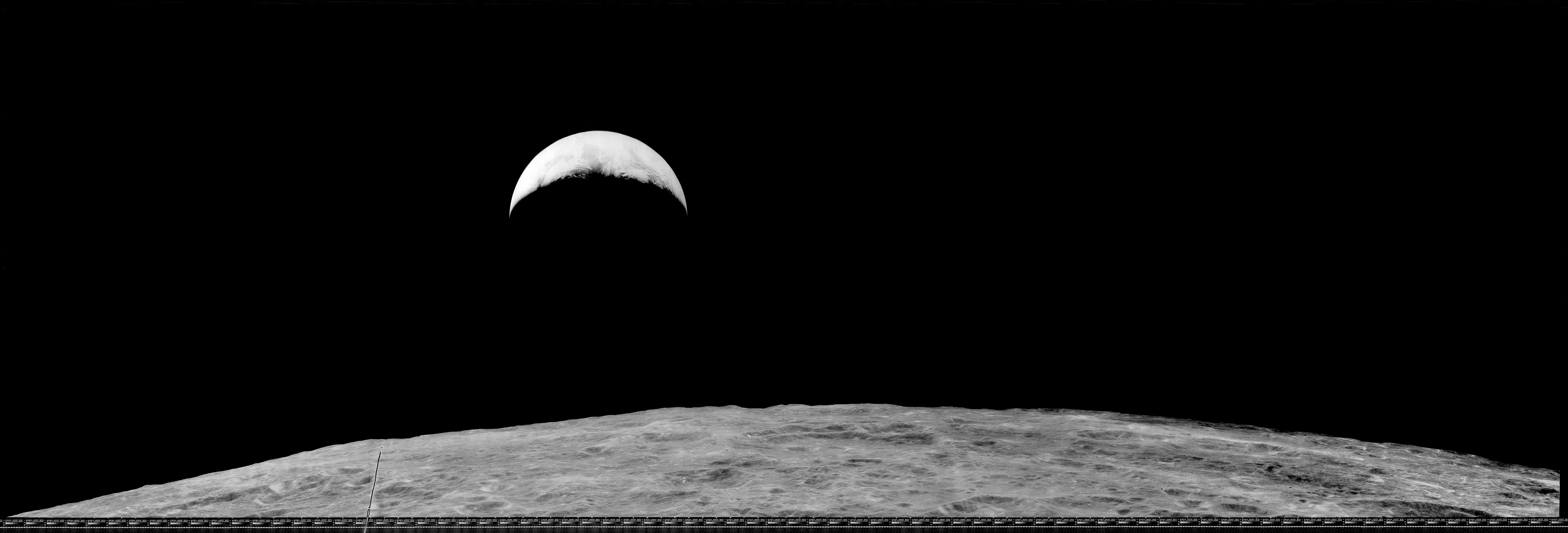
A newly enhanced image of Earth taken from lunar orbit 47 years ago has been released. The image, taken by Lunar Orbiter 1 in 1966, is the latest in a series of images released by the Lunar Orbiter Image Recovery Project (LOIRP).
This image is actually one of a pair of images taken of Earth by Lunar Orbiter 1. Its twin image, taken first, was much more famous and captured the world’s imagination when first released by NASA nearly half a century ago. That “Earthrise” image, as it came to be known, was also the first image re-released by the LOIRP in November 2008.
These two pictures were not included in the original mission plan. Taking these images required that the spacecraft’s attitude in relation to the lunar surface be changed so that the camera’s lenses were pointing away from the Moon. Such maneuvering meant a calculated risk and, coming early in the flight, the unplanned photograph of Earth raised some doubts among Boeing management about the safety of the spacecraft – especially on the very first Lunar Orbiter mission. (see How the Photo Was Taken)


Larger images (various enlargements of 10% of full size image): [medium] [large] [very large] [raw 100% full sized TIFF – approx 1 GB in size – online at NASA soon]
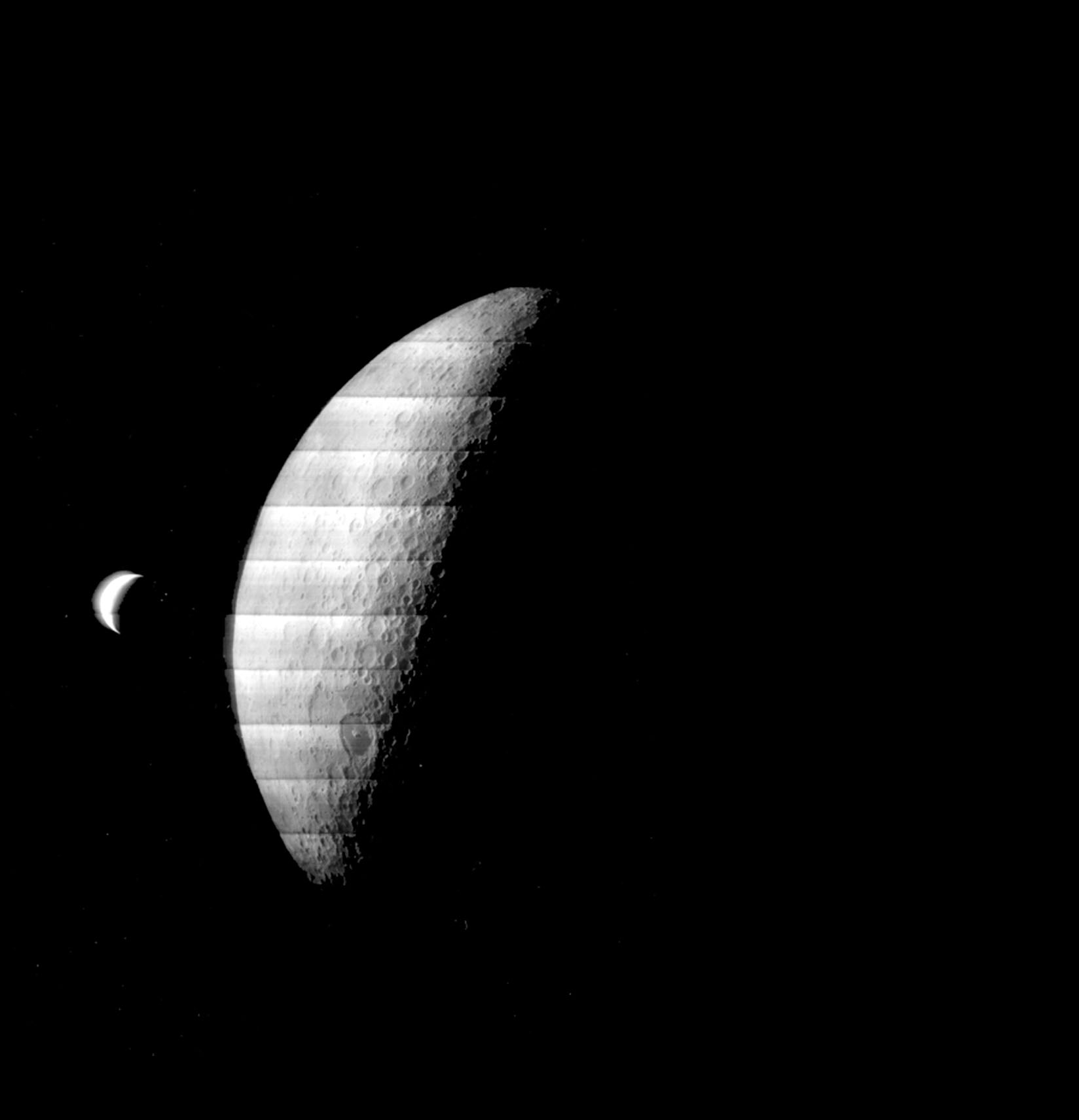
This second earthrise image (Frame 1117) was taken two days after the first image (Frame 1102) on 25 August 1966 at 13:02:05 GMT. As with the earlier earthrise image, you can see a crescent Earth hovering above the limb of the Moon. Most of what you see on the Moon is the farside with the Sea of Tsiolkovsky prominently featured in the medium resolution image. A flaw in the onboard processing of the first image left a large flaw whereas this second image, although it has a similar flaw, is far more uniform in its quality than the first image.
The data chart on the right (larger version) shows time that the two Earth images were taken.
This second earthrise image was taken under circumstances nearly identical to the first earthise image. Indeed the two images look very, very similar. As was the case with virtually all Lunar Orbiter images, this second earthrise always been available to the public albeit in its original, murky, 1966 resolution. But for some reason, this other earthrise never got the same amount of visibility in 1966.
This is not an unusual – the first image was, well, the “first”. This happens a lot. Most people are unaware that Yosemite Valley has a nearby twin, called “Hetch Hetchy”. It is flooded with water nearly a century ago and has served serves as a reservoir, much of its majesty obscured. People used to know about both as equals – but not any more.
The highest resolution versions of Frame 117 previously available are online at the Lunar and Planetary Institute. You can compare Frame 1117 with the earlier Frame 1102 and see that the images are of similar composition.


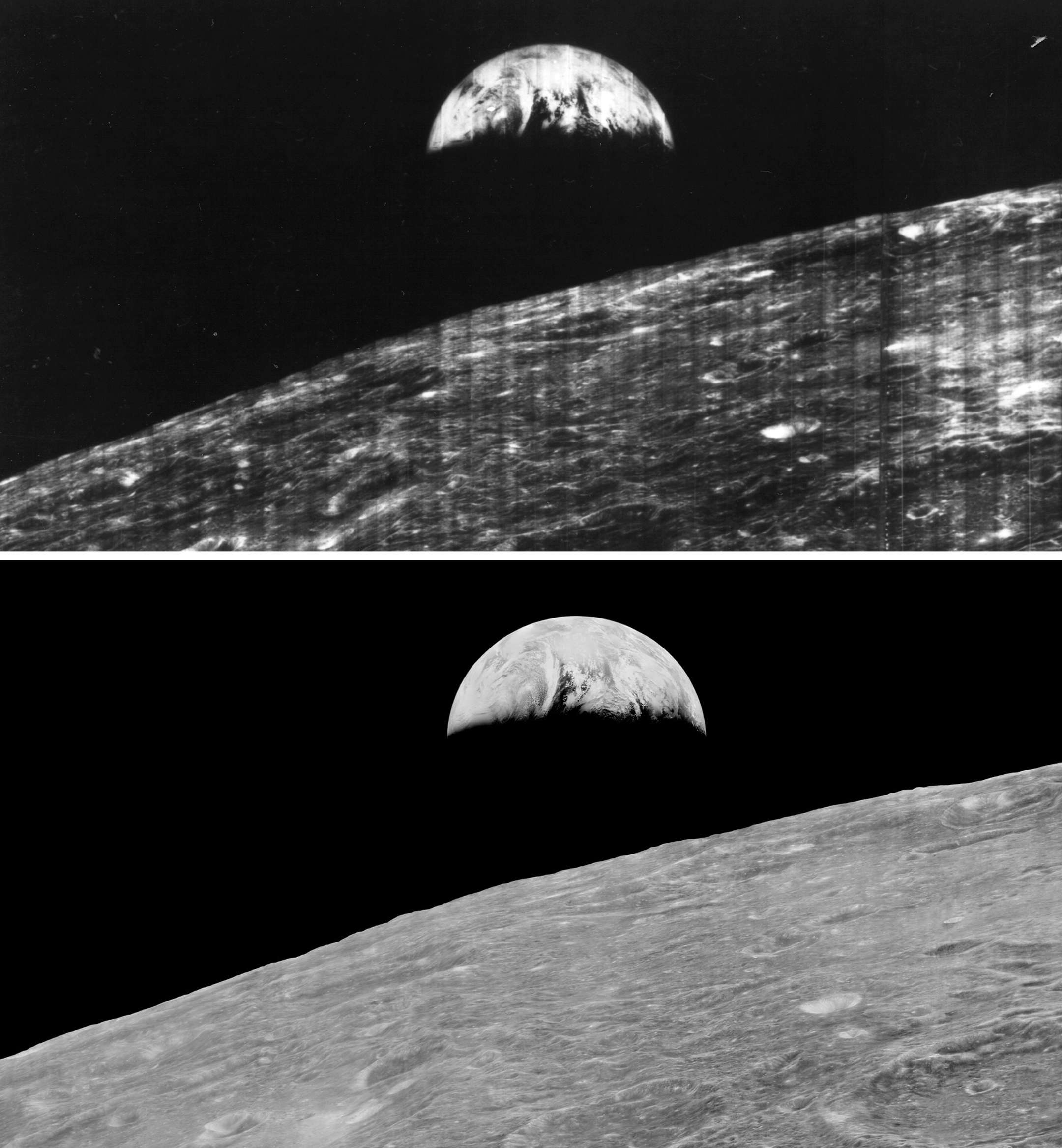
The first earthrise image, Frame 1102 (top) and the second earthrise Frame 1117 (bottom) show similar composition and viewing angles. larger image Image credit: LOIRP/NASA


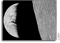
As was the case with Frame 1102, comparing the detail of Earth in the newly reprocessed LOIRP Frame 1117 on the left with that of the original image on the right shows a dramatic increase in dynamic range and resolution. Larger image.


This image shows the orientation of Earth as seen from the Moon at the time that Frame 1117 was taken on 25 August 1966 at 13:02:05 GMT.
NASA flew five Lunar Orbiter missions between 1966 and 1967 to do photo reconnaissance of possible landing sites for the upcoming Apollo Moon missions as well as to conduct scientific research on the nature of the lunar surface.
The LOIRP retrieved this image from the original magnetic tape recorded in 1966 using restored 60s era FR-900 tape drives coupled with modern digital image capture and processing techniques.  This process brought out detail that would have been impossible to see in the 1960s.  
The LOIRP’s goal is to recapture the images from all five Lunar Orbiters and to provide the high resolution images for scientists and the public.  All of the imagery and accompanying data will be submitted to the NASA Planetary Data System (PDS) as is the case with all modern NASA missions. The PDS did not exist at the time that the Lunar Orbiter missions were flown.
The primary data capture of all Lunar Orbiter images has been completed. The LOIRP expects to complete these process of retrieving all images and submitting data to the NASA Planetary Data System by the end of 2014.
Support for this project has been provided by NASA, the Solar System Exploration Research Virtual Institute, SpaceRef Interactive Inc., SkyCorp Inc., and hundreds of donors via a RocketHub crowd funding campaign last year.
More information on the Lunar Orbiter Image Recovery Project can be found at https://moonviews.wpenginepowered.com
Related links
Another Lunar Orbiter Earthrise Retrieved and Enhanced
How Life Magazine Revealed “Earthrise” in 1966
Nimbus II and Lunar Orbiter 1 Imagery: A New Look at Earth in 1966
LOIRP Releases Recovered Lunar Orbiter V Image of “Full Earth”

Another Lunar Orbiter Earthrise Retrieved and Enhanced


On the left is a newly-recovered and enhanced image of the Earth and Moon taken by Lunar Orbiter IV on 19 May 1967. On the right is how the image has looked in NASA’s records – until now. (Click on image to enlarge)
The other day, as we were going through tapes from Lunar Orbiter IV we came across a picture of the Earth and the Moon – one that was not instantly familiar to us. This image is not included in the LPI Lunar Orbiter IV image gallery but is listed in this document at LPI (click on text below to enlarge),


According to this entry at NSSDC: “Lunar Orbiter 4 photograph showing a crescent Earth and partly illuminated Moon. The lunar sunset terminator is at 140 E and runs through the large dark-floored crater Tsiolkovsky, about 240 km diameter towards the bottom of the Moon. The part of the Moon visible in this image is the western far side. North is at 1:00. The frame has been turned upside down to give the correct orientation. (Lunar Orbiter 4, frame M-123)”
Location & Time Information
Date/Time (UT): 1967-05-19 T 23:27:54
Distance/Range (km): 6151
Central Latitude/Longitude (deg): +1.13/168.38
Orbit(s): N/A

This is what the public and researchers have seen for the past 47 years (click on image to enlarge). Note that the Earth is over exposed and there is the pronounced characteristic stripping (showing individual framelets) on the lunar surface.


So we downloaded the image and set our imagery genius Austin Epps to work on the image.


The image on the left is output of our usual assembly program (click on image to enlarge). The image on the right is the result after some additional filtering to suppress the overexposure issues that Lunar Orbiter IV was having (click on image to enlarge). There is still some striping as you can see – and addressing that in very high contrast images like this one takes some additional work.

In this image Earth’s limb and terminator have been sharpened and Rousseau markers (as well as other film/readout noise) have been removed from black areas of the image.  Some additinal filtering was applied to the Moon for additional destriping. Click on the image for a larger view.
High resolution image (700 mb TIFF) at NASA SSERVI

Two Historic Earthrise Images In The News

NASA Releases New Apollo 8 Earthrise Simulation Video
“NASA has issued a new visualization of the events leading to one of the iconic photographs of the 20th Century – Earth rising over the moon captured by the crew of the Apollo 8 mission. The photo known as Earthrise is the first color photograph of Earth taken by a person in lunar orbit. Earthrise is the cover photo of TIME’s Great Images of the 20th Century, and is the central photo on the cover of LIFE’s 100 Photographs That Changed the World.”
NASA Google+ Hangout: New Visualization 45th Anniversary of Apollo 8 Viewing Earth from Space
“NASA will host a Google+ hangout at 2 p.m. EST Friday, Dec. 20, to unveil a new simulation of the events leading to the creation of “Earthrise,” one of the most iconic photographs of the 20th century. It was 45 years ago on Dec. 24, 1968, when Apollo 8 astronauts captured the photograph called “Earthrise,” the first color photograph of Earth taken by a person orbiting the moon.”


The First Earthrise Image Makes a Trip Back To The Moon
“On 19 November 2013, the first image ever taken of the Earth rising over the Moon’s surface in 1966 was sent back to the Moon. This historic image, known as “Earthrise”, was taken on 23 August 1966 by NASA’s Lunar Orbiter 1. A full resolution electronic data file over 700 Mb in size containing this image was sent to the LADEE spacecraft currently in lunar orbit and then received back on Earth. The Earthrise image that was sent to LADEE was a restored and enhanced version created by the Lunar Orbiter Image Recovery Project (LOIRP) located at the Ames Research Park at Moffett Field, California. “
How Life Magazine Revealed “Earthrise” in 1966
Lunar Echoes on STS-130


Nimbus II and Lunar Orbiter 1 Imagery: A New Look at Earth in 1966
“… the National Snow and Ice Data Center, after seeing the work that the LOIRP team had done in potentially identifying the Antarctic sea ice in the Lunar Orbiter 1 Earthrise image, and recognizing the similarity between the raw data of the Nimbus and Lunar Orbiter data, provided a grant to the LOIRP team to process the Nimbus data into a modern format and to correct image artifacts that are common to both types of images. … On this day, in New York City, just over the Earth’s limb as seen from lunar orbit, the Beatles were preparing to play at Shea Stadium …”
Beatles Legend Among Those Honored with Mercury Craters, NASA

The First Earthrise Image Makes a Trip Back To The Moon

On 19 November 2013, the first image ever taken of the Earth rising over the Moon’s surface in 1966 was sent back to the Moon.
This historic image, known as “Earthrise”, was taken on 23 August 1966 by NASA’s Lunar Orbiter 1.  A full resolution electronic data file over 700 Mb in size containing this image was sent to the LADEE spacecraft currently in lunar orbit and then received back on Earth. 
The NASA Lunar Laser Communication Demonstration (LLCD) system being tested during the LADEE mission allowed the image to be sent to and from the Moon in a fraction of the time required to originally send it back to Earth in 1966.
The Earthrise image that was sent to LADEE was a restored and enhanced version created by the Lunar Orbiter Image Recovery Project (LOIRP) located at the Ames Research Park at Moffett Field, California.  This enhanced image was originally re-released to the public in November 2008.

Continue reading “The First Earthrise Image Makes a Trip Back To The Moon”

First Earthrise Photo Taken 47 Years Ago Today

Keith’s note: 47 Years ago today, on 23 August 1966, Lunar Orbiter 1 snapped the first photo of Earth as seen from lunar orbit (Larger view). While a remarkable image at the time, the full resolution of the image was never retrieved from the data stored from the mission. In 2008, this earthrise image was restored by the Lunar Orbiter Image Recovery Project at NASA Ames Research Center. We obtained the original data tapes from the mission (the last surviving set) and restored original FR-900 tape drives to operational condition using both 60s era parts and modern electronics. The following links provide background on the image, its restoration, and reactions to its release.
Here is a comparison of the full image in its original, familiar context (higher res)(print quality). You can download a 1.2 GB version from NASA here. Note: this is a very large file.


Newly Restored Lunar Orbiter Image of Earth and Moon (Detail)
How the Photo Was Taken
House of Representatives Honors Lunar Orbiter Image Recovery Project
Nimbus II and Lunar Orbiter 1 Imagery: A New Look at Earth in 1966
Dumpster Diving for Science, Science Magazine
What Lunar Orbiter 1 Was Seeing on 23 August 1966

How Life Magazine Revealed “Earthrise” in 1966

The following two pages from the 9 September 1966 issue of Life magazine are how many people first saw the famous “earthrise” photo taken by Lunar Orbiter 1 less than two weeks earlier. The editors of Life sought to place the image in a context such that people could see what was actually in the picture. LOIRP has done similar analyses here and here. Due to the enhanced resolution of our images we were able to pin down the exact time and orientation of Earth a bit more accurately than was possible in 1966.
Click on images to enlarge.


LOIRP analysis in 2008

Lunar Orbiter Earthrise Sighting

“I saw that you had posted some Lunar Orbiter I presentation pieces. I own one of them, but until recently didn’t know much about it. In researching the picture, I learned about the story of the tapes. Here is the one that I received in 1984-85 from a nice lady I worked with at the time. It doesn’t have a plaque, or dedication, but seems framed for an executives office. Her husband worked on the project, and this was in his office. He had passed away, and she brought it to work and gave it to me as a gift. She knew I was a big space flight fan and had just got back from a shuttle launch a couple of months back, and figured I would give it a good home. I wished I would have asked more questions at the time, but I was just so surprised by it. This was in Denver, and we were both working at an Ampex sub-contractor at the time.
The picture currently resides in my editing room in my studio/office. Since it is the anniversary of the photo, I snapped a quick pic of it for my facebook page, and thought I’d drop you a note while I was at it. BTW, I love the story of the LOIRP, since I have a fondness for old gear, and technology. I also like the Colorado connection with the video magnetics guys, we were regular customers back in the day. Keep up the good work. I know everyone is all hyped up on Mars, but as a child of the 60’s, I’m all about the moon.”

Scott Sheriff, Director, SST Digital Media
www.sstdigitalmedia.com