
 “Until more formal U.S. Government guidance is developed and perhaps a multilateral approach is developed to reflect various nations’ views on lunar hardware of scientific and historic value, NASA has assembled this document that contains the collected technical knowledge of its personnel – with advice from external experts and potential space-faring entities – and provides interim recommendations for lunar vehicle design and mission planning teams. As such, this document does not represent mandatory USG or international requirements; rather, it is offered to inform lunar spacecraft mission planners interested in helping preserve and protect lunar historic artifacts and potential science opportunities for future missions.”
Full report: NASA’s Recommendations to Space-Faring Entities: How to Protect and Preserve the Historic and Scientific Value of U.S. Government Lunar Artifacts
Hacking Soviet Moon Photos
 Scooping the Soviets, Paul Spudis
“The team at Jodrell Bank assumed that the mission was over, surmising that Luna 9 probably hit the Moon too hard or was designed as a crash lander. Then to their astonishment, the probe began transmitting radio signals and the observatory recorded them, uncertain as to their meaning. Lovell thought – suppose these signals were simply an ordinary telefax communication? If these transmissions were pictures of the lunar surface, perhaps the signals the observatory recorded could be read by a commercial facsimile machine. But Jodrell Bank Observatory had no such machine; the observatory was a scientific laboratory, which in those days displayed its received radio signals in the form of line graphs made by paper strip recorders.”
Lunar Orbiter Photo Techs talk About Looking for Surveyor 1 & Luna 9 Landing Sites
This audio is from a Lunar Orbiter tape made on 24 Feb 1967. In the tape you can hear the techs talking about whether the “Surveyor” or “Luna 9” spacecraft could be seen in any images. Both spacecraft had landed on the lunar surface.
Lunakhod One Is Still In Its Parking Location
“Luna 17, carrying Lunokhod 1, landed on the flood basalt surface of Mare Imbrium on 17 November 1970, after entering orbit on 15 November. Today’s Featured Image of Luna 17 and Lunokhod 1 was obtained during a low altitude (33 km) pass providing the highest resolution view yet of the landing site.”
NASA LRO Image: Luna 24 Sitting On The Lunar Surface
 Luna 24 landed on the northwestern rim of a 64 m diameter impact crater, on the volcanic plains of Mare Crisium. Enlargement of lander at lower left, NAC M174868307L [NASA/GSFC/Arizona State University].
Three Soviet missions (Luna 16, Luna 20, and Luna 24) successfully collected and returned pieces of the lunar surface. Before the successful Luna 24 sample return mission in August 1976, Luna 23 was sent two years earlier (November 1974) to nearly the same location in Mare Crisium, but was unsuccessful.
Luna 24 landed in Mare Crisium on 18 August 1976 to complete the unfinished mission of Luna 23. The landing sites of Luna 23 and 24 are only 2.3 km apart. The region of Mare Crisium where they landed is a typical smooth mare surface with little relief in the immediate vicinity. There are numerous secondary craters scattered across the region, and Luna 24 landed on the edge of one of these. The secondary craters are the result of an impact to the northeast of the landing site, perhaps from the crater Giordano Bruno.
More information and imagery.
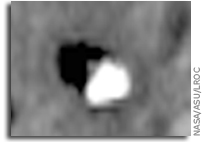
NASA LRO Image: Luna 23’s Rough Landing On The Moon
 Unfortunately, Luna 23 experienced a malfunction and hit the surface at a very high velocity. Contact was maintained between Earth and the spacecraft after landing, but a sample could not be acquired. At the time, the cause of the failure was not known, but it seemed probable that the whole spacecraft tipped over upon landing at an unexpectedly high velocity. Indeed, the high resolution LROC NAC image (below) shows the spacecraft lying on its side!
More information and imagery.
LOIRP Releases Recovered Lunar Orbiter III Image of Surveyor 1 On the Lunar Surface

This image (LO3_194_H3) was taken by Lunar Orbiter III on 22 February 1967 at 5:24:14 GMT at an altitude of 54.27 km above the lunar surface. High resolution frame 3 clearly shows the Surveyor 1 spacecraft sitting on the lunar surface complete with a long shadow.
Surveyor 1 landed on the Moon on 2 June 1966 in the Ocean of Storms (Oceanus Procellarum) at 2.45 degrees South latitude, 43.22 degrees West longitude.

Larger view
This image has been recovered in its original high resolution format by LOIRP staff from original Lunar Orbiter project data tapes using restored tape drive hardware and will eventually be submitted to the PDS (Planetary Data System).
A full resolution version of this image will be placed online at the NASA Lunar Science Institute.
The Lunar Orbiter Image Recovery Project (LOIRP) is located at the NASA Ames Research Center in Moffett Field, CA. Funding and support for this project has been provided by NASA Exploration Systems Mission Directorate, NASA Innovative Partnerships Program, NASA Lunar Science Institute, NASA Ames Research Center, Odyssey Moon LLC, SkyCorp Inc., and SpaceRef Interactive Inc.
For more information on the Lunar Orbiter Image Recovery Project (LOIRP) visit https://moonviews.wpenginepowered.com
For information on NASA’s Lunar Science Institute visit http://lunarscience.arc.nasa.gov/
For information on NASA’s Exploration Systems Mission Directorate visit http://www.nasa.gov/exploration/
Surveyor I: Location and Indentification, Science
Science 11 August 1967: Vol. 157 no. 3789 pp. 681-684
DOI: 10.1126/science.157.3789.681
L. Harold Spradley, R. Steinbacher, M. Grolier, C. Byrne
Surveyor I landed on the lunar surface on 2 June 1966 and obtained more than 11,000 pictures of the environment with its television camera. The same region was photographed by the 24-inch (61-centimeter) camera of Orbiter III on 22 February 1967. Surveyor I has been located in these Orbiter photographs; its image was found and all search and identification criteria were satisfied by the site.
Related Document
Lunar coordinates of Surveyor 1, Charles J. Byrne, 28 April 1967
Apollo Landing Site Ellipse II-P-13

Ellipse II-P-13, located in Oceanus Procellarum. The center coordinates for the ellipse are 1 degree 40 minutes north longitude and 41 degrees 40 minutes west latitude. It was the thirteenth and last primary site photographed by Lunar Orbiter II. It is the western most of the Set C Mission I sites.
Apollo Landing Site Ellipse II-P-8

Ellipse II-P-8, located in Sinus Medii near the center of the moon. The center coordinates for the ellipse are 0 degrees 25 minutes north longitude and 1 degree 20 minutes west latitude. It was the eighth primary site photographed by Lunar Orbiter II. Surveyor VI landed approximately five kilometers to the northwest from the center of the ellipse.