
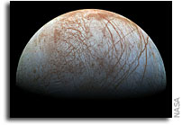
 Scientists have produced a new version of what is perhaps NASA’s best view of Jupiter’s ice-covered moon, Europa. The mosaic of color images was obtained in the late 1990s by NASA’s Galileo spacecraft. This is the first time that NASA is publishing a version of the scene produced using modern image processing techniques. An earlier, lower-resolution version of the view, published in 2001, featured colors that had been strongly enhanced. The new image more closely approximates what the human eye would see. Space imaging enthusiasts have produced their own versions of the view using the publicly available data, but NASA has not previously issued its own rendition using near-natural color.
More
Priority vs Final Readout of Lunar Orbiter Images

Dennis WIngo: This image (click on image to enlarge) shows the sequence of images that were read out during what is termed “priority” readout vs the “final readout”. The priority readout was an opportunistic scanning of processed photos on the lunar orbiter before all of the images were taken. The photo process with the 70mm film began with an image being simultaneously taken by the 610 mm high resolution camera and by the 80 mm medium resolution camera. In a process remarkably similar to the old polaroid dry process instamatic cameras, the film was dry processed by a “bimat” dry processor. The bimat would separate from the film (most of the time) but would sometimes due to the timing would leave artifacts on the image, which are readily identified on the film.
The film would then be fed into the readout looper where it could be scanned and the images sent back to the Earth. During the mission when photographs were still being taken the film would run one direction through the looper. After all of the images were taken a command would be sent to cut the bimat and then the film could be read in the opposite direction.
Thus when we start with a low numbered tape, the first images that come off are from the priority readout in ascending order. However, the ascending order is not linear, jumping because images are still being taken and the film advancing while the spacecraft cannot transmit. The image of the day today shows what images are taken in ascending sequence (orbit) format. You can see the jumps. If you are really good you can see what images we are recording and then predict what the next images will be … At least during the priority readout.
How Do We Find Lunar Orbiter Images?

Dennis Wingo: Several people were interested in our process yesterday so here is some more information on what we do to figure out the images on the tapes. [Click on image to enlarge].
We almost always start with the low numbered tapes and go up, just like in the real mission. As stated yesterday, we picked Woomera because it had the most ground station time. There is 163 tapes for the Woomera LO-V, more than 50-60 tapes than for the previous LO’s. We think that there is some duplication there but we won’t know until we get all of the Woomera tapes done, then process the raw framelets. Austin then generates a report based upon our knowledge of all of the framelets for LO-V, which then tells us what we have left to do. We then will start on the Goldstone tapes.
Video: Oscilloscope Trace of Lunar Orbiter Image Playback
Dennis Wingo: This is a two minute video that shows, about every 42 seconds, a shift in the video. This occurs when the line is scanned to the end of a framelet, over the calibration features that were pre recorded in the tape. Keith has posted images here that show the relationship between the scope trace and the dynamic range of the tapes. This gives us a qualitative measure of the performance of the tape drive. Even in its sub optimized state today, the scope trace almost exactly matches the original transfer function of the spacecraft film, thus giving us a means to evaluate the quality of the analog data derived from the tape.
Using Software to Rectify a Photo About Mechanical Photo Rectification
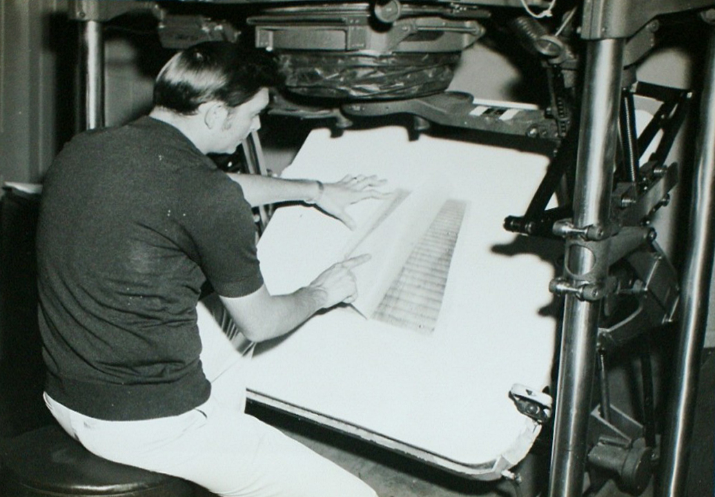
Original caption: St. Louis, Mo. — RECTIFYING A LUNAR PHOTO — Mr. Ralph Wilson of the U.S. Air Force Aeronautical Chart and Information Center uses photographic equipment to rectify a composite of Lunar Orbiter Photos. Rectification is accomplished by tilting the composite on the easel until the crater and other features can be photographed at a predetermined angle. (U.S. Air Force Photo).
 Keith Cowing: I found this photo on eBay. As you can see it was warped. So I used Photoshop to do a quick “rectification” so as to present the photo as it would have looked if it was laid flat. Back in the Lunar Orbiter days they did not have Photoshop – so they had to use this mechanical / optical process – one that had a clear military heritage.
Click on top image to enlarge.
Comparing USGS, LOIRP, and LRO Images of Copernicus
The Lunar Orbiter Image Recovery Project (LOIRP) Comparison of LO Copernicus Central Uplift with LRO LROC Mosaic. Poster presented by the LOIRP at the 2012 Lunar Science Forum

LRO Imagery Helps Locate Titanium on the Moon
 Subtly Shaded Map of the Moon Reveals Titanium Treasure Troves
“A map of the Moon combining observations in visible and ultraviolet wavelengths shows a treasure trove of areas rich in titanium ores. Not only is titanium a valuable element, it is key to helping scientists unravel the mysteries of the Moon’s interior. Mark Robinson and Brett Denevi will be presenting the results from the Lunar Reconnaissance Orbiter mission today at the joint meeting of the European Planetary Science Congress and the American Astronomical Society’s Division for Planetary Sciences.”
First TV Image of Mars From Mariner IV in 1964 – Hand Colored
 A ‘real-time data translator’ machine converted a Mariner 4 digital image data into numbers printed on strips of paper. Too anxious to wait for the official processed image, employees from the Voyager Telecommunications Section at NASA’s Jet Propulsion Laboratory, attached these strips side by side to a display panel and hand colored the numbers like a paint-by-numbers picture. More.
LOIRP LPSC Student Poster: New Lunar Crater Search Using LROC-NAC vs LOIRP Lunar Orbiter Images

Click on image for PDF version of poster
Poster presented at the 42nd Lunar and Planetary Science Conference by N. G. Moss, T. M. Harper, M. B. Motta, A. D. Epps
“While some candidate craters were observed that appeared in LROC data but not in Lunar Orbiter data, these were all very near the edge of discernable feature size and are almost certainly explained by various differences between the images (e.g. sun angle or viewing geometry). While our initial search did not find any discernable new cratering, we have shown that data from the original analog Lunar Orbiter tapes, as recovered by the Lunar Orbiter Image Recovery project, possesses the characteristics necessary to discern new craters at reasonably small sizes. If the entire Lunar Orbiter data set was recovered in this manner it may be possible for future researchers to apply automated methods to detect changes with much better chances of success.”
Technoarchaeology: Where is the True “First” Picture taken by Tiros 1?

The NASA Goddard Library TIROS-1 Photographic Atlas Collection of Weather Photos from Space and the “First” Weather Image
91st American Meteorological Society Annual Meeting
Wednesday, 26 January 2011: 4:15 PM
304 (Washington State Convention Center)
Gene Major, Library Associates, NASA/GSFC Library, Lanham, MD
TIROS 1, the Television Infra-Red Observation Satellite, was launched 50 years ago on April 1, 1960 from Cape Canaveral, Florida. It was the first satellite designed to observe clouds from space and is the precursor to dozens of meteorological operational and research satellites. TIROS only lasted 3 months, but it made 1,392 orbits and took nearly 23,000 pictures. The NASA Goddard Library has a rare and unique collection of 26 bound volumes of TIROS 1 photography prepared by the Navy in 1961 specifically for NASA Goddard Space Flight Center. This talk will highlight the collection, attempts contemplated to preserve it, and revelations that the “first” image from TIROS, widely distributed around the internet (and even by NOAA and NASA), was not the first photo, nor even taken on the first day of operations!
Keith Cowing at Maker Faire: Hacking NASA
“Keith Cowing talks about the kind of hacks made famous by the Apollo 13 mission, instances where the crew had to improvise using materials at hand. He discusses the following: Skylab Rescue – the umbrella used to replace solar insulation and boating tools bought at a local marina; Syncom Rescue – tools made out of plastic and duct tape; Apollo 13 CO2 removal, use of LEM engine, etc.; Apollo lunar rover fender repair; STS-120 EVA solar panel repair, and ISS camera tracker made from a power tool. Cowing also talks about some of his own projects including the greenhouse he designed and built on Devon Island (and some serious hacks) near the North Pole. Currently, he’s working in partnership with NASA Ames to restore a 1960’s era Titan I ICBM & convert it for educational use.”
More information: moonviews.com, nasahackerspace.org
National Snow and Ice Data Center on LOIRP
 Techno-Archaeology Rescues Climate Data from Early Satellites, National Snow and Ice Data Center
Image: Forty-three years after the Nimbus II satellite collected these data, a team from NSIDC and NASA recovered a global image from September 23, 1966. In this view over Antarctica, overlaid on Google Earth, the Ross Ice Shelf appears clearly at left.
“Starting with the methods developed for the Lunar Orbiter Image Recovery Project (LOIRP) at NASA Ames Research Park, a team at NSIDC worked with Dennis Wingo at LOIRP to search NASA archives for the original Nimbus tapes containing raw images and calibrations. Their first goal was to read and reprocess the data at a higher resolution, removing errors resulting from the limits of the original processing.”