
 Kodak has played big role in space program, Democrat and Chronicle
“Kodak designed and built the cameras and film processing used in the five lunar orbiters sent to photograph the moon’s surface in 1966 and 1967 in preparation for the manned landing. Those orbiters shot panoramic strips of the lunar surface and transmitted them back to Earth before the orbiters crashed into the moon, said Todd Gustavson, curator of technology at the George Eastman House.”
To the Moon – with extreme engineering – Spontaneous, improvised – would it be allowed to happen now?, The Register
“It’s a temptation, watching many of the 40th Anniversary retrospectives, to think of the Apollo space program as a triumph of power and industrial might. The superpowers’ space programs were, of course, political and chauvinistic, designed to showcase national wealth. But there’s a better way of looking at the program, Dennis Wingo reminded me recently. Masses of money helped put man on the Moon of course, but the Moon program is really a tale of engineering improvisation and human organisation. … The Lunar Orbiter astonishes even today. It had to take pictures, scan and develop the film on board, and broadcast it successfully back to earth. Naturally, the orbiter had to provide its own power, orient itself without intervention from ground control, and maintain precise temperature conditions and air pressure for the film processing, and protect itself from solar radiation and cosmic rays – all within severe size and weight constraints. This was far beyond the capabilities of the newest spy satellites, which back then returned the film to earth in a canister, retrieved by a specially kitted-out plane. The Orbiter challenge was the Apollo challenge in miniature.”
Let’s Name the LCROSS Impact Crater After Walter Cronkite

Editor’s note: The other night I started to Twitter that I thought it would be a good idea that the crater LCROSS will form should be named in honor of veteran space journalist Walter Cronkite who died the other day. Others joined in and repeated that idea.
So what is the LCROSS_NASA team’s response? They dodge the issue: “Our team heard your requests. When it comes to naming craters, it is up to the IAU. NASA can explore possibility of petition to IAU to name.”
As you will recall during Apollo missions, crew members named craters and other features. And the Mars rover people name craters, rocks, pebbles, and all manner of things all the time. Do they ask the IAU for permission to do that? NO. Indeed, the names given to rocks at the Viking lander sites in 1976 by mission personel are still in use.
So c’mon guys. Use a little imagination – use crowd sourcing and involve the public – the same public who paid for your mission and who were well served by Mr. Cronkite for decades. LCROSS can certainly recommend a name and use their own name in the mean time. There is no legally binding reason to prohibit NASA from doing this – nothing IAU does has the force of law. Indeed, the IAU does not have any interest whatsoever in the view of the public anyway.
To virtually all who watched him, Walter Cronkite was always a face on a screen – one painted upon our eyes by photons. Imagine how many thousands – maybe millions – would now stop for a moment to watch as this crater was created in his name? How often can you stand in your backyard and see that? In so doing, Walter Cronkite can have one last stupendous effect on the world – from the Moon – through a blast of photons travelling one last time to our eyes.
Continue reading “Let’s Name the LCROSS Impact Crater After Walter Cronkite”
Damaged Tape and Murky Moon Views

Image: Our retrieved image with the location of Apollo 11’s Eagle Descent Stage.
With the 40th anniversary of Apollo 11’s landing on the Moon upon us, everything old is new – or so it would seem. Yesterday we saw digitally re-mastered footage released showing the first steps on the Moon in unprecedented clarity. Also this was made from a copy that itself was a copy. The original video, recorded live as the Moon walks were underway has slipped into history – either misfiled or, more likely, erased and reused years later – much like a floppy disk. That said, the new footage does provide a window into the past with detail heretofore unseen.
Another place where windows are being opened into the past is the Lunar Orbiter Image Recovery Project (LOIRP) housed at NASA Ames Research Center. Utilizing ancient FR-900 tape drives, thousands of pounds of long forgotten image tapes, lots of loaned help including retired engineers and scientists, some money (from NASA ESMD, ARC, IPP, and NLSI, SkyCorp, and SpaceRef Interactive, and Odyssey Moon) and an old abandoned McDonalds restaurant (it was available – we call it “McMoons”), we’ve been able to bring these images back to life at resolutions greater than ever seen before. In many cases, until Lunar Reconnaissance Orbiter (LRO) takes new images, thee tapes represent the highest resolution images of the Moon ever taken from orbit.
As we ponder the sad news that the original Apollo 11 video has been lost, it is important to note that our Lunar Orbiter tapes might otherwise have been destroyed several years ago had not a stop order been placed on their destruction due to NASA’s search for Apollo 11 tapes and data. One project’s sad news is another’s execution reprieve.
Among our successes has been bringing the iconic Earthrise and Copernicus back to life in unprecedented detail. This time we need to report a major disappointment.
We recently released two Apollo landing site images – Apollo 12 and Apollo 14 and had embarked upon getting an nice crisp image of the Apollo 11 landing site in time for the anniversary.
Alas, unlike the unprecedented resolution we obtained for these two sites, Apollo 11 was a let down. The image is murky and far less clear than previous images. This is not due to the Lunar Orbiter spacecraft or our restored hardware. Rather, we expect, it had to do with someone playing this tape years ago and getting it jammed for an instant. Alas, the interesting part of this tape is framelet 411 which shows the Apollo 11 landing site. So, if there was a natural place on this tape to be paused, rewound, and played again and again and again, it is this location. Little surprise that the chance for damage to this portion of the tape occurred.
Our collection of tapes covers the entire five mission Lunar Orbiter project. While we are getting better at deciphering the nomenclature and labeling on the tapes, we still have much to learn. We can now find a specific tape and image in a straight forward process but have still only scratched the surface. And, paradoxically, we seem to have more tapes marked “Lunar Orbiter V” than we need to contain all of the images from that mission. We suspect that we have two (or more) archival collections mixed in or (for some reason) multiple copies of the same images. The only way to know for sure is to look at every tape – one by one.
The path to getting this Apollo 11 landing site image was complicated. The image was taken by Lunar Orbiter V on 12 August 1967 at 22:21:13.809 GMT at an altitude of 98. km. Properly retrieved, the resolution of our image should be 2.387 meters per pixel.
After our first round of image retrievals, the heads for our FR-900 tape drive needed to be refurbished. This is an expensive and time consuming process with only one or two places in the world capable of doing it. With the heads refurbished we were prepared to run the tape. As we did we found out that our custom made frame grabber had a bad chip which needed to be replaced.
Once the gear was good to go, the process of running the tape began. There was an ominous note on the tape can that a section of the tape might be damaged. We soon discovered that indeed there was some damage to a 4 minute segment and it was the portion we were most interested in.
Undaunted, Ken Zin, our experienced video tape drive engineer, Al Sturm our electronics guru, and Austin Epps, our vigilant student intern worked long hours to get everything working to see what sort of image we could get. Austin ran the tape multiple times os as to get multiple images we could use to produce a super resolution image of the landing site.
Despite this attempt to coax a little clarity out of the noise, the damage to the tape precluded an image of the quality we had hope for – and had achieved for other images. That disappointment aside, we feel that it is important to show our failures and disappointments as well as our crowning achievements. As you will see when you compare it to the best Lunar Orbiter images, the resolution is low. Yet if you compare it with the new LRO images you can clearly see that something appeared in the image and that the regolith was disturbed around that object (humans).
We will be combing through the Lunar Orbiter tapes this weekend with the hope that there is another (hopefully undamaged) version of this image.
We feel that it is equally important to reveal our failures and disappointments as it is to crow about our successes. We expect to have many of both.
Such is the curse of Apollo 11 – for an event so epic in its nature, the frail means where by we captured it and the planning that led up to it – are fleeting. One more reason why all of this fragile history needs to be maintained with constant vigilance – else we lose all of this to the dust of time.
For more information on the Lunar Orbiter Image Recovery Project (LOIRP) visit https://moonviews.wpenginepowered.com
For information on NASA’s Lunar Science Institute visit http://lunarscience.arc.nasa.gov/

Figure 1 Our retrieved image with the location of Apollo 11’s Eagle Descent Stage.

Figure 2 Comparing our retrieved image and that scanned by the USGS

Figure 3 Comparing our retrieved image, one scanned by the USGS, and LRO’s recent image.
Apollo 11: Before and After
 Moon Orbiter to Photograph Apollo 11 Landing Site, Space.com
“Taking the something old, something new approach is the Lunar Orbiter Image Recovery Project, located at the Ames Research Center in the heart of California’s Silicon Valley. This team effort is led by Dennis Wingo of SkyCorp, Inc. in Huntsville, Alabama and Keith Cowing of SpaceRef Interactive, Inc. of Reston, Virginia.
The recovery project involves culling through some 1,700 images taken by NASA Lunar Orbiter missions from the 1960’s, convert that data into digital form and then reconstruct the images to yield 21st century pictures far superior than the originals.
Ideally, upgrading an old Lunar Orbiter image taken of the Apollo 11 landing zone before Armstrong and Aldrin set foot there, contrasted to a new LRO overhead shot, would present a unique before/after look-see of the historic Tranquility Base site, said Greg Schmidt, deputy director of the NASA Ames-based Lunar Science Institute.
The Apollo sites themselves are extremely well characterized thanks to human explorers dispatched to those individual locales, Schmidt noted. LRO images of these areas will let us see the landers — and likely other artifacts such as the lunar buggies used in the Apollo 15, 16, and 17 missions – all of which will no doubt be very powerful in ways beyond mere science, he said.”
Remastered Apollo 11 Tapes
 NASA Holds Briefing to Release Restored Apollo 11 Moonwalk Video
“NASA will hold a media briefing at 11 a.m. EDT on Thursday, July 16, at the Newseum in Washington to release greatly improved video imagery from the July 1969 live broadcast of the Apollo 11 moonwalk. The release will feature 15 key moments from Neil Armstrong’s and Buzz Aldrin’s historic moonwalk using what is believed to be the best available broadcast-format copies of the lunar excursion, some of which had been locked away for nearly 40 years. The initial video released Thursday is part of a comprehensive Apollo 11 moonwalk restoration project expected to be completed by the fall. The Newseum is located at 555 Pennsylvania Ave. N.W. The news conference will be broadcast live on NASA Television and streamed on the agency’s Internet homepage.”
LRO’s First Images Of The Moon
 First Moon Images From NASA’s Lunar Reconnaissance Orbiter
“NASA’s Lunar Reconnaissance Orbiter has transmitted its first images since reaching the moon on June 23. The spacecraft’s two cameras, collectively known as the Lunar Reconnaissance Orbiter Camera, or LROC, were activated June 30. The cameras are working well and have returned images of a region in the lunar highlands south of Mare Nubium (Sea of Clouds). As the moon rotates beneath LRO, LROC gradually will build up photographic maps of the lunar surface.
“Our first images were taken along the moon’s terminator — the dividing line between day and night — making us initially unsure of how they would turn out,” said LROC Principal Investigator Mark Robinson of Arizona State University in Tempe. “Because of the deep shadowing, subtle topography is exaggerated, suggesting a craggy and inhospitable surface. In reality, the area is similar to the region where the Apollo 16 astronauts safely explored in 1972. While these are magnificent in their own right, the main message is that LROC is nearly ready to begin its mission.”
LOIRP Article in Computer World: How We Got The Images
The lost NASA tapes: Restoring lunar images after 40 years in the vault, Computerworld
“Liquid nitrogen, vegetable steamers, Macintosh workstations and old, refrigerator-size tape drives. These are just some of the tools a new breed of Space Age archeologists is using to sift through the digital debris from the early days of NASA, mining the information in ways unimaginable when it was first gathered four decades ago. At stake is data that could show Earth’s risk of an asteroid strike, shed light on global warming and — perhaps — even satisfy those who think the moon landings were a hoax. The most visible of the archeologists is arguably Dennis Wingo, head of Skycorp Inc., a small aerospace engineering firm in Huntsville, Ala. He’s the driving force behind the Lunar Orbiter Image Recovery Project, operating out of a decommissioned McDonald’s (since dubbed McMoon’s) at NASA’s Ames Research Center in Mountain View, Calif. The project’s goal is to recover and enhance as many of the original lunar landing images as possible.”
The Story of Project McMoon’s – As Reported in Italy
La luna nel forno – La storia del progetto McMoon, Wittgenstein
“Nello spazio nessuno puo sentirti urlare”. Non c’e atmosfera, e il suono non si propaga. Nemmeno sulla luna. Lo schianto contro la superficie lunare di quei cinque accrocchi grandi come un chiosco dei gelati avvenne nel silenzio. Di loro non restarono che i racconti. Questa storia era cominciata prima. Il primo Lunar Orbiter fu lanciato nello spazio il 10 agosto 1966. A bordo non c’era nessuno. La sua missione era di fotografare la superficie lunare in preparazione dello sbarco dell’Apollo 11, che sarebbe avvenuto tre anni dopo. Allo stesso scopo, altri quattro apparecchi simili furono inviati intorno alla luna nei mesi successivi.”
Moon Missions – 40 Years Apart – But Still Like Minded
This pirate flag image sits at the bottom of the LRO Mission Team’s Blog. At the Lunar Orbiter Image Recovery Project (LOIRP) located in an abandoned McDonalds outside the gate at ARC, we adopted a similar motif … we fly a similar flag in our front window and opened our recent presentation at the Apple World Wide Developers Conference with one as well. We even have t-shirts for sale!

LOIRP In The News
Moon’s South Pole Gets Close-Up in Restored Photos, space.com
“Newly restored photographs of the moon’s dark south pole, taken by lunar orbiters in 1967, were released this week in anticipation of NASA’s planned Thursday launch of two new probes that will investigate the region in search of underground ice.”
More Photos From the Lunar Time Machine, Universe Today
“The LOIRP team is working on digitizing the data, and restoring the images to their full resolution. These images are especially timely, given the upcoming launch of the Lunar Reconnaissance Orbiter, hopefully this week. NASA can compare detailed high-resolution images from 1966 to the present and see what changes occurred in 40-plus years. “What this gives you is literally before and after photos,” Cowing said.”
Lunar Orbiter III-154-H2, Lunar Networks
“In fact, there is a lot of Cold War, personal and science history in this otherwise ordinary-looking shot of apparently unremarkable lunar landscape. The folks at Moonviews have now added their own and very welcome contribution.”
LOIRP recovers Lunar Orbiter IV lunar south pole image from 1967, Lunar Networks
“For the third time in one week Moonviews, the Lunar Orbiter Image Restoration Project (LOIRP) has released another spectacular total restoration taken from multiple passes over magnetic tape retaining data downloaded directly during the U.S. Lunar Orbiter series (1966-1968).”
Lunar Orbiter Image Recovery Project (LOIRP) Releases New Image of Apollo 12/Surveyor III Landing Site
This image LO3-154-H was taken by Lunar Orbiter III on 20 February 1967 and shows the landing site for both Surveyor III (landed 20 April 1967) and Apollo 12 (landed 19 November 1969).
Figure 1 shows the region without labels. Figure 2 shows major features plus EVA routes.

Figure 1: Apollo 12/Surveyor III landing site as seen by Lunar Orbiter III (larger image)

Figure: 2 Apollo 12/Surveyor III landing site as seen by Lunar Orbiter III with prominent features and EVA routes (larger image)
This image has been recovered in its original high resolution format from original Lunar Orbiter project data tapes using restored tape drive hardware and will eventually be submitted to the PDS (Planetary Data System).
LOIRP Note: We will be putting the full resolution version of this image on the NASA Lunar Science Institute website with the layers preserved for Photoshop for all you folks to have fun with! We only ask that you send us copies of what you do and credit us if you publish it anywhere.
For more information on the Lunar Orbiter Image Recovery Project (LOIRP) visit https://moonviews.wpenginepowered.com
For information on NASA’s Lunar Science Institute visit http://lunarscience.arc.nasa.gov/
Lunar Orbiter Image Recovery Project (LOIRP) Releases New Image of the Moon’s South Pole
This image was taken by Lunar Orbiter IV in May 1967 and shows the south pole of the Moon. Figure 1 shows the region without labels. Figure 2 shows major features plus notation regarding processing artifacts from the spacecraft’s film processing system. The moon’s south pole is located near the rim of Shackleton Crater.
Adjacent to the south pole is Shoemaker crater named in honor of famed planetary geologist Eugene Shoemaker. The Lunar Prospector spacecraft, carrying some of Shoemaker’s ashes, was deliberately crashed in this crater in an attempt to see if any water ice would be thrown up by the impact.
The Lunar CRater Observation and Sensing Satellite (LCROSS) will be targeted to impact at the south pole of the moon. As such, the moon’s polar regions are of great interest right now.

Figure 1 South Pole of the moon as seen by Lunar Orbiter IV (larger image)
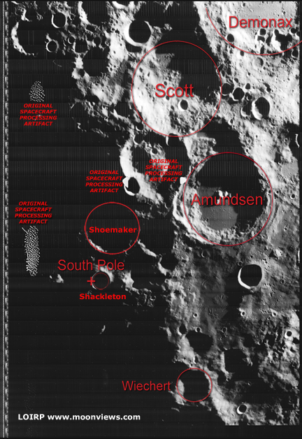
Figure 2 South Pole of the moon as seen by Lunar Orbiter IV with prominent features and processing artifacts identified (larger image)
This image has been recovered in its original high resolution format from original Lunar Orbiter project data tapes using restored tape drive hardware and will eventually be submitted to the PDS (Planetary Data System).
LOIRP Note: We will be putting the full resolution version of this image on the NASA Lunar Science Institute website with the layers preserved for Photoshop for all you folks to have fun with! We only ask that you send us copies of what you do and credit us if you publish it anywhere.
For more information on the Lunar Orbiter Image Recovery Project (LOIRP) visit https://moonviews.wpenginepowered.com
For information on NASA’s Lunar Science Institute visit http://lunarscience.arc.nasa.gov/