Lunar Craters Provisionally Named for Columbia Astronauts


Names for seven craters in the Apollo basin on the Moon have been provisionally approved by the International Astronomical Union to honor the seven Space Shuttle Columbia astronauts. The names can be seen in the list of lunar crater names in the Gazetteer of Planetary Nomenclature.
The names are: Husband, McCool, Chawla, L. Clark, M. Anderson, D. Brown, Ramon.
Note that first initials have been used for Anderson, Brown, and Clark to distingiush them from other crater names on the Moon which honor persons with the same surnames. [Larger image] (source: USGS Astrogeology Center)

Challenger Astronauts Memorialized on the Moon


Image: Craters in the center of Apollo basin (36°S, 209°E) named after Space Shuttle Challenger astronauts, LROC WAC mosaic, ~190 km wide [NASA/GSFC/Arizona State University].
Apollo is a 524 km-diameter impact basin located within the center of the the giant South Pole-Aitken basin. Apollo is also a Constellation Project Region of Interest, identified by NASA as a notional area for future human lunar exploration. The Constellation Region of Interest is located in the southwest corner of the mare deposit that fills this basin-within-a-basin.
After the loss of the Space Shuttle Challenger, seven craters on the eastern rim of this basin were named after the crew: Gregory Jarvis, Christa McAuliffe, Ronald McNair, Ellison Onizuka, Judith Resnik, Dick Scobee, Michael Smith.
Go to the WAC mosaic of the entire Apollo basin and surroundings.
More information and images at LROC

Technoarchaeology: Where is the True “First” Picture taken by Tiros 1?


The NASA Goddard Library TIROS-1 Photographic Atlas Collection of Weather Photos from Space and the “First” Weather Image
91st American Meteorological Society Annual Meeting
Wednesday, 26 January 2011: 4:15 PM
304 (Washington State Convention Center)
Gene Major, Library Associates, NASA/GSFC Library, Lanham, MD
TIROS 1, the Television Infra-Red Observation Satellite, was launched 50 years ago on April 1, 1960 from Cape Canaveral, Florida. It was the first satellite designed to observe clouds from space and is the precursor to dozens of meteorological operational and research satellites. TIROS only lasted 3 months, but it made 1,392 orbits and took nearly 23,000 pictures. The NASA Goddard Library has a rare and unique collection of 26 bound volumes of TIROS 1 photography prepared by the Navy in 1961 specifically for NASA Goddard Space Flight Center. This talk will highlight the collection, attempts contemplated to preserve it, and revelations that the “first” image from TIROS, widely distributed around the internet (and even by NOAA and NASA), was not the first photo, nor even taken on the first day of operations!

Lunar Coordinates Now Available in ULCN 2005

In 2010, the coordinates of the named features in the lunar portion of the nomenclature database were updated from values from historical sources to values in the coordinate frame of the Unified Lunar Control Network 2005 (ULCN 2005, see http://pubs.usgs.gov/of/2006/1367/). The purpose of this work was to facilitate the identification of named lunar features. Dots representing the coordinates of the centers of named features will fall in the centers of the features when displayed on any map product that was created using the same ULCN 2005 control network.

Continue reading “Lunar Coordinates Now Available in ULCN 2005”

1:1 Million-Scale USGS Maps of the Moon


There are many excellent maps and atlases of the Moon in print and online, with each addressing a particular objective or community. Some maps were created for lunar astronomical observers, some feature a specific type of image, and others concentrate on global coverage or a particular region of the Moon. However, none of these sources provides an up-to-date and comprehensive picture of lunar nomenclature. The lunar maps presented here have two purposes: (1) to bring together the wealth of information on the locations of named features on the Moon into a single source and (2) to keep this source current so users have access to the most recent changes in lunar nomenclature.
The International Astronomical Union (IAU) is the internationally recognized authority for assigning nomenclature to planetary surface features. The lunar maps on this web site are based on the information contained in the Gazetteer of Planetary Nomenclature, which is a dynamic listing of IAU-approved planetary surface feature names. The Astrogeology Team of the U.S. Geological Survey maintains the Gazetteer of Planetary Nomenclature on behalf of the IAU with funding from the National Aeronautics and Space Administration (NASA). More at USGS

NASA Lunar Orbiter Video: Assignment, Shoot the Moon (1967)

National Archives: “This film summarizes the exploration of the Moon conducted through unmanned Ranger, Surveyor and Lunar Orbiter spacecraft, and shows how such detailed data and photography contributed to the first manned flights to the Moon. The film describes the complexities of closeup photography of the Moon, and includes good views of craters, mountain ranges and other lunar terrain. This film received the following awards: Golden Eagle Certificate, Council on International Nontheatrical Events (CINE), 1968; and the Award of Merit, American Film Festival, 1968.”
Transcript below

Continue reading “NASA Lunar Orbiter Video: Assignment, Shoot the Moon (1967)”

Have You Seen This Large Lunar Orbiter “Earthrise” Presentation from 1966?


[Click on image to enlarge] Does any one at NASA Langley Research Center (or elsewhere in/around NASA) know where this large reproduction of the Lunar Orbiter 1 “Earthrise” image (or others like it) are currently located? Please drop an email to lunarorbiter-at-spaceref.com – thanks!
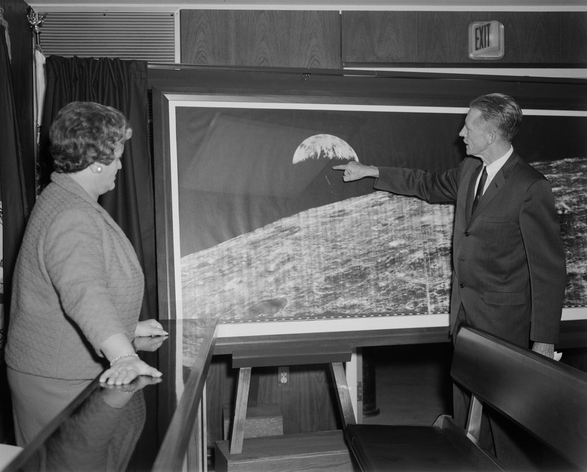
Image date: 12.14.1966 Caption: “Langley Center Director Floyd Thompson shows Ann Kilgore the “picture of the century.” This was the first picture of the earth taken from space. From Spaceflight Revolution: “On 23 August 1966 just as Lunar Orbiter I was about to pass behind the moon, mission controllers executed the necessary maneuvers to point the camera away from the lunar surface and toward the earth. The result was the world’s first view of the earth from space. It was called “the picture of the century’ and “the greatest shot taken since the invention of photography.” Not even the color photos of the earth taken during the Apollo missions superseded the impact of this first image of our planet as a little island of life floating in the black and infinite sea of space.” Published in James R. Hansen, Spaceflight Revolution: NASA Langley Research Center From Sputnik to Apollo, (Washington: NASA, 1995), pp. 345-346.”
Image reference at NASAimages.org


“Attached is a photo that I have of the Lunar Orbiter photo. I got if from my Dad who worked for North American Rockwell at the time this photo was taken. Is about 15″ x 40”. And states “Historic First Photo of Earth from Deep Space”. Robert L. Wells, Salem, AL
“Griffith Observatory has a copy of the print, identical in size to the one shown in your story. It was somewhat worse-the-wear for being on public display for decades, and although it had some cosmetic restoration, it was crated and put in storage (where it remains) when the Observatory was closed for renovation in 2002.” – Anthony Cook, Astronomical Observer, Griffith Observatory
“I don’t know if it was a reprint or not, but we had one at Michoud Assembly Facility. It was there from the Saturn program. It hung on the Main isle. West side of the plant, on the north wall. It was across from the Mechanical Assembly area. Think around column K-4, but can’t stake my life on the exact column number. Hope this helps, maybe give them a call.” – Danny


Click on image to enlarge. “Hello… I wished that I had the large version in the story but I have had the smaller version since the 60’s rolled up for a number of years and finally had the print framed about 25 years ago. Right now, it is in storage. As you can see, I brought it out to show some friends for a time and took a photo of it in front of my front door…. It is in fairly good shape, still. It was given to me from a friend that worked at JPL. It is one of my prized pictures and it is heart breaking that I don’t have a wall to display it…. “ Ernie Williams Cerritos, CA

Destination Moon: A History of the Lunar Orbiter Program

Bruce K. Byers, NASA Headquarters, Washington, D.C. 1977, NASA TM X-3487 PDF HTML
“In June 1967, as a member of the NASA History Office Summer Seminar, I began work on a history of the Lunar Orbiter Program, then in its operational phase. My objective was to document the origins of the program and to record the activity of the missions in progress. I also wanted to study the technical and management aspects of the lunar orbital reconnaissance that would provide the Apollo Program with photographic and selenodetic data for evaluating the proposed astronaut landing sites.”

Continue reading “Destination Moon: A History of the Lunar Orbiter Program”

Lunar Reconnaissance Orbiter Data Release 4

The NASA Planetary Data System is pleased to announce a new delivery of Lunar Reconnaissance Orbiter (LRO) data for the following instruments: CRaTER, DLRE, LAMP, LEND, LOLA and LROC. Mini-RF and SPICE data will be released shortly. In general, LRO Release 4 includes data collected between June 15 and September 14, 2010. The following data sets will include revisions of previously released products, as explained in the errata.txt file for each data set:
LOLA EDR, RDR, GDR: all previously released data revised LEND EDR, RDR: data products acquired July 3-June 14, 2010 are revised Diviner RDR: data products acquired July 5-June 15, 2010 are revised
To access the above data, please visit the following link: http://pds.nasa.gov/subscription_service/SS-20101215.html
PDS offers two services for searching the LRO archives:
The Planetary Image Atlas at the Imaging Node allows selection of LRO data by specific search criteria. http://pds-imaging.jpl.nasa.gov/search/lro/
The Lunar Orbital Data Explorer at the Geosciences Node allows searching and downloading of LRO data and other lunar orbital data sets (Clementine and Lunar Prospector). http://ode.rsl.wustl.edu/moon/ Source” Planetary Exploration Newsletter