
 The lost NASA tapes: Restoring lunar images after 40 years in the vault, Computerworld
“Liquid nitrogen, vegetable steamers, Macintosh workstations and old, refrigerator-size tape drives. These are just some of the tools a new breed of Space Age archeologists is using to sift through the digital debris from the early days of NASA, mining the information in ways unimaginable when it was first gathered four decades ago. At stake is data that could show Earth’s risk of an asteroid strike, shed light on global warming and — perhaps — even satisfy those who think the moon landings were a hoax. The most visible of the archeologists is arguably Dennis Wingo, head of Skycorp Inc., a small aerospace engineering firm in Huntsville, Ala. He’s the driving force behind the Lunar Orbiter Image Recovery Project, operating out of a decommissioned McDonald’s (since dubbed McMoon’s) at NASA’s Ames Research Center in Mountain View, Calif. The project’s goal is to recover and enhance as many of the original lunar landing images as possible.”
The Story of Project McMoon’s – As Reported in Italy
La luna nel forno – La storia del progetto McMoon, Wittgenstein
“Nello spazio nessuno puo sentirti urlare”. Non c’e atmosfera, e il suono non si propaga. Nemmeno sulla luna. Lo schianto contro la superficie lunare di quei cinque accrocchi grandi come un chiosco dei gelati avvenne nel silenzio. Di loro non restarono che i racconti. Questa storia era cominciata prima. Il primo Lunar Orbiter fu lanciato nello spazio il 10 agosto 1966. A bordo non c’era nessuno. La sua missione era di fotografare la superficie lunare in preparazione dello sbarco dell’Apollo 11, che sarebbe avvenuto tre anni dopo. Allo stesso scopo, altri quattro apparecchi simili furono inviati intorno alla luna nei mesi successivi.”
Moon Missions – 40 Years Apart – But Still Like Minded
This pirate flag image sits at the bottom of the LRO Mission Team’s Blog. At the Lunar Orbiter Image Recovery Project (LOIRP) located in an abandoned McDonalds outside the gate at ARC, we adopted a similar motif … we fly a similar flag in our front window and opened our recent presentation at the Apple World Wide Developers Conference with one as well. We even have t-shirts for sale!

LOIRP In The News
Moon’s South Pole Gets Close-Up in Restored Photos, space.com
“Newly restored photographs of the moon’s dark south pole, taken by lunar orbiters in 1967, were released this week in anticipation of NASA’s planned Thursday launch of two new probes that will investigate the region in search of underground ice.”
More Photos From the Lunar Time Machine, Universe Today
“The LOIRP team is working on digitizing the data, and restoring the images to their full resolution. These images are especially timely, given the upcoming launch of the Lunar Reconnaissance Orbiter, hopefully this week. NASA can compare detailed high-resolution images from 1966 to the present and see what changes occurred in 40-plus years. “What this gives you is literally before and after photos,” Cowing said.”
Lunar Orbiter III-154-H2, Lunar Networks
“In fact, there is a lot of Cold War, personal and science history in this otherwise ordinary-looking shot of apparently unremarkable lunar landscape. The folks at Moonviews have now added their own and very welcome contribution.”
LOIRP recovers Lunar Orbiter IV lunar south pole image from 1967, Lunar Networks
“For the third time in one week Moonviews, the Lunar Orbiter Image Restoration Project (LOIRP) has released another spectacular total restoration taken from multiple passes over magnetic tape retaining data downloaded directly during the U.S. Lunar Orbiter series (1966-1968).”
Lunar Orbiter Image Recovery Project (LOIRP) Releases New Image of Apollo 12/Surveyor III Landing Site
This image LO3-154-H was taken by Lunar Orbiter III on 20 February 1967 and shows the landing site for both Surveyor III (landed 20 April 1967) and Apollo 12 (landed 19 November 1969).
Figure 1 shows the region without labels. Figure 2 shows major features plus EVA routes.

Figure 1: Apollo 12/Surveyor III landing site as seen by Lunar Orbiter III (larger image)

Figure: 2 Apollo 12/Surveyor III landing site as seen by Lunar Orbiter III with prominent features and EVA routes (larger image)
This image has been recovered in its original high resolution format from original Lunar Orbiter project data tapes using restored tape drive hardware and will eventually be submitted to the PDS (Planetary Data System).
LOIRP Note: We will be putting the full resolution version of this image on the NASA Lunar Science Institute website with the layers preserved for Photoshop for all you folks to have fun with! We only ask that you send us copies of what you do and credit us if you publish it anywhere.
For more information on the Lunar Orbiter Image Recovery Project (LOIRP) visit https://moonviews.wpenginepowered.com
For information on NASA’s Lunar Science Institute visit http://lunarscience.arc.nasa.gov/
Lunar Orbiter Image Recovery Project (LOIRP) Releases New Image of the Moon’s South Pole
This image was taken by Lunar Orbiter IV in May 1967 and shows the south pole of the Moon. Figure 1 shows the region without labels. Figure 2 shows major features plus notation regarding processing artifacts from the spacecraft’s film processing system. The moon’s south pole is located near the rim of Shackleton Crater.
Adjacent to the south pole is Shoemaker crater named in honor of famed planetary geologist Eugene Shoemaker. The Lunar Prospector spacecraft, carrying some of Shoemaker’s ashes, was deliberately crashed in this crater in an attempt to see if any water ice would be thrown up by the impact.
The Lunar CRater Observation and Sensing Satellite (LCROSS) will be targeted to impact at the south pole of the moon. As such, the moon’s polar regions are of great interest right now.

Figure 1 South Pole of the moon as seen by Lunar Orbiter IV (larger image)
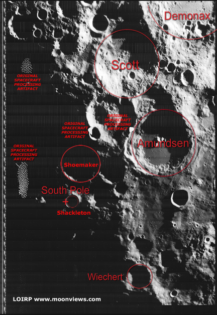
Figure 2 South Pole of the moon as seen by Lunar Orbiter IV with prominent features and processing artifacts identified (larger image)
This image has been recovered in its original high resolution format from original Lunar Orbiter project data tapes using restored tape drive hardware and will eventually be submitted to the PDS (Planetary Data System).
LOIRP Note: We will be putting the full resolution version of this image on the NASA Lunar Science Institute website with the layers preserved for Photoshop for all you folks to have fun with! We only ask that you send us copies of what you do and credit us if you publish it anywhere.
For more information on the Lunar Orbiter Image Recovery Project (LOIRP) visit https://moonviews.wpenginepowered.com
For information on NASA’s Lunar Science Institute visit http://lunarscience.arc.nasa.gov/
Presentation by Dennis Wingo on the Lunar Orbiter Image Recovery Project at the 2009 Apple WWDC
Lunar Orbiter Image Recovery Project (LOIRP) Releases New High Resolution Image of The Apollo 14 Landing Site With EVA Details
This photo (Frame 133-H2) of the future Apollo 14 landing site was taken by Lunar Orbiter III on 20 February 1967 at an orbital altitude of 46.7 km. The resolution of the image is around 0.8 meters per pixel. The area covered by this image is 4.52167 x 5.77666 km.
Figure 1 shows the image unlabeled. In Figure 2 we have overlaid the EVA route upon this image so as to show where the crew set foot. While the crew were supposed to visit Cone crater they stopped 20 meters short of doing so due to some confusion as to their exact location. That said, they did visit some large rocks located adjacent to Cone crater’s rim. The enlargement of this Lunar Orbiter image clearly shows some large rocks poised near the crater’s rim. The inset photo shows the largest outcropping as photographed by the crew on the surface.
NOTE: We originally posted these files in an incorrect orientation. This was due to how the images originally show up when they are retrieved from the original tapes. Thanks to all of you eagle-eyed viewers we caught that. We have replaced those earlier files with ones that are correctly oriented to North, South, East, and West.
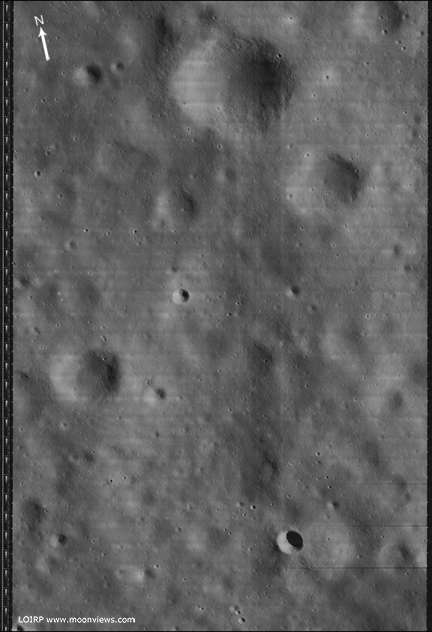
Figure 1 Lunar Orbiter III Frame 133-H2 unlabeled [larger view]
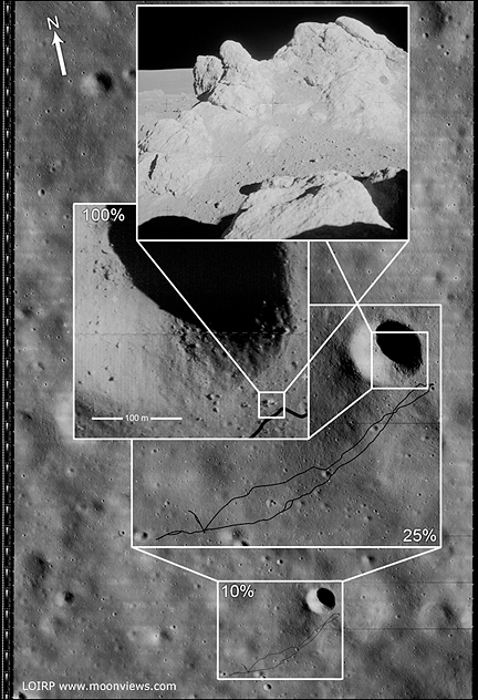
Figure 2 Lunar Orbiter III Frame 133-H2 labeled to show EVA route. [larger view]
This image has been recovered in its original high resolution format from original Lunar Orbiter project data tapes using restored tape drive hardware and will eventually be submitted to the PDS (Planetary Data System). The full resolution is online here at NLSI.
LOIRP Note: We will be putting the full resolution version of this image on the NASA Lunar Science Institute website with the layers preserved for Photoshop for all you folks to have fun with! We only ask that you send us copies of what you do and credit us if you publish it anywhere.
For more information on the Lunar Orbiter Image Recovery Project (LOIRP) visit https://moonviews.wpenginepowered.com
For information on NASA’s Lunar Science Institute visit http://lunarscience.arc.nasa.gov/
Related Links
Apollo 14 Surface Operations Overview
Apollo 14 Preliminary Science Report
Apollo 14 Mission Report
Apollo 14 Lunar Surface Journal
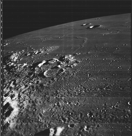
Lunar Orbiter Image Recovery Project (LOIRP) Releases New High Resolution Image of the Ocean of Storms
Larger version
The Lunar Orbiter Image Recovery Project (LOIRP) has released a newly-retrieved, high resolution image taken of the lunar surface 42 years ago.
This image was taken by Lunar Orbiter III (LPI data) in February 1967. This oblique photo shows the region around the crater Galilaei and Planitia Descensus in Oceanus Procellarum (the Sea of Storms). In the upper center of the image you can see the Great Wall of Procellarum.
This image has been recovered in its original high resolution format from original Lunar Orbiter project data tapes using restored tape drive hardware and will eventually be submitted to the PDS (Planetary Data System).
LOIRP Note: We will be putting the full resolution version of this image on the NASA Lunar Science Institute website with the layers preserved for Photoshop for all you folks to have fun with! We only ask that you send us copies of what you do and credit us if you publish it anywhere.
For more information on the Lunar Orbiter Image Recovery Project (LOIRP) visit https://moonviews.wpenginepowered.com
For information on NASA’s Lunar Science Institute visit http://lunarscience.arc.nasa.gov/
Apple WWDC Lunchtime Session: Dennis Wingo of the Lunar Orbiter Image Recovery Project (LOIRP)
Thursday 12 June 2009: noon: Come hear Dennis Wingo of the Lunar Orbiter Image Recovery Project (LOIRP) discuss their use of Mac OS X technology to save our Space Race heritage. LOIRP is retrieving, digitizing and publishing high-resolution pictures of the Moon captured by five NASA space probes ahead of the Apollo 11 moon landings in 1969. These tapes – rescued from destruction by a determined NASA archivist – represent some of the highest-resolution pictures ever taken of the Moon’s surface and are a priceless piece of history.
More info at http://developer.apple.com/wwdc/sciencemedicine/
LOIRP Releases Lunar Orbiter Ranger 8 Impact Crater Image
The Lunar Orbiter II-070-H image (Frame 70, High resolution) has a unique feature that is relevant to the LCROSS mission. This image shows the impact site of the Ranger 8 mission. This location was identified decades ago and is discussed in the NASA SP-168 online address. This location was also photographed during the Apollo 16 mission (NASA SP-315 page 29-46) but at a lower resolution of 3-5 meters. The image was taken from an altitude of 45.81 km. The resolution is about 0.4 meters per pixel. The crater from the Ranger impact is not well defined in the existing film database, especially as it appears at the boundary between two framelets.
Figure 1 is the reproduced trajectory of the Ranger 8 mission from NASA SP-168:

Figure 1: Ranger 8 Impact Trajectory Overlay on LOII-070-H (NASA SP-168). Image credit: LOIRP
Click on image to enlarge
Figure 2 shows the detail of the projected impact point:

Figure 2: Ranger 8 Estimated Impact Point (Crater C1). Image credit: LOIRP. Click on image to enlarge
The scale of an entire framelet is ~200 meters. While the full framelet is not shown here, the ragged overlap between two framelets from the film version of the image has lead to a misleading conclusion regarding the size and the shape of the crater. Crater C1 was disputed as the location of the impact in another NASA document (SP-315). The Apollo 16 preliminary science report (SP-315) identifies crater C2 as the impact point of Ranger 8 because it is consistent with other craters photographed by the later Apollo missions. The central mound is a distinctive signature of these impacts. Figure 3 is a low resolution version of our updated image from the LOIRP scans. The full resolution image [2.9 GB tiff] can be downloaded here

Figure 3: LOIRP LOII-70-H Image (reduced resolution). Image credit: LOIRP. Click on image to enlarge
Figure 4 shows the enhanced detail available from the LOIRP analog data tapes. Since the contrast is muted due to the nature of the site, the dynamic range improvements are not as noticeable. In the digital domain the framelet edges can be repositioned to generate a super-resolution version of the image by scanning the tape multiple times. The central mound, which seems to be an indicator of these small craters (as discussed in NASA SP 315 for the SIV-B impacts) is clearly evident here. The dark surrounding ejecta blanket was not expected, which drove the early identification of crater C1 as the impact point. However, it is unclear if the light colored ejecta to the lower left is associated with crater C1 or C2.

Figure 4: Detail of LOII-070-H2-f-601-602. Image credit: LOIRP. Click on image to enlarge
From a science perspective we are able to discern the size of the crater to a precise number (12.5 meters), which can give the LCROSS team a ground truth for similarly sized spacecraft.
Posted by: Soderman/NLSI Staff Source: D. Wingo/ LOIRP
LCROSS Citizen Science

The Lunar Crater Observation and Sensing Satellite (LCROSS) will excavate the permanently dark floor of one of the Moon’s polar craters with two heavy impactors in 2009 to test the theory that ancient ice lies buried there. The impact will eject material from the crater’s surface and subsurface to create a plume that specialized instruments will be able to analyze for the presence of water (ice and vapor), hydrocarbons and hydrated materials. Mission scientists estimate that the Centaur impact plume may be visible through amateur-class telescopes with apertures as small as 10 to 12 inches. As the mission progresses, this site will provide the general public, classrooms, and the amateur astronomy community details on how to observe the impact. The LCROSS mission will actively solicit images of the impact from the public. These images will provide a valuable addition to the archive of data chronicling the impact and its aftermath. This site will include a gallery of images received from both the public and professional communities. [More]