
 Die Mondschatz-Jäger, Der Speigel
“O schwöre nicht beim Mond, dem wandelbaren, der immerfort in seiner Scheibe wechselt, damit nicht wandelbar dein Lieben sei!”, weist bei Shakespeare die Julia ihren Romeo an. Wie Recht Julia mit dieser Aussage über die wandelbare Oberfläche des Erdtrabanten hatte, zeigt gerade eine Handvoll Wissenschaftler im kalifornischen Mountain View. Sie haben sich der alten Magnetbänder angenommen, auf denen die Nasa in den sechziger Jahren die ersten Aufnahmen von der Mondoberfäche speicherte. Und umgekehrt vom blauen Planeten aus der Mondperspektive.”
Saving Old Data
How Data Dies (and How It Can Be Saved), Gizmodo
“What we’re talking about is digital rot–or data rot or bit decay or whatever you’d like to call it–systemic processes which can mean death to data. Kind of a problem when you’d like to keep it around forever. Let’s paint this in broad strokes: You can roughly break the major kinds of rot into hardware, software and network. That is, the hardware that breaks down, the formats that go extinct, and the online stuff that vanishes one way or another.”
Lunakhod 2 Found
 Western researcher solves 37-year old space mystery, University of Western Ontario
“A researcher from The University of Western Ontario has helped solve a 37-year old space mystery using lunar images released yesterday by NASA and maps from his own atlas of the moon. Phil Stooke, a professor cross appointed to Western’s Departments of Physics & Astronomy and Geography, published a major reference book on lunar exploration in 2007 entitled, “The International Atlas of Lunar Exploration.”
Fly Over The Moon
Videos: New Lunar Images and Data Available to the Public
The public can follow along with NASA on its journey of lunar discovery. On March 15, the publicly accessible Planetary Data System will release data sets from the seven instruments on board NASA’s Lunar Reconnaissance Orbiter.
Dumpster Diving for Science
 NASA Dives Into Its Past to Retrieve Vintage Satellite Data, Science (subscription)
“Last month, researchers working out of an abandoned McDonald’s restaurant on the grounds of NASA Ames Research Center recovered data collected by NASA’s Nimbus II satellite on 23 September 1966. The satellite soared over Earth in a polar orbit every 108 minutes, taking pictures of cloud cover and measuring heat radiated from the planet’s surface, and creating a photo mosaic of the globe 43 years ago. The resulting image is the oldest and most detailed from NASA’s Earth-observing satellites. It’s also the latest success story in what researchers call techno-archaeology: pulling data from archaic storage systems. Once forgotten and largely unreadable with modern equipment, old data tapes are providing researchers with new information on changes in the surfaces of Earth and the moon…”
… The LOIRP team obtained $750,000 from NASA and private enterprise and enlisted the assistance of a retired Ampex engineer. They cleaned, rebuilt, and reassembled one drive, then designed and built equipment to convert the analog signals into an exact 16-bit digital copy. “It was like dumpster diving for science,” says Cowing, co-team leader at LOIRP. In November 2008, the team recovered their first image: a famous picture of an earthrise taken by Lunar Orbiter 1 on 23 August 1966. The team’s new high-resolution version was so crisp and clear that it revealed many previously obscured details, such as a fog bank lying along the coast of Chile. “We thought if the Earth’s surface looks that good a quarter of a million miles away, what does the moon’s surface look like 100 miles beneath it?” says Cowing.”
Click on image to enlarge


Nimbus II and Lunar Orbiter 1 Imagery: A New Look at Earth in 1966
 On 23 August 1966, the Lunar Orbiter 1 spacecraft took a photo of the Earth as seen from lunar orbit. This image, albeit grainy, quickly became an icon of the Space Age. This “earthrise” photo, while spectacular at the time, was never retrieved and processed to the full level of detail contained in the image. This was due in great part of the available technology at the time. Computer image processing was in its infancy.
Forty two years later, the Lunar Orbiter Image Recovery Project (LOIRP) managed to retrieve the image from original data tapes using restored tape drives from the 1960s. In so doing the level of detail present in the image was unparalleled. Subsequently, other images have been retrieved with the ultimate goal of obtaining all of the images returned by the five Lunar Orbiters.
One of the striking aspects of this newly enhanced image is the amount of detail that can be seen on Earth at a resolution of perhaps 1 km/pixel taken from a quarter of a million miles away. Among the details visible is the extent of the southern polar ice cap.
The LOIRP required a lot of what has come to be called “techoarchaeology” that is, going back in time to the original data and recording devices, using modern enhancements. The expertise gained by the LOIRP team eventually caught the attention of the folks at the National Snow and Ice Data Center (NSIDC).
Data from the Nimbus weather and earth observation satellite – in orbit at the same time as the Lunar Orbiters were circling the Moon – had languished for years in the national archives until John Moses NASA Goddard Space Flight Center had them digitized.
Dr. Walt Meir of the National Snow and Ice Data Center, after seeing the work that the LOIRP team had done in potentially identifying the Antarctic sea ice in the Lunar Orbiter 1 Earthrise image, and recognizing the similarity between the raw data of the Nimbus and Lunar Orbiter data, provided a grant to the LOIRP team to process the Nimbus data into a modern format and to correct image artifacts that are common to both types of images.
The LOIRP team accomplished this, and rendered the images into the Google Earth format using a variety of internally developed techniques and elements of the NASA Ames developed NASA World Wind Java software development kit.
To date some of the images taken by Nimbus II have been enhanced and mapped into Google Earth. One date in particular was of interest to the LOIRP – 23 August 1966. As the images were enhanced and dropped into Google Earth it became clear that we have imagery that overlapped in time to show the weather on that late August day as evening crept up on Africa and Europe.
In New York City, just over the Earth’s limb as seen from lunar orbit, the Beatles were preparing to play at Shea Stadium …
You can download a KMZ file of these images here for viewing in Google Earth.
Related Links
– Techno-Archaeology Rescues Climate Data from Early Satellites
– LOIRP Aids In Finding Google Earth Images from 1966
– Newly Restored Lunar Orbiter Image of Earth and Moon (Detail)
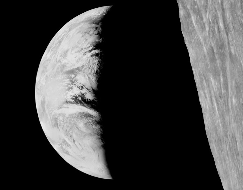
The original Lunar Orbiter 1 image of Earth on 23 August 1966 (click on image to enlarge)

Nimbus II imagery of Earth on 23 August 1966 (click on image to enlarge)

Overlap of Nimbus II imagery onto Lunar Orbiter 1 imagery (click on image to enlarge)