
This newly retrieved high resolution image, frame 3085_H1, was taken by Lunar Orbiter 3 on 18 February 1967 at 04:03 GMT LPI reference. Images: [large at LOIRP] [Very Large at NASA NLSI]

Official website of the Lunar Orbiter Image Recovery Project (LOIRP)
This newly retrieved high resolution image, frame 3085_H1, was taken by Lunar Orbiter 3 on 18 February 1967 at 04:03 GMT LPI reference. Images: [large at LOIRP] [Very Large at NASA NLSI]

This newly retrieved high resolution image, frame 3166_H3, was taken by Lunar Orbiter 3 on 21 February 1967 at 11:59 GMT LPI reference. Images: [large at LOIRP] [Very Large at NASA NLSI]. Note: the large white, arc-shaped features are processing artifacts – film flaws – from the automated film development process aboard Lunar Orbiter 3 in lunar orbit.

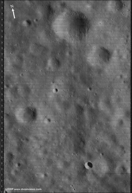
This image (LO3_194_H3) was taken by Lunar Orbiter III on 22 February 1967 at 5:24:14 GMT at an altitude of 54.27 km above the lunar surface. High resolution frame 3 clearly shows the Surveyor 1 spacecraft sitting on the lunar surface complete with a long shadow.
Surveyor 1 landed on the Moon on 2 June 1966 in the Ocean of Storms (Oceanus Procellarum) at 2.45 degrees South latitude, 43.22 degrees West longitude.

Larger view
This image has been recovered in its original high resolution format by LOIRP staff from original Lunar Orbiter project data tapes using restored tape drive hardware and will eventually be submitted to the PDS (Planetary Data System).
A full resolution version of this image will be placed online at the NASA Lunar Science Institute.
The Lunar Orbiter Image Recovery Project (LOIRP) is located at the NASA Ames Research Center in Moffett Field, CA. Funding and support for this project has been provided by NASA Exploration Systems Mission Directorate, NASA Innovative Partnerships Program, NASA Lunar Science Institute, NASA Ames Research Center, Odyssey Moon LLC, SkyCorp Inc., and SpaceRef Interactive Inc.
For more information on the Lunar Orbiter Image Recovery Project (LOIRP) visit https://moonviews.wpenginepowered.com
For information on NASA’s Lunar Science Institute visit http://lunarscience.arc.nasa.gov/
For information on NASA’s Exploration Systems Mission Directorate visit http://www.nasa.gov/exploration/
Surveyor I: Location and Indentification, Science
Science 11 August 1967: Vol. 157 no. 3789 pp. 681-684
DOI: 10.1126/science.157.3789.681
L. Harold Spradley, R. Steinbacher, M. Grolier, C. Byrne
Surveyor I landed on the lunar surface on 2 June 1966 and obtained more than 11,000 pictures of the environment with its television camera. The same region was photographed by the 24-inch (61-centimeter) camera of Orbiter III on 22 February 1967. Surveyor I has been located in these Orbiter photographs; its image was found and all search and identification criteria were satisfied by the site.
Related Document
Lunar coordinates of Surveyor 1, Charles J. Byrne, 28 April 1967

Yesterday the LRO team released a new image of the Apollo 14 landing site. You can clearly make out the paths that the crew walked as well as the location of the Apollo 14 Antares Lunar Module Descent Stage.
In June 2009 LOIRP issued its own view and analysis of this landing site – as seen by Lunar Orbiter III back in 1967.
Comparing our high resolution image of the site with that taken by LRO clearly shows no feature where Antares’ Descent Stage now stands [larger image]. While the resolution of the Lunar Orbiter image (0.8 meters/pixel) would probably not reveal astronaut tracks in great detail, we’re rather certain that it would have seen an object the size of Antares’ Descent Stage.
As such, we’re pretty certain that the Apollo 14 mission landed on the Moon!
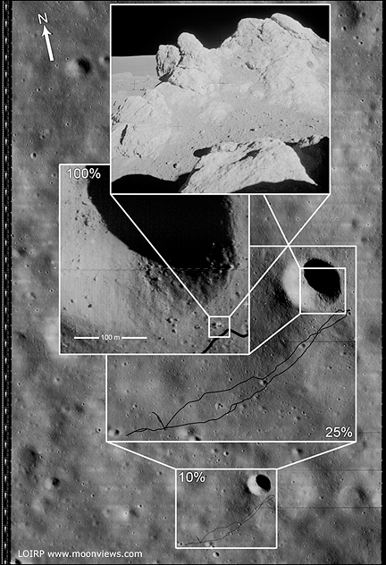
This photo (Frame 133-H2) of the future Apollo 14 landing site was taken by Lunar Orbiter III on 20 February 1967 at an orbital altitude of 46.7 km. The resolution of the image is around 0.8 meters per pixel. The area covered by this image is 4.52167 x 5.77666 km.
Figure 1 shows the image unlabeled. In Figure 2 we have overlaid the EVA route upon this image so as to show where the crew set foot. While the crew were supposed to visit Cone crater they stopped 20 meters short of doing so due to some confusion as to their exact location. That said, they did visit some large rocks located adjacent to Cone crater’s rim. The enlargement of this Lunar Orbiter image clearly shows some large rocks poised near the crater’s rim. The inset photo shows the largest outcropping as photographed by the crew on the surface.
NOTE: We originally posted these files in an incorrect orientation. This was due to how the images originally show up when they are retrieved from the original tapes. Thanks to all of you eagle-eyed viewers we caught that. We have replaced those earlier files with ones that are correctly oriented to North, South, East, and West.
This image has been recovered in its original high resolution format from original Lunar Orbiter project data tapes using restored tape drive hardware and will eventually be submitted to the PDS (Planetary Data System). The full resolution is online here at NLSI.
LOIRP Note: We will be putting the full resolution version of this image on the NASA Lunar Science Institute website with the layers preserved for Photoshop for all you folks to have fun with! We only ask that you send us copies of what you do and credit us if you publish it anywhere.
For more information on the Lunar Orbiter Image Recovery Project (LOIRP) visit https://moonviews.wpenginepowered.com
For information on NASA’s Lunar Science Institute visit http://lunarscience.arc.nasa.gov/
Related Links
Apollo 14 Surface Operations Overview
Apollo 14 Preliminary Science Report
Apollo 14 Mission Report
Apollo 14 Lunar Surface Journal
 Alternate Names: Lunar Orbiter-C, 02666
Launch Date: 1967-02-05
Launch Vehicle: Atlas-Agena D
Launch Site: Cape Canaveral, United States
Mass: 385.6 kg
Nominal Power: 375.0 W
Launch/Orbital information for Lunar Orbiter 3
Experiments on Lunar Orbiter 3
Data collections from Lunar Orbiter 3
Description
The Lunar Orbiter 3 spacecraft was designed primarily to photograph areas of the lunar surface for confirmation of safe landing sites for the Surveyor and Apollo missions. It was also equipped to collect selenodetic, radiation intensity, and micrometeoroid impact data. The spacecraft was placed in a cislunar trajectory and injected into an elliptical near-equatorial lunar orbit on 8 February at 21:54 UT. The orbit was 210.2 km x 1801.9 km with an inclination of 20.9 degrees and a period of 3 hours 25 minutes. After four days (25 orbits) of tracking the orbit was changed to 55 km x 1847 km. The spacecraft acquired photographic data from February 15 to 23, 1967, and readout occurred through March 2, 1967. The film advance mechanism showed erratic behavior during this period resulting in a decision to begin readout of the frames earlier than planned. The frames were read out successfully until 4 March when the film advance motor burned out, leaving about 25% of the frames on the takeup reel, unable to be read.
The Lunar Orbiter 3 was a spacecraft launched by NASA in 1967, designed primarily to photograph areas of the lunar surface for confirmation of safe landing sites for the Surveyor and Apollo missions. It was also equipped to collect selenodetic, radiation intensity, and micrometeoroid impact data. The spacecraft was placed in a cislunar trajectory and injected into an elliptical near-equatorial lunar orbit on February 8 at 21:54 UT. The orbit was 210.2 by 1,801.9 kilometres (130.6 1,119.6 mi) with an inclination of 20.9 degrees and a period of 3 hours 25 minutes. After four days (25 orbits) of tracking the orbit was changed to 55 by 1,847 kilometres (34 1,148 mi). The spacecraft acquired photographic data from February 15 to February 23, 1967, and readout occurred through March 2, 1967.


