
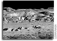
 The Lunar Orbiter Image Recovery Project (LOIRP) has released another iconic image taken during the Lunar Orbiter program in the 1960’s. This image, which shows the dramatic landscape within the crater Copernicus was often referred to as the “picture of the century” by many people at the time of its original public release in 1966.
This image was taken by the Lunar Orbiter 2 spacecraft at 7:05 p.m. EST on 24 November 1966 from an altitude of 28.4 miles above the lunar surface, 150 miles due south of Copernicus. At the time this image was originally released most views of the lunar surface involved looking straight down. Little, if any, sense of the true elevation of lunar surface features was usually available. This photo changed that perception by showing the Moon to be a world with tremendous topography – some of it Earth-like, much of it decidedly un-earth-like.
According to Wikipedia: “In 1966 the crater was photographed from an oblique angle by Lunar Orbiter 2 as one of 12 “housekeeping” pictures that were taken to advance the roll of film between possible astronaut landing sites being surveyed. At the time this detailed image of the lunar surface was termed by NASA Scientist Martin Swetnick and subsequently quoted by Time magazine as “one of the great pictures of the century.”
Time magazine said (“A New Look at Copernicus“): “Except for the black sky in the background, the photograph might have been mistaken for a composite of the scenic grandeur of Grand Canyon and the barren desolation of the Badlands of South Dakota. But when it was flashed unexpectedly onto a screen at a meeting of the American Institute of Aeronautics and Astronautics in Boston last week, sophisticated space scientists and engineers recognized the terrain immediately. It was a spectacular close up shot of lunar landscape. That photograph of the moon’s Crater of Copernicus, said NASA Scientist Martin Swetnick, is “one of the great pictures of the century.”
The following image is an interim version, with reprocessing and enhancements being made constantly. A larger, raw version (2.2 GB in size) is now online at NASA’s Lunar Science Institute. Larger view.
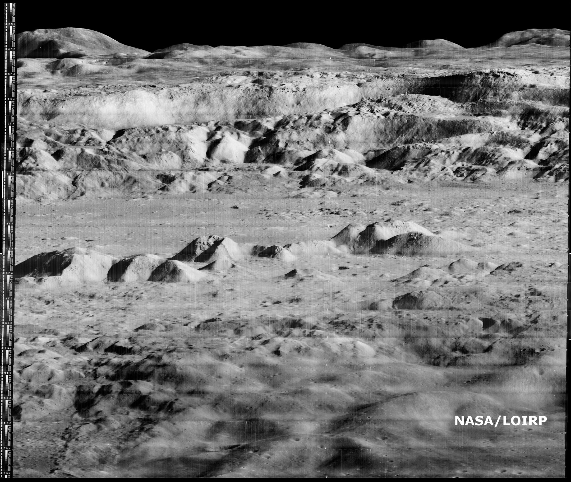
If you compare this new image with LPI’s high res version you can clearly see that this new image shows multiple striations in the surface, small boulders, landslides, shadows and a myriad of fine details simply not visible in the original. The LOIRP currently estimates that the resolution of this image is less than 1 meter/pixel. Larger view.
Dennis Wingo, co-lead of the LOIRP will make a presentation on this image and the LOIRP at the Lunar and Planetary Science Conference on Monday, 23 March 2009 at 8:30 am (session 102)
The LOIRP, funded by NASA’s Exploration Mission Systems Directorate and NASA’s Innovative Partnership’s Program, with support from Odyssey Moon, Skycorp Inc., SpaceRef Interactive Inc., ACES, and the NASA Lunar Science Institute, is housed at NASA Ames Research Center at Moffet Field, CA. This project has utilized original analog data tapes and restored tape drives to digitize original Lunar Orbiter project imagery. Utilizing computer technology unavailable at the time the images were originally taken, LOIRP has been able to produce images which greatly exceed the resolution of the images as they were first seen in 1966 and 1967.
The first image released by the LOIRP, the famous “earthrise image”, was made public in November 2008. It is anticipated with the release of this latest image of Copernicus, and further restoration of the original 40 year old hardware, that the pace of additional image releases will now increase.
Further information on the LOIRP can be found at https://moonviews.wpenginepowered.com/
You can follow our image restoration process on Twitter at LunarOrbiter
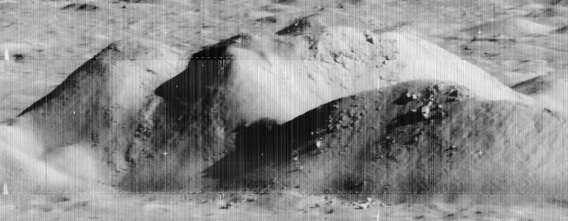
It looks like there are AT LEAST three or four pieces of NON-LUNAR objects visible in the second picture on this page. Look at the blow up. These structures LOOK like some sort of towers as if to hold power lines. One on the the “nose” of the higher hill, then on the “chin” of the same hill, and then on the smaller hill..two the front slope, and then one higher up toward the top. There is also, something that LOOKS like a vehicle parked on the flat in front of the right lower slope. Can you indentify?
Editor’s note: everything you see is made out of moon rocks.
John,
The items that look like power-towers appear to be artifacts of the film/digital process.
If you take the one on the ‘chin’ of the higher hill and go straight down towards the bottom, an identical artifact appears on the ‘floor’ below the hill and you’ll notice it doesn’t cast a shadow.
Both are located near the boundary of their respective ‘scan-borders’.
I couldn’t make out the other items you mentioned – the thing that looks like a truck on the slope of the hill to the right could just as likely be a rock outcropping, everything is heavily shaded and we have a tendency to recognize objects through visual cues that correspond with personal familiarity.
Before Richard C. Hoagland or any of his wannabes take and run with this, it is very important to remember scale and resolution. I know it’s difficult to ask any conspiracy theorist to assume the altitude, distance, and resolution information provided in the article is accurate. Anyway, with this assumption, this image was taken from an altitude of 28.4 miles above the lunar surface, 150 miles due south of Copernicus and has an approx resolution of 1 meter/pixel. Anyone with half a wit would know that the resolution would have to be much, much better than 1 meter (3.37’)/pixel regardless of the zoom or magnification level to be able to distinguish any of the objects Stettler mentions unless that object was built on a large scale beyond belief or practicality. Heck, an entire population of thousands of humanoid figures standing together waving hello to the passing idiot craft would not be distinguishable as any shape individually or collectively. Their average color tone (let’s say they were green) would only lend itself to the overall image of the area they were massed, like a giant green blur.
Unfortunately, the 2,2 GB TIFF image can not be open on most computers. Please consider creating a file in a format JP2 (lossless option) like images produced by HIRSE team. In this case the size of the file does not play any role, the image can be displayed by the IAS Viewer on any computer.
you geeks really rock!
I was at JPL in SFOF when this image came in (yes, I am THAT old, although I was certainly a kid back then). Seeing these images recovered brings back such memories of those first steps towards the eventual Moon landings.
John, give it a rest. There is no intelligent life on the Moon or Mars. We cannot even find it in Washington DC. Just enjoy the scenery for what it is and the accomplishments of the men and women who built and flew the mission.
The mountains/hills on the top edge of the image (and to the right a little) look like they’re overlaid at partial transparency on top of other hills (on lo2.copernicus.med.jpg). Zoomed to 100% it’s obvious, can anyone explain what this is? Could it be a portion of another image overlaid on accident?
Great photos. Would it be possible to also remove striations – basically do some combination of de-biasing or flat-fielding?