Lunar Orbiter Tracking Stations


Dennis Wingo: We often talk about the ground stations for Lunar Orbiter. Here is a chart that shows the coverage of the DSIF (Deep Space Instrumentation Facility) the precursor of the Deep Space Network (DSN). for Woomera, Goldstone, and Johannesburg. In 1965 when this graphic was created, the Madrid station was still under construction. You can see the overlap between Woomera and Goldstone quite clearly. Out to lunar distance the overlap is even greater. Larger image.

How Life Magazine Revealed “Earthrise” in 1966

The following two pages from the 9 September 1966 issue of Life magazine are how many people first saw the famous “earthrise” photo taken by Lunar Orbiter 1 less than two weeks earlier. The editors of Life sought to place the image in a context such that people could see what was actually in the picture. LOIRP has done similar analyses here and here. Due to the enhanced resolution of our images we were able to pin down the exact time and orientation of Earth a bit more accurately than was possible in 1966.
Click on images to enlarge.


LOIRP analysis in 2008

Boeing Planetary Probe Concept Based on Lunar Orbiter Design

“This is an artist’s impression of how an unmanned would look as it neared Mars before going into a the planet. The Boeing Company has proposed building such a spacecraft, using technology developed during the successful Lunar Orbiter program. It would carry automatic equipment for taking, developing and sending back to Earth close-up photos of our neighboring planets. The spacecraft would operate in orbit for about a year and could be used on missions to Mars or Venus.” Larger image.

Making the Lunar Orbiter Models

Our friend Andrew Filo of Special Projects from Cupertino, CA has the Lunar Orbiter models almost done for those who donated for the models as your prize. Thanks very kindly and they will be sent out in about a week. We are starting to get everything together for fulfillment of the items that you got for your donations. Looking forward to getting everything to you!

Lunar Orbiter’s Classified Heritage

SAMOS To The Moon: The Clandestine Transfer of Reconnaissance Technology Between Federal Agencies, NRO
“Having acquired, launched, and then terminated work on a near real time imaging satellite, however, NRO officials at that time agreed to consign the SAMOS imaging system to the National Aeronautics and Space Administration (NASA) for use in its deep space exploration program. The surreptitious transfer of this technology, a fact just recently declassified, has remained unknown to many in the NRO and NASA because of the compartmented security measures then in place. It occurred in the following manner.
When in the summer of 1963 NASA requested proposals for a five flight Lunar Orbiter imaging satellite, the Eastman Kodak Company asked for and received permission from the NRO to join The Boeing Airplane Company and bid on the program. In the effort to meet NASA requirements, Eastman would modify its E-1 camera with an 80mm focal length Schneider-Xenotar lens and an off-the-shelf 24-inch telephoto lens procured from Pacific Optical. The two lenses would be bore sighted at the surface of the moon for a planned orbit of about 30 miles altitude. Light would pass through each lens to the film, but the simultaneous images were interspersed with other exposures, and not placed side by side. The camera employed the existing velocity over height sensor to regulate the speed of the focal plane shutter on the 24 inch lens and the between the lens shutter on the 80mm lens, which compensated for image motion. The Boeing Airplane Company, in turn, designed a solar-powered spacecraft stabilized in attitude on three axes that mounted other off-the-shelf hardware, and integrated it with the modified E-1 SAMOS payload.”

Continue reading “Lunar Orbiter’s Classified Heritage”

Printing The Moon


Between 1966 and 1967 NASA sent five Lunar Orbiter spacecraft to the Moon. Their job was to survey the surface to help determine landing sites for the upcoming Apollo missions. In addition to their recon role, these spacecraft also contributed to the nascent scientific understanding of the Moon.
At the time that the images were taken using film that was actually developed aboard the spacecraft in lunar orbit, the ability to send back imagery was nothing like it is today. The photos were scanned much like news photos of the day and the data was sent back to Earth. The images were then printed out on photographic paper and used to construct maps of the lunar surface. In so doing a lot of data from the original photos was lost. Luckily NASA had the foresight to listen to the suggestions of project engineers such as Charles Byrne and stored the original data on analog tapes.
Some 40 years after these missions were completed the Lunar Orbiter Image Recovery Project (LOIRP) was begun with the intent of using refurbished tape drives and a complete set of original project tapes (over 1,500). Utilizing funding from NASA the LOIRP team was able to return the original drives to operation such that the data on the tapes could be accessed.
By adding modern computer interfaces and data handling techniques, the LOIRP was able to scan and record the data in ways that simply could not have been accomplished in the 1960s. As a result the images that were obtained had a much higher resolution and dynamic range than had been seen to date. Indeed, in many cases, these images often rival or exceed images taken by the Lunar Reconnaissance Orbiter which is currently surveying the Moon.
As clever as we thought we were, we were not the first team to tackle the issue of generating high resolution imagery. Someone tried to do much of what we were doing today – but did so with technology available in the 1960s. We were recently contacted by someone who had seen our project’s Facebook page. His name is Joe Watson and he worked on a project that used computer printers that worked like giant electric typewriters – but using varying sizes of squares instead of letters. With this system and a lot of creativity, Watson and his team created immense high resolution versions of Lunar Orbiter images from which topographic maps were made.
We had heard some vague stories about such projects but were unaware of just how audacious they were. So, in Joe Watson’s own words, here is the story of a precursor of the LOIRP.

Continue reading “Printing The Moon”

Iconic Lunar Orbiter Image of Copernicus Re-released


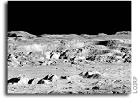
Today an iconic image from the initial exploration of the Moon is being re-released showing detail that could not have been seen using technology available at the time the photo was taken. This image features a dramatic view inside the majestic crater Copernicus – a view that left millions in awe when it was first released.
This image was announced at the First Global Space Exploration Conference, co-sponsored by the AIAA and IAF, in Washington, DC.
Between 1966 and 1967 NASA sent five Lunar Orbiter spacecraft to the Moon. Their job was to survey the surface to help determine landing sites for the upcoming Apollo missions. In addition to their recon role, these spacecraft also contributed to the nascent scientific understanding of the Moon. But every once in a while these spacecraft also served as artists, snapping photos of this nearby world in a way that human eyes had never been able to see before.
Once such image was taken of crater Copernicus on 24 November 1966 by the Lunar Orbiter 2 spacecraft. What made this photo so unique was the oblique angle it was taken at as well the close proximity of the spacecraft to its target. The image was taken at an altitude of 45 km (27.1 miles) at a distance of approximately 207.7 km (~125 miles) from the center of the crater. Instead of looking down, the spacecraft looked sideways at the Moon.
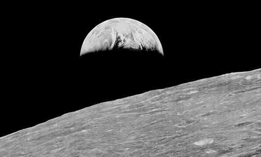
For the first time people saw the Moon as a world with mountains and boulders and other features (some of them strange) that were not apparent from photos where the view was looking straight down. So taken were people at the time that Life Magazine took to calling the photo “The Picture of the Century”. Along with the equally famous Earthrise image taken by Lunar Orbiter 1, the Moon went from being a distant sight in the sky to a world waiting to be explored – in person.

At the time that the images were taken using film that was actually developed aboard the spacecraft in lunar orbit, the ability to send back imagery was nothing like it is today. The photos were scanned much like news photos of the day and the data was sent back to Earth. The images were then printed out on photo graphic paper and used to construct maps of the lunar surface. In so doing a lot of data from the original photos was lost. Luckily NASA had the foresight to listen to the suggestions of project engineers such as Charles Byrne and stored the original data on analog tapes.
Some 40 years after these missions were completed the Lunar Orbiter Image Recovery Project (LOIRP) was begun with the intent of using refurbished tape drives and a complete set of original project tapes (over 1,500). Utilizing funding from NASA, facilities offered by NASA Ames Research Center, and donated effort and resources from SkyCorp Inc. and SpaceRef Interactive Inc., the LOIRP team was able to return the original drives to operation such that the data on the tapes could be accessed.
By adding modern computer interfaces and data handling techniques, the LOIRP was able to scan and record the data in ways that simply could not have been accomplished in the 1960s. As a result the images that were obtained had a much higher resolution and dynamic range than had been seen to date. Indeed, in many cases, these images often rival or exceed images taken by the Lunar Reconnaissance Orbiter which is currently surveying the Moon.
In 2009 LOIRP released its first attempt to retrieve this image of Copernicus. In the ensuing several years the process of calibrating thee tape drives, scanning the tapes, and assembling and processing the imagery has improved to the point that a new attempt to retrieve the image was undertaken.
This project is multi-generational in many ways. The tape drives use original parts and modern components and are connected to monitoring equipment that is itself decades old. All of this is connected to Mac desktop computers running of the shelf software. There are some special tools. Some of the software LOIRP now uses to process these images was written by Charles Byrne – the very same person who suggested that these images be stored on data tapes over 40 years ago.
LOIRP also involves the participation of young people such as Austin Epps and Neulyn Moss in the process of generating and analyzing the images. LOIRP also has a regular series of local students working as interns to assist the project.
It is important to remember that as we look toward the Moon, Mars and other places as future destinations that we are not the first generation to do so. In the 1960s people had the same dreams – and they acted upon them with simpler tools than we have today. There is a lot to be gained from talking to people from that era. They have more than just memories of these days. Unlike many of us today, they know how to actually make their dreams become reality. That advice is timeless and is something that needs to be passed on to a new generation. We take it very seriously at LOIRP. Indeed, had we not done so, we’d never have retrieved these images.
About LOIRP
The Lunar Orbiter Image Recovery Project (LOIRP) is located at the NASA Research Park at Moffett Field, CA. Funding and support for this project has been provided by the NASA Human Exploration Operations Mission Directorate, the NASA Innovative Partnerships Program, the NASA Lunar Science Institute, NASA Ames Research Center, SkyCorp Inc., and SpaceRef Interactive Inc.
For more information on the Lunar Orbiter Image Recovery Project (LOIRP) visit https://moonviews.wpenginepowered.com
For information on NASA’s Lunar Science Institute visit http://lunarscience.arc.nasa.gov/

IMAGES

Image: This is the newly reprocessed view of Copernicus. (larger image) (Raw image 683.2MB LINK NOT WORKING) Credit: LOIRP

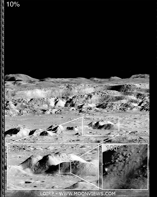
Image: This image shows the magification that is possible with the LOIRP image recovery process (larger image) Credit: LOIRP

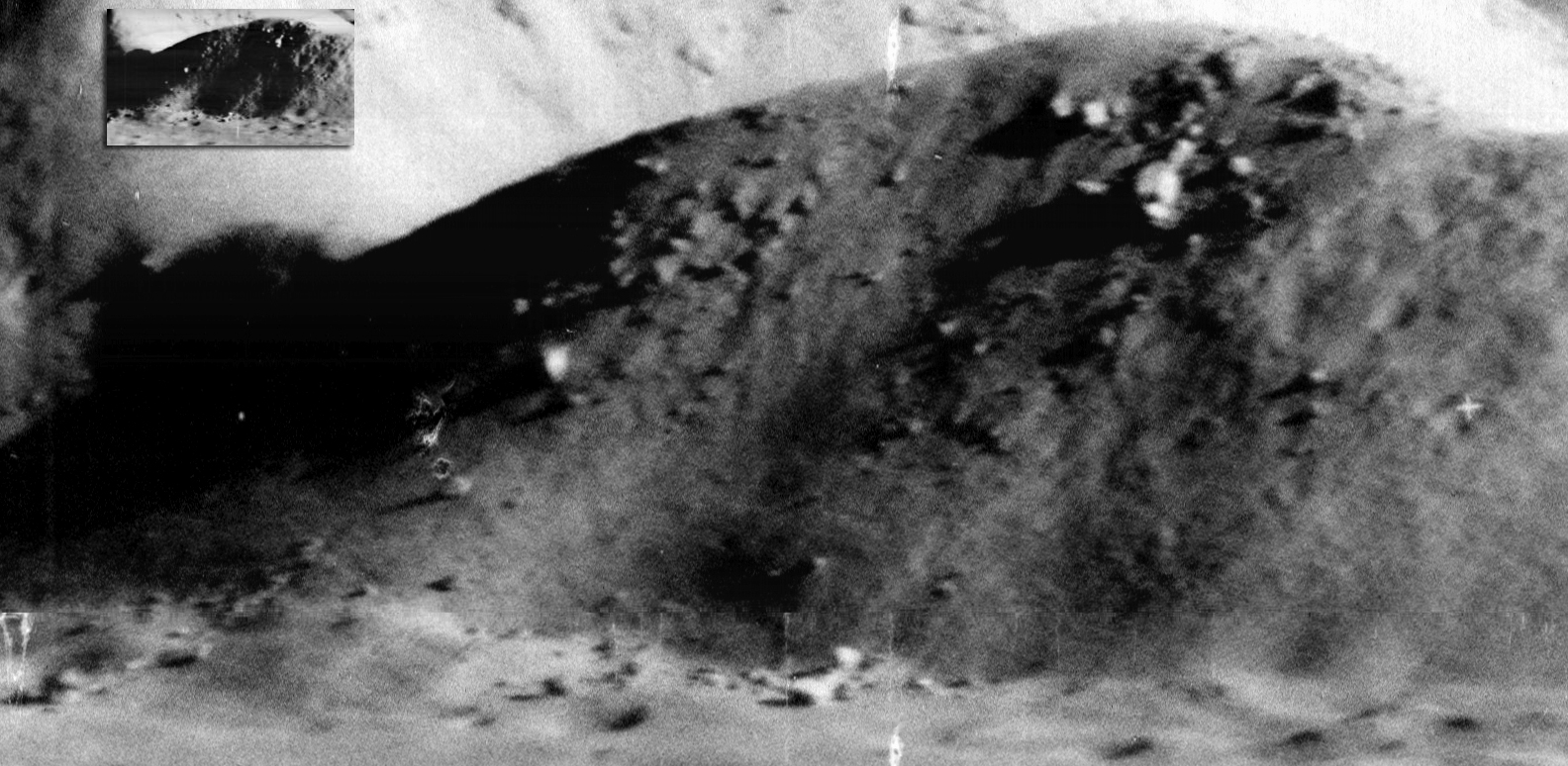
Image: If you take the highest resolution image that is available on the LPI Lunar Orbiter site and compare it with the new LOIRP image, the increase in size becomes obvious. Credit: LOIRP

Image: The amount of detail that the new image reveals is clear. Not only is the resolution much higher, but the dynamic range is greater so as to allow gradations in surface texture, shadows, etc. to be much more clearly pronounced (larger image). Credit: LOIRP