
Larger version
The Lunar Orbiter Image Recovery Project (LOIRP) has released a newly-retrieved, high resolution image taken of the lunar surface 42 years ago.
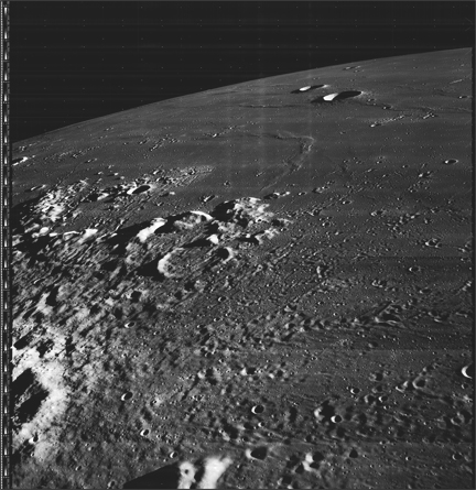
This image was taken by Lunar Orbiter III (LPI data) in February 1967. This oblique photo shows the region around the crater Galilaei and Planitia Descensus in Oceanus Procellarum (the Sea of Storms). In the upper center of the image you can see the Great Wall of Procellarum.
This image has been recovered in its original high resolution format from original Lunar Orbiter project data tapes using restored tape drive hardware and will eventually be submitted to the PDS (Planetary Data System).
LOIRP Note: We will be putting the full resolution version of this image on the NASA Lunar Science Institute website with the layers preserved for Photoshop for all you folks to have fun with! We only ask that you send us copies of what you do and credit us if you publish it anywhere.
For more information on the Lunar Orbiter Image Recovery Project (LOIRP) visit https://moonviews.wpenginepowered.com
For information on NASA’s Lunar Science Institute visit http://lunarscience.arc.nasa.gov/
It has always bugged me that there was banding in these images. Now that I’m a PhotoShop maven, I think it should be possible to recalibrate the images and flatten the banding out. The piece of blackness of space in the corner should suffice to get things started.
Thoughts?
Stunning. These photos continue to amaze me.
Is there somewhere on the site that explains in detail how these photos were taken? For example, why are the stars in the background repeated, both horizontally and vertically?
Richard Drumm:
It would be great to do some PS on these images. However, it is just a miracle that these images are even now in existance. The PS can come later on but I just think it was just a whole load of effort to just recover these gems, like a rough cut so to speak. They can be shaped later.
Congratulations to the image recovery team. You have done a fantastic job. Keep it up.
Beautiful work, folks. It really is like having an additional mission in orbit, every time LOIRP issues another release.
I will need to scratch my head a little to discover whether this shot from LO-III was imaged before or after the soft-landing of Luna 9, said to have descended and set down in Descendus, surrounded by what its cameras showed was a “plain,” though its public coordinates of 296E, 7N put it right in the middle of that craggy peninsula.
Maybe LRO can “resolve” that long dispute.
Another target to the North, just this side of Galilaei, should be the resting place of Luna 8, which may have soft-landed more than a year earlier, though contact was lost at or near landing.
A historic image, indeed.
Not much “head-scratching” was needed for me to suddenly remember, in my dim memory, Luna 9 soft-landed somewhere inside this field of view the same month a year earlier, in Feb. 1966.
Luna 9 images show a somewhat “rumpled” terrain, rather like Apollo 14 Fra Mauro terrain (Imbrium ejecta blanket) or the Cayley Planes of the Apollo 16 Descartes/Cayley southern highlands.
Luna 13 images, taken with a nearly identical camera (performing slightly better) show a flat mare surface like Apollo 11 and 12 and Surveyor 1 and 6 sites.
I’m convinced, proof to be supplied later, that Luna 16 landed in subdued nonmare terrain.
Adam
The “stars” that you are seeing are actually called Reseau marks and were pre exposed on the tape before flight to aid in putting the image together.