
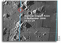
 SMART-1 Impact Site on the Moon
“On the morning of 3 September 2006, a brief flash illuminated the Moon’s ‘Lake of Excellence’ as ESA’s SMART-1 mission met its fate on the dusty surface. Launched in 2003, SMART-1 was the first European spacecraft to travel to and orbit the Moon. Short for Small Missions for Advanced Research in Technology, SMART-1 used ion propulsion to journey to the Moon, tested new techniques in communications and navigation, and carried a battery of miniaturised scientific instruments. It completed a comprehensive inventory of key chemical elements in the lunar surface, mapped impact craters, studied the volcanic and tectonic processes that shaped the Moon, and investigated sites for future exploration.”
SMART-1 Mapped Crash Scene of Upcoming LCROSS Impact
 The European Space Agency’s SMART-1 team has released an image of the future impact site of NASA’s Lunar Crater Observation and Sensing Satellite (LCROSS). LCROSS will search for water ice on the Moon by making two impacts into a crater named Cabeus A at the lunar South Pole. The impacts are scheduled for 11:30 am UT on 9 October 2009.
Bjoern Grieger, the liaison scientist for SMART-1’s AMIE camera, and Project Scientist Bernard Foing have searched through SMART-1’s database for images of Cabeus A, taken four years ago at conditions where solar elevation and direction were similar to those of LCROSS impact. The SMART-1 image is at high resolution as the spacecraft was at its closest distance of 500 km from the South Pole. The SMART-1 image of the LCROSS target was discussed last week at lunar sessions of the European Planetary Science Congress (EPSC) in Potsdam, Germany. More
The lunar north pole – SMART-1 mosaic
 A new map obtained with SMART-1 data shows the geography and illumination of the lunar north pole. Such maps will be of great use for future lunar explorers. The lunar poles are very interesting for future science and exploration of the Moon mainly because of their exposure to sunlight. They display areas of quasi-eternal light, have a stable thermal environment and are close to dark areas that could host water ice – potential future lunar base sites. More
SMART-1 maps its own impact site
 This mosaic of images, obtained by the Advanced Moon Imaging Experiment (AMIE) on board ESA’s SMART-1 spacecraft, shows the SMART-1 landing site on the Moon. AMIE obtained this sequence on 19 August 2006 from the relatively high distance of 1200 kilometres from the surface (far from the SMART-1 perilune, or point of closer approach), with a ground resolution of about 120 metres per pixel. The imaged area, located at mid-southern latitudes on the lunar near-side, belongs to the so-called ‘Lake of Excellence’. To take these images, SMART-1 had to be tilted by 20 degrees in order to obtain a large ground coverage and an image mosaic of several views, each covering an area about 60 kilometres per side. More