High School Team Tackles Lunar Mystery


Members of the 2011-12 Lunar Exploration Team: L-R Abby Delawder, Tori Wilson, and Austen Beason
When the Lunar Reconnaissance Orbiter relayed images in 2011 of oddly striped boulders on the moon – some of them a dozen or more meters across – three students at Kickapoo High School in Springfield, Missouri, in search of a class science project decided to investigate. They joined a 2-semester research program through the SSERVI’s Center for Lunar Science and Exploration in Houston, Texas.
With mentor Georgiana Kramer, a planetary scientist there, the team has now netted a scientific paper. The Kickapoo Lunar Research Team spent several months trying to explain the stripes. Researchers had already floated several possibilities.
Kramer suspected that the light-colored layers were probably regolith, material blasted from impact craters elsewhere on the moon. But the students found that such debris accumulates much too slowly to account for the banding. Through their calculations, they arrived at a new explanation: The striping formed as molten material cooled deep within the moon’s crust. “I was surprised at the answer they came up with,” Kramer says. But the team has support for the theory: Some banded rocks on Earth form by a similar process, says team member Abby Delawder. “These banded rocks are nothing like any other rocks found on the moon’s surface,” she notes. “It’s clear they were blasted upward by an impact.”
Unlike the average high school project, this one appeared among graduate student posters at NASA’s annual Lunar Science Institute Forum in Mountain View, California, in 2012 and will be published in a forthcoming issue of the journal Icarus.
Posted by: Soderman/SSERVI Staff Source: SSERVI Team/ Ref: SCIENCE, VOL 342, DECEMBER 6 2013

Lunakhod One Is Still In Its Parking Location


“Luna 17, carrying Lunokhod 1, landed on the flood basalt surface of Mare Imbrium on 17 November 1970, after entering orbit on 15 November. Today’s Featured Image of Luna 17 and Lunokhod 1 was obtained during a low altitude (33 km) pass providing the highest resolution view yet of the landing site.”

NASA LRO Image: Luna 23’s Rough Landing On The Moon

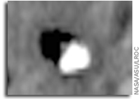
Unfortunately, Luna 23 experienced a malfunction and hit the surface at a very high velocity. Contact was maintained between Earth and the spacecraft after landing, but a sample could not be acquired. At the time, the cause of the failure was not known, but it seemed probable that the whole spacecraft tipped over upon landing at an unexpectedly high velocity. Indeed, the high resolution LROC NAC image (below) shows the spacecraft lying on its side!
More information and imagery.

NASA LRO Image: Sharper View of Apollo 12 Landing Site

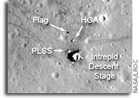
The Apollo 12 landing site in Oceanus Procellarum imaged during the second LRO low-altitude campaign. Image width is 225 m, NAC Image M175428601R [NASA/GSFC/Arizona State University].
The LRO mission continues to collect observations that are enabling ground-breaking new scientific discoveries about the Moon. As geologists, whenever we look at remotely sensed data collected from another planet, in a sense we are staring back in time. But this is the “deep time” of geology, where we are trying to understand natural processes that (at least on the Moon, anyway) could have happened billions of years ago. But the LRO mission is unique because we can also see human history. Not just any history, either, but one of humanity’s greatest accomplishments, our first steps on another world. Twelve astronauts explored the lunar surface, directly seeing things with their own eyes, making observations, and collecting samples with their own hands. These samples and observations revolutionized our understanding of our solar system.
This “snapshot in time” effect is especially evident at the Apollo 12 landing site in Oceanus Procellarum, now known as Statio Cognitum. Here, you can see the remnants of not one, but two missions to the Moon. Astronauts Pete Conrad and Alan Bean demonstrated that a precision lunar landing with the Apollo system was possible, enabling all of the targeted landings that followed. Bean and Conrad collected rock samples and made field observations, which resulted in key discoveries about lunar geology. They also collected and returned components from the nearby US Surveyor 3 spacecraft, which landed at this site almost two and half years previously, providing important information to engineers about the how materials survive in the lunar environment.
More

NASA LRO Image: A New View of the Apollo 11 Landing Site

LROC’s best look yet at the Apollo 11 Landing site. The remnants of Armstrong and Aldrin’s historic first steps on the surface are seen as dark paths around the Lunar Module (LM), Lunar Ranging RetroReflector (LRRR) and Passive Seismic Experiment Package (PSEP), as well as leading to and from Little West crater. LROC M175124932R [NASA/GSFC/Arizona State University].
This image of the Apollo 11 landing site captured from just 24 km (15 miles) above the surface provides LRO’s best look yet at humanity’s first venture to another world. When Neil Armstrong took his famous first steps onto the lunar surface, he kicked around the soil. “Yes, the surface is fine and powdery.” Gazing at the flat horizon, he took in the view. “Isn’t that something! Magnificent sight out here.” After collecting a contingency sample Neil looked around and observed, “it has a stark beauty all its own. It’s like much of the high desert of the United States. It’s different, but it’s very pretty out here.” A few minutes later Buzz Aldrin descended the ladder and joined Neil on the surface of the Moon!
You can see the remnants of their first steps as dark regions around the Lunar Module (LM) and in dark tracks that lead to the scientific experiments the astronauts set up on the surface. The Passive Seismic Experiment Package (PSEP) provided the first lunar seismic data, returning data for three weeks after the astronauts left, and the Laser Ranging RetroReflector (LRRR) allows precise measurements to be collected to this day. You can even spot the discarded cover of the LRRR.
Another trail leads toward Little West crater around 50 meters (164 feet) to the east of the LM. This was an unplanned excursion near the end of the two and a half hours spent on the surface. Armstrong ran over to get a look inside the crater, and this was the farthest either astronaut ventured from the landing site. Compared to Apollo 12 and 14, which allowed for more time on the surface, and Apollo 15, 16, and 17, which had the benefit of a Lunar Roving Vehicle, Armstrong and Aldrin’s surface activities were quite restricted. Their tracks cover less area than a typical city block!
More

New LRO Image of Apollo 15 Landing Site

The Apollo 15 Lunar Module (LM) Falcon set down on the Hadley plains (26.132*N, 3.634*E) a mere 2 kilometers from Hadley Rille. The goals: sample the basalts that compose the mare deposit, explore a lunar rille for the first time, and search for ancient crustal rocks. Additionally, Dave Scott and Jim Irwin deployed the third Apollo Lunar Surface Experiments Package (ALSEP) and unveiled the first Lunar Roving Vehicle (LRV). The ALSEP consisted of several experiments that were powered by a Radioisotope Thermoelectric Generator (RTG) and sent back valuable scientific data to the Earth for over six years after the astronauts left. This new LROC NAC image taken from low altitude shows the hardware and tracks in even more detail.
The LRV, a lunar “dune buggy”, allowed the astronauts to traverse far from the LM and explore much more local geology than the astronauts on previous missions (Apollo 11, 12, 14). Not only did the LRV allow the astronauts to move from place-to-place at a lively rate of eight to sixteen kilometers per hour (five to ten miles per hour), but the LRV also allowed brief periods of rest that in turn helped to conserve oxygen.
The LRV wheels were 82 centimeters (32 inches) in diameter, and 23 centimeters (9 inches) wide. Typically LROC NAC pixels are about 50 centimeters square, so it is not always easy to pick out the LRV tracks. In previous LROC images, the LRV tracks are usually only visible near the LM where the descent engine exhaust plume disturbed the surface. The LRV wheels broke through the changed surface and thus the tracks have more contrast near the LM.
For two one-month periods last year (2011), the LRO orbit was lowered such that overflights of the Apollo sites were only 25 to 30 kilometers, rather than the usual 50 kilometers. These low passes resulted in NAC pixel scales near 25 centimeters! LRO has a ground speed of a bit over 1600 meters (5249 feet) per second, and the shortest NAC exposure time is 0.34 millseconds, so images taken from this low altitude are smeared down track a bit. However, the smear is hardly noticeable and features at the Apollo sites definitely come into sharper focus. In this new low-altitude NAC image of the LRV, tracks are visible about half of the time, usually when the tracks are at an angle to the Sun direction, rather than parallel.
More

LRO’s Stunning View of Aristarchus

NASA LRO Lunar Image: A Detailed Look at the Walls of Crater Aristarchus
“No wonder planners for the Apollo missions put this plateau high on its list of targets for human exploration. This amazing image was acquired on 10 November 2011 as LRO passed north-to-south about 70 km east of the crater’s center while it was slewed 70 degrees to the west. The spacecraft was only 26 km (16.2 miles) above the surface; about two times lower than normal. For a sense of scale, that altitude is only a little over twice as high as commercial jets fly above the Earth!”

LRO Image: Hadley Rille and the Mountains of the Moon


On 20 July 2011 (coincidentally, the 42nd anniversary of the first steps humans took on another world) the NASA Lunar Reconnaissance Orbiter was commanded to roll to the east, allowing the Lunar Reconnaissance Orbiter Camera to obliquely observe Hadley rille and the Apollo 15 landing site. One of humanity’s greatest voyages of exploration, the adventures of mission commander David Scott, lunar module pilot James Irwin, and command module pilot Al Worden transformed our understanding of the Moon and the Solar System. The shadow of the descent stage of the Lunar Module Falcon is visible, as is that of NASA’s first lunar roving vehicle. Additionally, the sampling stations explored by the Apollo 15 astronauts are easy to pick out.
Apollo 15 was the first of three long-duration “J-missions”; more would have flown had the Apollo program not been brought to a premature conclusion in 1972 after the Apollo 17 mission. The J-missions featured heavily instrumented command and service modules, improved spacesuits to promote crew agility, upgraded lunar landing vehicles, and the electric Lunar Roving Vehicles (or LRVs) to expand the crew’s range on the surface.


Prior to the mission, the Apollo 15 crew received extensive geoscience training, which (along with the increasingly capable hardware) resulted in an extraordinary bounty of scientific results. Apollo 15 was also the only lunar mission where all crewmembers were graduates of the University of Michigan and United States Air Force officers (the lunar module, Falcon, was named after the mascot of the United States Air Force Academy, and the Apollo 15 command module Endeavour is now on permanent display at the National Museum of the U. S. Air Force in Dayton, OH).
Astronauts Scott and Irwin spent almost three days exploring the Hadley-Apennine valley, traversed over 28 kilometers (17 miles) using the first lunar rover, and collected over 77 kilograms (170 pounds) of priceless lunar materials, including the famous “Genesis Rock”, a piece of the primordial lunar crust. While Scott and Irwin explored the surface, command module pilot Worden used the extensive instrument suite aboard the command module Endeavour to successfully complete a complex series of orbital observations.
You can view digital scans of the original Apollo 15 flight films taken by Endeavour’s Fairchild Mapping Camera at the Arizona State University Apollo Digital Image Archive! The geologically complex Apollo 15 site is a high priority target for future human lunar exploration, and consequently was one of the Constellation Regions of Interest that were a focus of LROC observations during the LRO Exploration Systems Mission Directorate mission (the 1st year of LRO operations). Thanks to the exploration of the Apollo 15 astronauts, we now have a well-defined set of scientific questions that can only be addressed through a future human sortie mission to the Hadley-Apennine region. In addition, recovering materials from the descent stage of Falcon would provide valuable information to present-day engineers about how materials survive on the lunar surface for long periods of time.
More information about this image

LRO Imagery Helps Locate Titanium on the Moon

Subtly Shaded Map of the Moon Reveals Titanium Treasure Troves
“A map of the Moon combining observations in visible and ultraviolet wavelengths shows a treasure trove of areas rich in titanium ores. Not only is titanium a valuable element, it is key to helping scientists unravel the mysteries of the Moon’s interior. Mark Robinson and Brett Denevi will be presenting the results from the Lunar Reconnaissance Orbiter mission today at the joint meeting of the European Planetary Science Congress and the American Astronomical Society’s Division for Planetary Sciences.”

Lunar Reconnaissance Orbiter Images Offer Sharper Views of Apollo Landing Sites

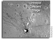
NASA’s Lunar Reconnaissance Orbiter (LRO) captured the sharpest images ever taken from space of the Apollo 12, 14 and 17 landing sites. Images show the twists and turns of the paths made when the astronauts explored the lunar surface. At the Apollo 17 site, the tracks laid down by the lunar rover are clearly visible, along with the last foot trails left on the moon. The images also show where the astronauts placed some of the scientific instruments that provided the first insight into the moon’s environment and interior.”
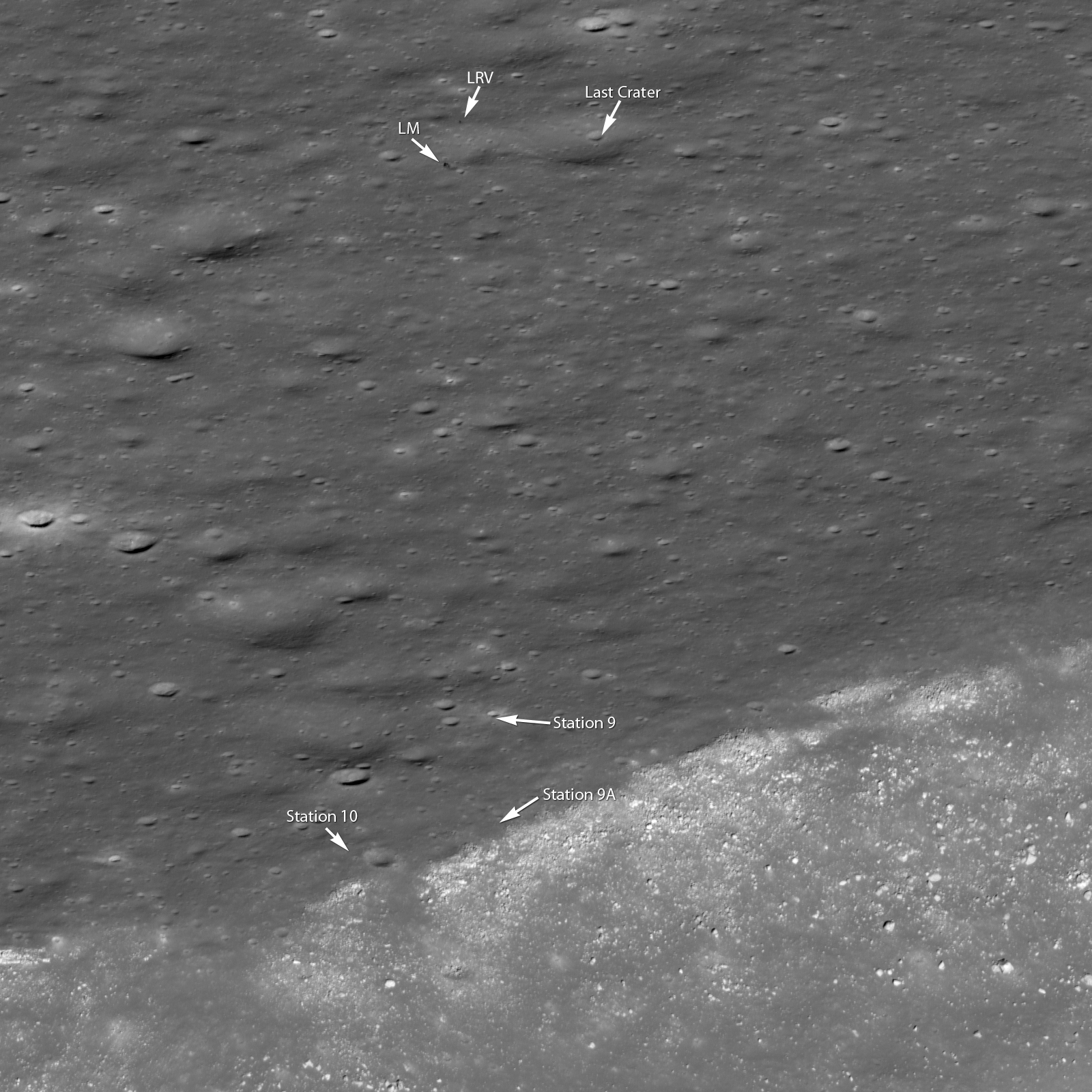
 More
Lunar Orbiter Image Recovery Project (LOIRP) Releases New Image of Apollo 12/Surveyor III Landing Site, earlier post
Lunar Orbiter Image Recovery Project (LOIRP) Releases New High Resolution Image of The Apollo 14 Landing Site With EVA Details, earlier post
Damaged Tape and Murky Moon Views (Apollo 11), earlier post
LOIRP Mentioned at Apollo 11 Anniversary Celebration, earlier post