Earliest Satellite Images of Antarctica

Long-lost images taken from the first Nimbus satellite are revealing new information about what the world looked like from space before the beginning of the modern-day satellite record in 1979. While NASA never really lost the data (it was stored in federal archives) they did lose the ability to access it for nearly 40 years. Recovered images of Antarctica showed a greater extent of sea ice than ever measured before by scientists–but the record was short lived. In an odd twist of fate, the new record was broken in September 2014, only weeks after the discovery.

Continue reading “Earliest Satellite Images of Antarctica”

Crowdsourcing a Century of Astronomical History


“The project, called Digital Access to a Sky Century at Harvard (DASCH for short), is actually a collaboration between the Harvard College Observatory and the Smithsonian Institution, the latter of which has embarked on a much larger endeavor to crowdsource the transcription of millions of pages of archival material. The DC-based network of museums launched a beta version of its crowdsourcing platform in June 2013, and over the next year about 1,000 volunteers transcribed 13,000 pages of documents. After emerging from beta in August and opening up to the public, that volunteer list has swelled to over 4,000. Though it isn’t the first archival institution to begin digitizing its collected works — everyone from the New York Public Library to the British Museum have launched similar initiatives — its scope of work is arguably the most massive; there are 137 million objects spread across the Smithsonian’s 19 museums.”
More at “Why Harvard and the Smithsonian teamed up to crowdsource a century of astronomical history

Please Help Preserve This Historic Astronomical Data

Volunteers Needed to Preserve Astronomical History and Promote Discovery
“Digitizing the ~500,000 glass plate images covering the full sky will foster new scientific discoveries for the currently ‘hot’ field of studying variability of astronomical objects, or time domain astronomy, as we bring to light these long-hidden archives,” says Harvard professor Josh Grindlay, the leader of the Digital Access to a Sky Century at Harvard (DASCH) project. The telescope logbooks record vital information associated with a 100-year-long effort to record images of the sky. By transcribing logbook text to put those historical observations in context, volunteers can help to unlock hidden discoveries.”

Technoarchaeology and Nimbus Weather Data

NIMBUS: Recovering the Past


Dumpster Diving for Science
“Last month, researchers working out of an abandoned McDonald’s restaurant on the grounds of NASA Ames Research Center recovered data collected by NASA’s Nimbus II satellite on 23 September 1966. The satellite soared over Earth in a polar orbit every 108 minutes, taking pictures of cloud cover and measuring heat radiated from the planet’s surface, and creating a photo mosaic of the globe 43 years ago. The resulting image is the oldest and most detailed from NASA’s Earth-observing satellites. It’s also the latest success story in what researchers call techno-archaeology: pulling data from archaic storage systems. Once forgotten and largely unreadable with modern equipment, old data tapes are providing researchers with new information on changes in the surfaces of Earth and the moon…”
Nimbus II and Lunar Orbiter 1 Imagery: A New Look at Earth in 1966
“The LOIRP required a lot of what has come to be called “techoarchaeology” that is, going back in time to the original data and recording devices, using modern enhancements. The expertise gained by the LOIRP team eventually caught the attention of the folks at the National Snow and Ice Data Center (NSIDC). Data from the Nimbus weather and earth observation satellite – in orbit at the same time as the Lunar Orbiters were circling the Moon – had languished for years in the national archives until John Moses NASA Goddard Space Flight Center had them digitized. Dr. Walt Meir of the National Snow and Ice Data Center, after seeing the work that the LOIRP team had done in potentially identifying the Antarctic sea ice in the Lunar Orbiter 1 Earthrise image, and recognizing the similarity between the raw data of the Nimbus and Lunar Orbiter data, provided a grant to the LOIRP team to process the Nimbus data into a modern format and to correct image artifacts that are common to both types of images. The LOIRP team accomplished this, and rendered the images into the Google Earth format using a variety of internally developed techniques and elements of the NASA Ames developed NASA World Wind Java software development kit.”
Techno-archaeology rescues climate data from early satellites, NSDIC
“Starting with the methods developed for the Lunar Orbiter Image Recovery Project (LOIRP) at NASA Ames Research Park, a team at NSIDC worked with Dennis Wingo at LOIRP to search NASA archives for the original Nimbus tapes containing raw images and calibrations. Their first goal was to read and reprocess the data at a higher resolution, removing errors resulting from the limits of the original processing.”
LOIRP Aids In Finding Google Earth Images from 1966
“After determining that it was highly unlikely that any of the early Nimbus 2″ analog tapes still existed we began our work to rectify some of the image artifacts in the Nimbus II HRIR data files. The data that we were working with is remarkably similar to the Lunar Orbiter raw analog data, but this is two generations removed from the raw data, the sync pulses and the calibration data had been removed. This was probably in order to save tape back in the 1960’s. The surviving original data today is of fairly poor quality.”
Technoarchaeology: Nimbus and LOIRP

International Cometary Explorer (ISEE-3) Beacon Signal Detected


“On March 1st and 2nd, 2014 radio amateurs were able to detect the beacon signal from the retired NASA deep space probe ICE (International Cometary Explorer) at the Bochum Observatory (Germany). After some changes to the ground equipment and aligning the receive antenna to the predicted position in the sky, the beacon signal could positively be identified due to its frequency, the position in the sky and the frequency shift due to the radial velocity (Doppler shift). For this detection the 20m radio telescope from the Bochum Observatory was used. In 2003, AMSAT-DL converted this former industrial monument into a fully functional groundstation for deep space probes. Since 2009 the facility is being used by volunteers almost full time as ground receive station for data from the STEREO mission with its two spaceprobes monitoring the sun from different viewing angles.”
– More at AMSAT-DL and Bochum Observatory receive signal from retired NASA spacecraft
NASA Could Try To Contact ISEE-3/ICE – But It Won’t, earlier post

Please Support The Astronomy Legacy Project


10 February 2014: We are excited to announce that the Astronomy Legacy Project was launched today! You can find it at http://www.indiegogo.com/projects/astronomy-legacy-project/. We are fully committed to digitizing 120 years of photographic films and plates, placing this treasure in your hands. Help bring the past 120 years of the night sky into the future! Contribute what you can: donations are welcome, posts are welcome, tweets are welcome, and your expertise and encouragement are welcome! You become a part of the Astronomy Legacy Project Team with your contribution – part of a legacy itself for generations to come. Follow us on Twitter @remarkablestars.
Astronomy Legacy Project

Technoarchaeology: Bringing Colossus Back Online

Historic Colossus computer marks 70th anniversary, Gizmag
“In 1994, Tony Sale, co-founder of the National Museum of Computing, started the effort to rebuild Colossus. Based on bits of information released by the government starting in the 1970s, eight photographs of the original machines, and surviving circuit diagrams kept by engineers, a team managed to reconstruct the computer, which went operational at the museum on November 15, 2007, and on March 6, 2012, became the centerpiece of the Colossus gallery, where it is a working exhibit.”

NASA Could Try To Contact ISEE-3/ICE – But It Won’t

From the ISEE-3 Returns Facebook page: Communication involves speaking, listening and understanding what we hear. One of the main technical challenges the ISEE-3/ICE project has faced is determining whether we can speak, listen, and understand the spacecraft and whether the spacecraft can do the same for us. Several months of digging through old technical documents has led a group of NASA engineers to believe they will indeed be able to understand the stream of data coming from the spacecraft.
NASA’s Deep Space Network (DSN) can listen to the spacecraft, a test in 2008 proved that it was possible to pick up the transmitter carrier signal, but can we speak to the spacecraft? Can we tell the spacecraft to turn back on its thrusters and science instruments after decades of silence and perform the intricate ballet needed to send it back to where it can again monitor the Sun? The answer to that question appears to be no.
The transmitters of the Deep Space Network, the hardware to send signals out to the fleet of NASA spacecraft in deep space, no longer includes the equipment needed to talk to ISEE-3. These old-fashioned transmitters were removed in 1999. Could new transmitters be built? Yes, but it would be at a price no one is willing to spend. And we need to use the DSN because no other network of antennas in the US has the sensitivity to detect and transmit signals to the spacecraft at such a distance.
This effort has always been risky with a low probability of success and a near-zero budget. It is thanks to a small and dedicated group of scientists and engineers that we were able to get as far as we have. Thank you all very much.

Magnetic Tape Drives Are Back In Style

Magnetic tape to the rescue, Economist
“The need for mass storage is reviving a technology which, only a few years ago, seemed destined for the scrapheap: magnetic tape. Tape is the oldest computer storage medium still in use. It was first put to work on a UNIVAC computer in 1951. But although tape sales have been falling since 2008 and dropped by 14% in 2012, according to the Santa Clara Consulting Group, tape’s decline has now gone into reverse: sales grew by 1% in the last quarter of 2012 and a 3% rise is expected this year. Alberto Pace, head of data and storage at CERN, says that tape has four advantages over hard disks for the long-term preservation of data. The first is speed. Although it takes about 40 seconds for an archive robot to select the right tape and put it in a reader, once it has loaded, extracting data from that tape is about four times as fast as reading from a hard disk.”

NASA Technoarchaeology at University of Alabama Huntsville

University of Alabama Huntsville: With billions of dollars of past space research at risk of being lost forever, Dr. Charles Lundquist is running a race against technology and time.
Director of the Interactive Projects Office at The University of Alabama in Huntsville’s Research Institute, the 85-year-old Dr. Lundquist spent 40 years in high-level positions with the U.S. Army, the Army Ballistic Missile Agency, NASA, and finally the University of Alabama in Huntsville. He officially retired in 1999. Working as a volunteer since then, he spends his time sleuthing for past research from the Army, NASA and private papers, as well as collecting oral histories from NASA retirees and others. All are added to an archive on the ground floor of UAH’s M. Louis Salmon Library, where Anne Coleman is a reference librarian and head of Archives and Special Collections. The archives preserve continued access for future historians, scholars and students.
Image: Dr. Charles Lundquist, director of Interactive Projects at the UAH Research Center, and Anne Coleman, reference librarian and head of Archives and Special Collections, with obsolete media containing data from the U.S. space program. The IBM printout that Dr. Lundquist is reading is the only surviving copy of the telemetry he needed for research from NASA’s Gravity Probe A mission. The original tape from the 1976 flight is no longer readable. Larger image

Continue reading “NASA Technoarchaeology at University of Alabama Huntsville”

Video: Oscilloscope Trace of Lunar Orbiter Image Playback


Dennis Wingo: This is a two minute video that shows, about every 42 seconds, a shift in the video. This occurs when the line is scanned to the end of a framelet, over the calibration features that were pre recorded in the tape. Keith has posted images here that show the relationship between the scope trace and the dynamic range of the tapes. This gives us a qualitative measure of the performance of the tape drive. Even in its sub optimized state today, the scope trace almost exactly matches the original transfer function of the spacecraft film, thus giving us a means to evaluate the quality of the analog data derived from the tape.

A Lunar Orbiter Image Last Seen 47 Years Ago


After being forgotten for nearly 47 years, three high resolution images taken by the Lunar Orbiter II spacecraft have been rediscovered by the Lunar Orbiter Image Recovery Project (LOIRP). It is unlikely that anyone has seen these images since they were sent back to Earth. Indeed, it is unlikely that very many people saw them at that time either.
The three high resolution images were taken along with a medium resolution image on 23 November 1966 at 17:05:39 GMT. The center point of the images was 26.94 West Longitude, 3.196 degrees North Latitude. The images were taken at an altitude of 43.6 km and the image resolution is 0.93 meters.
We recently came across these three images (#2159) and noticed that they do not appear online at the LPI Lunar Orbiter database. Only the medium resolution image gets mentioned at LPI.
These three images were retrieved from original Lunar Orbiter program analog data tapes yet they appear nowhere in NASA’s publications. They do appear on microfilm archives at LOIRP and are mentioned in a simple data log online at LPI. LOIRP has a more extensive computer printout of this data that shows more detail about the images – but not the images themselves.
Unless someone happened to be looking through this microfilm collection (LOIRP has the only extant copy) then it is pretty safe to assume that no one has actually seen these images since a technician saw them on a TV monitor in 1966.


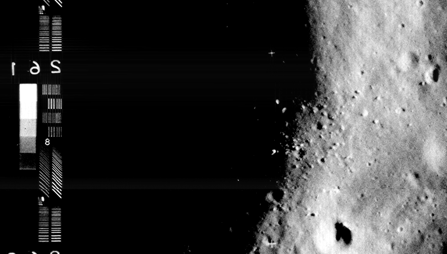
– Left Image [larger] [Raw TIFF – very large]
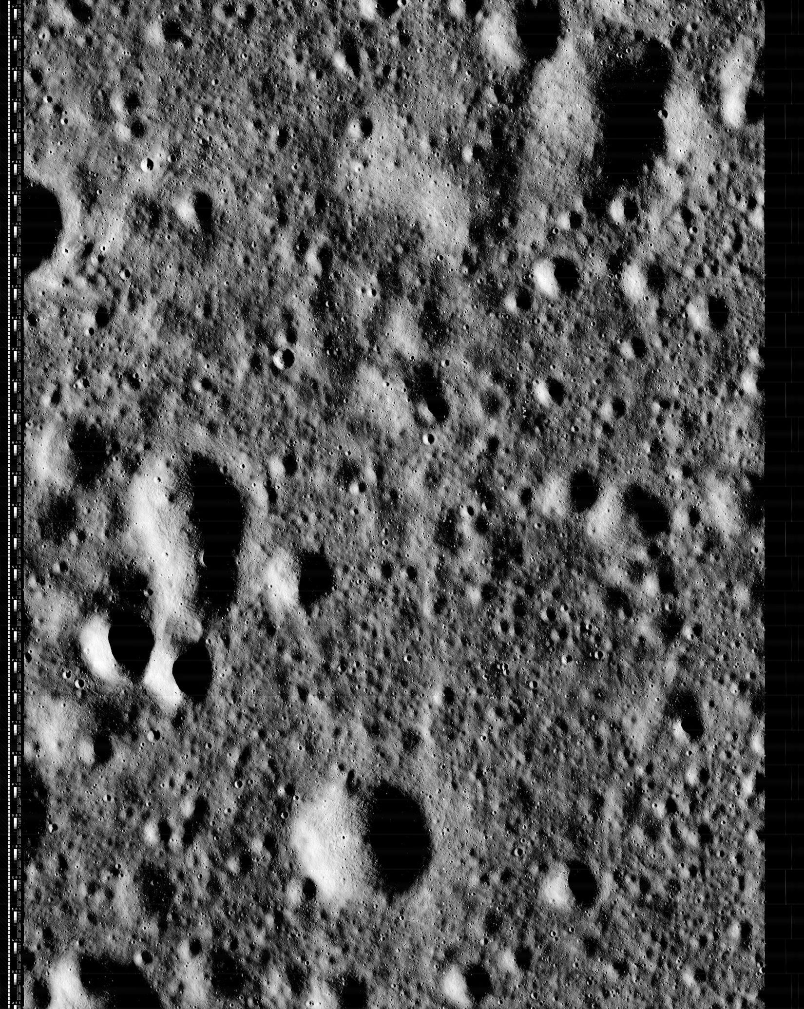
– Middle Image [larger] [Raw TIFF – very large]
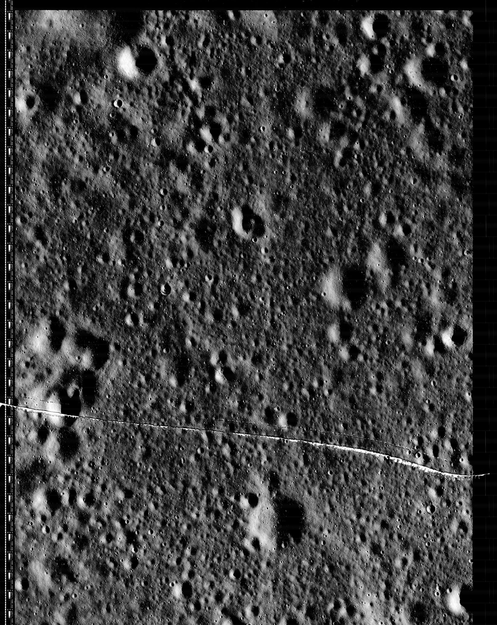
– Right Image [larger] [Raw TIFF – very large]
Note: These three images actually comprise portions of a single high resolution image but these high resolution images were traditionally divided up and numbered in three parts by the Lunar Orbiter program.
The Lunar Orbiter project was rather well documented. Indeed, it is this documentation that allowed the LOIRP to figure out what images are located on which tape, but also how to repair and replace hardware on our 50 year old tape drives. In the course of retrieving images from the original analog data tapes we have come across a number of images – some only partial images – that are not included in formal program documentation or listed in LPI or USGS databases.
We have a working theory as to why these images have been forgotten for the past 47 years. There were three ground stations involved in retrieving data from Lunar Orbiters – Woomera, Australia, Madrid, Spain, and Goldstone, California. There is some overlap due to planetary geometry such that images were often recorded by more than one ground station.
When the spacecraft was playing back its imagery there was only one chance to get the data since it was really not feasible (or advisable) to rewind the film and re-scan and retransmit – since there was no ability to store these images electronically on the spacecraft. So, if one or more ground stations did not record data the first time it was sent, there was no second chance.


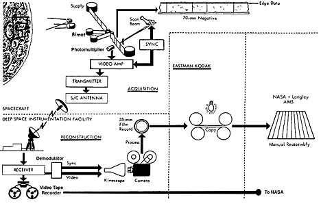
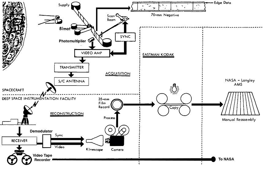
How data was sent back to Earth and stored as photographs and data tapes. Click on image to enlarge.
Lunar Orbiters shot their images on 70mm SO-243 photographic film. The film was developed aboard the spacecraft, scanned and sent back to Earth as analog data. One data stream demodulated the image and sent it to a high resolution kinescope (TV screen) where the image on the screen was photographed as a photographic positive. Those photographs were subsequently re-photographed to create a negative, then stitched together and photographed again to create photographic prints used for the requirements of the program.
The data was also sent to analog videotape machines where it was recorded for posterity. Given that the data stored on the analog tapes was scanned directly from the film in lunar orbit and recorded as data on magnetic tape these images were of much higher quality than the photos taken off of the kinescope and re-photographed multiple times. These data tapes were used sparingly to digitize small “chits” that were run through computer programs to measure the height of rocks on the surface and the slope of the surface within the landing ellipses chosen based upon looking at the photographic prints. These computer measurements were done to validate the safety of the landing area as this was difficult to do using just the film record.
The photographic process of capturing kinescope images continued as long as data was being received. But the data tapes had to be changed out after several images had been recorded. However, the spacecraft playback continued while the technicians changed out the tapes – and that process took a few minutes. During the time that the tape was being changed out analog data was not being recorded by that ground station – but it might be recorded by another during the overlap period. Then again it might not.
The way that the images came down involved the transmission of a medium resolution version of an area followed by high resolution images of that area. So, tape changeout tended to happen as the medium resolution image came in. That way, at most, a small portion of the medium resolution image was not recorded on tape. But the photographs of the images appearing on the kinescope continued nonstop – hence the presence of these images on our microfilm collection (these microfilm images were originally given to Dennis Wingo from then fellow student Eric Dahlstrom in 1989 after being purchased at surplus from NASA GSFC). The high resolution images were what most interested the Lunar Orbiter project team – the medium resolution images served to place the high resolution images into context.
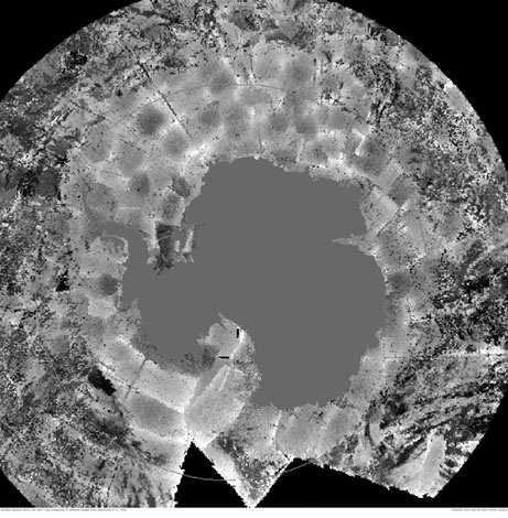
Detailed information on image 2159. Click on image to enlarge.
You might wonder why each ground station did not have more than one tape drive. Well, given the expense of these drives, they were lucky just to have one at all three ground stations. Most of the time the images were captured without incident, often by more than one ground station.
Sometimes flaws in the film or glitches on the playback system on the spacecraft would cause flawed images to be sent back. Those flawed images were usually of partial use. That said these flawed images were cataloged as part of the detailed program documentation. As good as these folks were with documenting things, some stuff fell through the cracks.
In the case of image 2159 we think that there was some problem with retrieving the image and that it was designated as having a flaw – but that fact never made it into program documentation. The images were on microfilm that were derived from the data tapes. But the high resolution imagery for 2159 was not printed out and assembled into prints for use by the project team. When we retrieved this high resolution image we did encounter some problems that necessitated some hand assembly. This could well have been part of the problem experienced in 1966.
Regardless of the cause(s) we have retrieved the his resolution imagery and have made it public. Over the next few weeks we’ll be releasing some other images which may have suffered a similar fate.
The Lunar Orbiter Image Recovery Project (LOIRP) is located at the NASA Ames Research Center in Moffett Field, CA. Funding and support for this project has been provided by NASA Headquarters, NASA Lunar Science Institute, NASA Ames Research Center, SkyCorp Inc., and SpaceRef Interactive Inc.
For more information on the Lunar Orbiter Image Recovery Project (LOIRP) visit https://moonviews.wpenginepowered.com
For information on NASA’s Lunar Science Institute visit http://lunarscience.arc.nasa.gov/