
 LROC’s best look yet at the Apollo 11 Landing site. The remnants of Armstrong and Aldrin’s historic first steps on the surface are seen as dark paths around the Lunar Module (LM), Lunar Ranging RetroReflector (LRRR) and Passive Seismic Experiment Package (PSEP), as well as leading to and from Little West crater. LROC M175124932R [NASA/GSFC/Arizona State University].
This image of the Apollo 11 landing site captured from just 24 km (15 miles) above the surface provides LRO’s best look yet at humanity’s first venture to another world. When Neil Armstrong took his famous first steps onto the lunar surface, he kicked around the soil. “Yes, the surface is fine and powdery.” Gazing at the flat horizon, he took in the view. “Isn’t that something! Magnificent sight out here.” After collecting a contingency sample Neil looked around and observed, “it has a stark beauty all its own. It’s like much of the high desert of the United States. It’s different, but it’s very pretty out here.” A few minutes later Buzz Aldrin descended the ladder and joined Neil on the surface of the Moon!
You can see the remnants of their first steps as dark regions around the Lunar Module (LM) and in dark tracks that lead to the scientific experiments the astronauts set up on the surface. The Passive Seismic Experiment Package (PSEP) provided the first lunar seismic data, returning data for three weeks after the astronauts left, and the Laser Ranging RetroReflector (LRRR) allows precise measurements to be collected to this day. You can even spot the discarded cover of the LRRR.
Another trail leads toward Little West crater around 50 meters (164 feet) to the east of the LM. This was an unplanned excursion near the end of the two and a half hours spent on the surface. Armstrong ran over to get a look inside the crater, and this was the farthest either astronaut ventured from the landing site. Compared to Apollo 12 and 14, which allowed for more time on the surface, and Apollo 15, 16, and 17, which had the benefit of a Lunar Roving Vehicle, Armstrong and Aldrin’s surface activities were quite restricted. Their tracks cover less area than a typical city block!
More
New LRO Image of Apollo 15 Landing Site
 The Apollo 15 Lunar Module (LM) Falcon set down on the Hadley plains (26.132*N, 3.634*E) a mere 2 kilometers from Hadley Rille. The goals: sample the basalts that compose the mare deposit, explore a lunar rille for the first time, and search for ancient crustal rocks. Additionally, Dave Scott and Jim Irwin deployed the third Apollo Lunar Surface Experiments Package (ALSEP) and unveiled the first Lunar Roving Vehicle (LRV). The ALSEP consisted of several experiments that were powered by a Radioisotope Thermoelectric Generator (RTG) and sent back valuable scientific data to the Earth for over six years after the astronauts left. This new LROC NAC image taken from low altitude shows the hardware and tracks in even more detail.
The LRV, a lunar “dune buggy”, allowed the astronauts to traverse far from the LM and explore much more local geology than the astronauts on previous missions (Apollo 11, 12, 14). Not only did the LRV allow the astronauts to move from place-to-place at a lively rate of eight to sixteen kilometers per hour (five to ten miles per hour), but the LRV also allowed brief periods of rest that in turn helped to conserve oxygen.
The LRV wheels were 82 centimeters (32 inches) in diameter, and 23 centimeters (9 inches) wide. Typically LROC NAC pixels are about 50 centimeters square, so it is not always easy to pick out the LRV tracks. In previous LROC images, the LRV tracks are usually only visible near the LM where the descent engine exhaust plume disturbed the surface. The LRV wheels broke through the changed surface and thus the tracks have more contrast near the LM.
For two one-month periods last year (2011), the LRO orbit was lowered such that overflights of the Apollo sites were only 25 to 30 kilometers, rather than the usual 50 kilometers. These low passes resulted in NAC pixel scales near 25 centimeters! LRO has a ground speed of a bit over 1600 meters (5249 feet) per second, and the shortest NAC exposure time is 0.34 millseconds, so images taken from this low altitude are smeared down track a bit. However, the smear is hardly noticeable and features at the Apollo sites definitely come into sharper focus. In this new low-altitude NAC image of the LRV, tracks are visible about half of the time, usually when the tracks are at an angle to the Sun direction, rather than parallel.
More
New Use For An Apollo-era Satellite Station?
 A Real Estate Deal That Spans The Earth, NPR
“As it turns out, the greatest interest in the property has been because of that satellite dish. NASA contractor Dennis Wingo is seriously looking at it. He’s advising a team competing for the Google Lunar X Prize, a $20 million award for the first privately funded team to get a rover to travel on the moon. “We would control them from here,” Wingo says. “To me, that’s way more fun than worrying about the past. As important as the past is, I kind of look forward toward the future.” At this point, Wingo hasn’t made an offer, so the property is still on the market. The asking price for the dish, the bunker and the land: $4.2 million.”
Lunar Orbiter Image Recovery Project Featured in MountainView Voice
 One giant leap for former fast-food joint, MountainView Voice
“Inside a shuttered McDonald’s at NASA Ames Research Center is a surreal scene: stacks of silver disc-shaped film canisters, an old reel-to-reel tape machine and the sound of NASA technicians talking during a 1960s mission to photograph the moon. What is going on is a sort of archeology of the digital age, or “techno-archeology” as it is called by Dennis Wingo, the man in charge of the Lunar Orbiter Image Recovery project. Wingo, CEO of Skycorp Inc., is the space industry entrepreneur who partnered with NASAWatch.com editor Keith Cowing to promote the project in 2008.”
China Releases High Resolution Moon Maps Made From Chang’e-2 Data

China on Monday published a set of full coverage of moon map and moon images with a resolution of seven meters captured by the country’s second moon orbiter, the Chang’e-2. (Xinhua Photo)
BEIJING, Feb. 6 (Xinhua) — China on Monday published a full coverage map of the moon, as well as several high-resolution images of the celestial body, captured by the country’s second moon orbiter, the Chang’e-2.
The map and images, released by the State Administration of Science, Technology and Industry for National Defence (SASTIND), are the highest-resolution photos of the entirety of the moon’s surface to be published thus far, said Liu Dongkui, deputy chief commander of China’s lunar probe project.
The images were photographed by a charge-coupled device (CCD) stereo camera on the Chang’e-2 from heights of 100 km and 15 km over the lunar surface between October 2010 and May 2011, according to a statement from SASTIND.
The resolution of the images obtained from Chang’e-2 is 17 times greater than those taken by the its predecessor, the Chang’e-1.
Continue reading “China Releases High Resolution Moon Maps Made From Chang’e-2 Data”
Where is McMoon’s?
McMoons is located here at NASA Ames Research Park at Moffett Field, CA. Next to our building (Building 596) is a 50 year old Titan 1 ICBM that we’re helping students to restore, upgrade, and transform into a teaching tool. We like to make old stuff work.
Click on images to enlarge

More images below
Technoarchaeology: Learning New Things from Old Technology
 Technologies that we’ve lost – and the quest to find them again, io9
“I asked NASA Watch’s Keith Cowing about this, and he explained that this is just an urban legend. The schematics are all still around, mostly on microfiche, and any ancient computer files just hold images of the original plans as opposed to now unreadably obsolete data. Still, while the knowledge wasn’t lost, it was certainly forgotten, and worse, it was badly organized. As Cowing – himself working on the rediscovery of old NASA documents with the Lunar Orbiter Image Recovery Project – told me, all this archival information was basically abandoned until NASA’s started working on the Constellation program last decade, and now that that project has been forgotten the information is again beginning to gather dust. If there is a point of disconnect, it’s more in terms of how we understand the information and the different ways in which we approach science forty-five years on:”
“If anything’s missing, it’s actually more the explanation. I mean there is some stuff that will never be found again, but it’s all there, and the stuff that isn’t you can sort of figure out backwards. Sometimes you need the equivalent of a Rosetta Stone, because sometimes the way we think today is not the way they thought back then. Sometimes you need an index or a document that explains how they did things or their nomenclature. That’s the one thing that’s sometimes hard to find is what I call a bridge document, an answer guide to how they did the thing back in the sixties. There’s no FAQ.”
What It Is Like To See Images From The Past

Keith’s note: This pic from the film “Contact” is what it was like when we got our first image – “Earthrise” – in 2008. I was watching over the team’s shoulders via iChat from the east coast and the image appeared – in reverse B&W – we saw the ‘white’ of space and the ‘black’ of the Moon. And then we flipped it. Awesome – like using a time machine to grab something from the past. Just like “Contact”.
Below is the scene from “Contact” where a 1936 TV broadcast – sent back to Earth by an alien intelligence as a way to say “message received” – is slowly decoded.
Lunar Orbiter Image Recovery Has Started Up Again at McMoons

The team at McMoons (Bldg 596 at NASA Ames Research Park) got the prime FR-900 tape drive up and running today at full capacity and has already downloaded new images. We have some new tricks up our sleeves – and we’ll soon be showing you the best pics yet – plus some familiar ones clearer than before.
Video of Lunar Orbiter imagery retrieved today

Technoarchaeology: Restored Gemini Program Photos

Source, Gemini VII.
Restored Photos: Project Gemini Comes to Life
“On 23 March 1965, the first of ten crewed Gemini spacecraft was launched carrying it’s crew of two astronauts, Gus Grissom and John Young. The NASA Johnson Space Center and the School of Earth and Space Exploration at Arizona State University today proudly unveil the Project Gemini Online Digital Archive. The archive contains the first high-resolution digital scans of the original Gemini flight films, now available in several formats with a click of your mouse.”
Buzz Aldrin Visits Lunar Orbiter Image Recovery Project
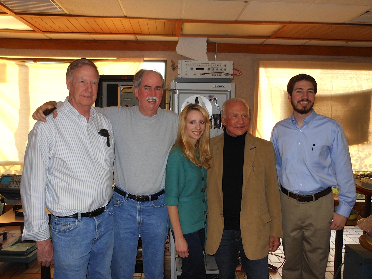
On 6 January 2012, Apollo 11 astronaut Buzz Aldrin visited the Lunar Orbiter Image Recovery Project (LOIRP) located at Building 596 aka “McMoons” at the NASA Ames Research Park at Moffett Field, CA. Pictured (L to R): LOIRP Engineer Ken Zin, LOIRP Co-Lead Dennis Wingo, LOIRP Student Intern Neulyn Moss, Buzz Aldrin, LOIRP Image Specialist Austin Epps. Behind them is the FR-900 Tape drive restored and enhanced by LOIRP to play back the original analog data tapes generated by the five Lunar Orbiter missions in the 1960s. Larger image

Buzz Aldrin takes a moment to autograph our FR-900 tape drive. Larger image