
“Before this century, the last transit of Venus was in the year 1882. What a different world it must have been! We can’t imagine what it was like to have been there, but – thanks to this video from Tony Misch and William Sheehan – we can almost glimpse the 1882 Venus transit through the eyes of 19th century astronomers.” More at EarthSky
Iconic Lunar Orbiter Image of Copernicus Re-released

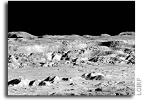
Today an iconic image from the initial exploration of the Moon is being re-released showing detail that could not have been seen using technology available at the time the photo was taken. This image features a dramatic view inside the majestic crater Copernicus – a view that left millions in awe when it was first released.
This image was announced at the First Global Space Exploration Conference, co-sponsored by the AIAA and IAF, in Washington, DC.
Between 1966 and 1967 NASA sent five Lunar Orbiter spacecraft to the Moon. Their job was to survey the surface to help determine landing sites for the upcoming Apollo missions. In addition to their recon role, these spacecraft also contributed to the nascent scientific understanding of the Moon. But every once in a while these spacecraft also served as artists, snapping photos of this nearby world in a way that human eyes had never been able to see before.
Once such image was taken of crater Copernicus on 24 November 1966 by the Lunar Orbiter 2 spacecraft. What made this photo so unique was the oblique angle it was taken at as well the close proximity of the spacecraft to its target. The image was taken at an altitude of 45 km (27.1 miles) at a distance of approximately 207.7 km (~125 miles) from the center of the crater. Instead of looking down, the spacecraft looked sideways at the Moon.
For the first time people saw the Moon as a world with mountains and boulders and other features (some of them strange) that were not apparent from photos where the view was looking straight down. So taken were people at the time that Life Magazine took to calling the photo “The Picture of the Century”. Along with the equally famous Earthrise image taken by Lunar Orbiter 1, the Moon went from being a distant sight in the sky to a world waiting to be explored – in person.
At the time that the images were taken using film that was actually developed aboard the spacecraft in lunar orbit, the ability to send back imagery was nothing like it is today. The photos were scanned much like news photos of the day and the data was sent back to Earth. The images were then printed out on photo graphic paper and used to construct maps of the lunar surface. In so doing a lot of data from the original photos was lost. Luckily NASA had the foresight to listen to the suggestions of project engineers such as Charles Byrne and stored the original data on analog tapes.
Some 40 years after these missions were completed the Lunar Orbiter Image Recovery Project (LOIRP) was begun with the intent of using refurbished tape drives and a complete set of original project tapes (over 1,500). Utilizing funding from NASA, facilities offered by NASA Ames Research Center, and donated effort and resources from SkyCorp Inc. and SpaceRef Interactive Inc., the LOIRP team was able to return the original drives to operation such that the data on the tapes could be accessed.
By adding modern computer interfaces and data handling techniques, the LOIRP was able to scan and record the data in ways that simply could not have been accomplished in the 1960s. As a result the images that were obtained had a much higher resolution and dynamic range than had been seen to date. Indeed, in many cases, these images often rival or exceed images taken by the Lunar Reconnaissance Orbiter which is currently surveying the Moon.
In 2009 LOIRP released its first attempt to retrieve this image of Copernicus. In the ensuing several years the process of calibrating thee tape drives, scanning the tapes, and assembling and processing the imagery has improved to the point that a new attempt to retrieve the image was undertaken.
This project is multi-generational in many ways. The tape drives use original parts and modern components and are connected to monitoring equipment that is itself decades old. All of this is connected to Mac desktop computers running of the shelf software. There are some special tools. Some of the software LOIRP now uses to process these images was written by Charles Byrne – the very same person who suggested that these images be stored on data tapes over 40 years ago.
LOIRP also involves the participation of young people such as Austin Epps and Neulyn Moss in the process of generating and analyzing the images. LOIRP also has a regular series of local students working as interns to assist the project.
It is important to remember that as we look toward the Moon, Mars and other places as future destinations that we are not the first generation to do so. In the 1960s people had the same dreams – and they acted upon them with simpler tools than we have today. There is a lot to be gained from talking to people from that era. They have more than just memories of these days. Unlike many of us today, they know how to actually make their dreams become reality. That advice is timeless and is something that needs to be passed on to a new generation. We take it very seriously at LOIRP. Indeed, had we not done so, we’d never have retrieved these images.
About LOIRP
The Lunar Orbiter Image Recovery Project (LOIRP) is located at the NASA Research Park at Moffett Field, CA. Funding and support for this project has been provided by the NASA Human Exploration Operations Mission Directorate, the NASA Innovative Partnerships Program, the NASA Lunar Science Institute, NASA Ames Research Center, SkyCorp Inc., and SpaceRef Interactive Inc.
For more information on the Lunar Orbiter Image Recovery Project (LOIRP) visit https://moonviews.wpenginepowered.com
For information on NASA’s Lunar Science Institute visit http://lunarscience.arc.nasa.gov/
IMAGES

Image: This is the newly reprocessed view of Copernicus. (larger image) (Raw image 683.2MB LINK NOT WORKING) Credit: LOIRP
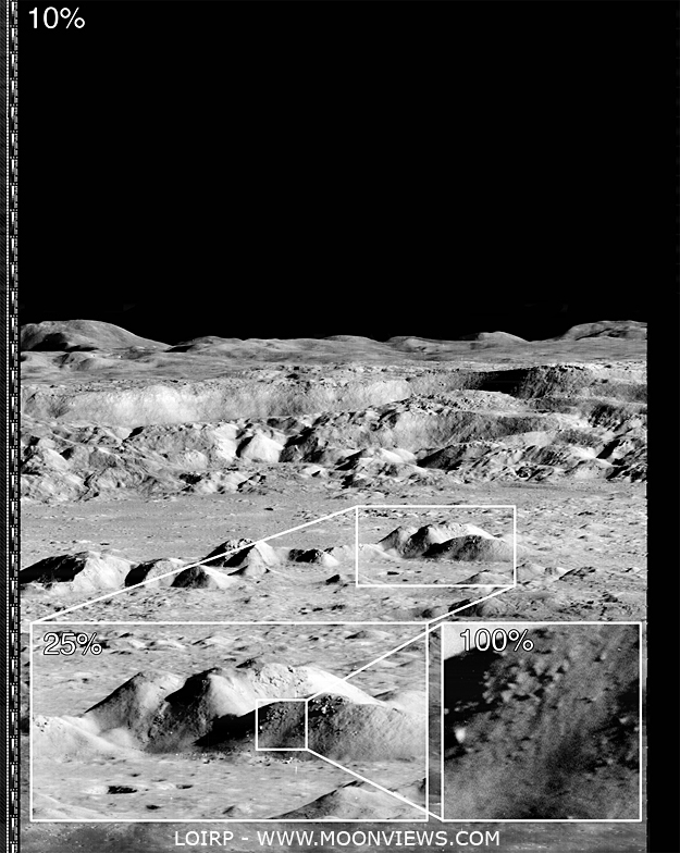
Image: This image shows the magification that is possible with the LOIRP image recovery process (larger image) Credit: LOIRP

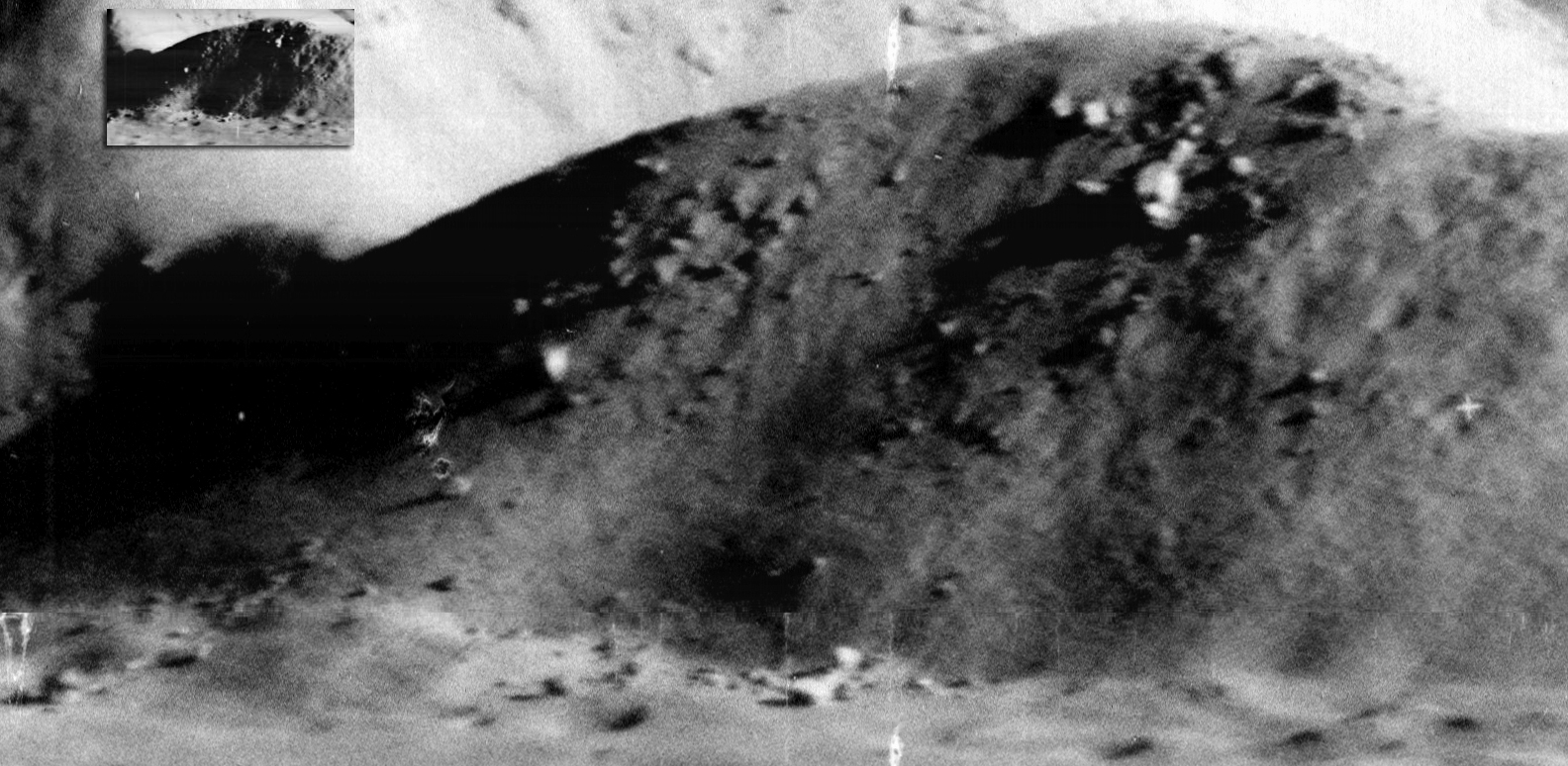
Image: If you take the highest resolution image that is available on the LPI Lunar Orbiter site and compare it with the new LOIRP image, the increase in size becomes obvious. Credit: LOIRP

Image: The amount of detail that the new image reveals is clear. Not only is the resolution much higher, but the dynamic range is greater so as to allow gradations in surface texture, shadows, etc. to be much more clearly pronounced (larger image). Credit: LOIRP
Preserving History on the Moon
 NASA Offers Guidelines To Protect Historic Sites On The Moon
“NASA and the X Prize Foundation of Playa Vista, Calif., announced Thursday the Google Lunar X Prize is recognizing guidelines established by NASA to protect lunar historic sites and preserve ongoing and future science on the moon. The foundation will take the guidelines into account as it judges mobility plans submitted by 26 teams vying to be the first privately-funded entity to visit the moon.”
Photos of the Ampex FR-900 and AR-550 Tape Drive Design Team

The Ampex FR-900 and AR-550 design teams. The FR-900 tape drives are the large units in the background and were used to record images sent back by the Lunar Orbiter missions. We have two refurbished FR-900s at the LOIRP at McMoons at NASA Ames Research Center. The smaller tape drive in front, the AR-550 is the flight version of the FR-900 and was flown aboard Skylab.

The Ampex AR-550 design team.
LRO Re-creates Apollo 8 Earthrise
 NASA’s Lunar Reconnaissance Orbiter Brings ‘Earthrise’ to Everyone
“To recreate this scene, NASA animator Ernie Wright reconstructed the orbit in software, using coordinates from an Apollo 8 mission report and photographs taken by the crew. “Apollo 8 was at 11 degrees south latitude and between 118 and 114 east longitude, with a westward view,” says Wright. “The floor of Pasteur crater is visible in the foreground of the photograph.”
 First Earthrise Photo Taken 45 Years Ago Today, Lunar Orbiter Image Recovery Project
“In 2008, this earthrise image was restored by the Lunar Orbiter Image Recovery Project at NASA Ames Research Center. We obtained the original data tapes from the mission (the last surviving set) and restored original FR-900 tape drives to operational condition using both 60s era parts and modern electronics.”
Apollo 9 Astronaut Rusty Schweickart Visits LOIRP

Apollo 9 astronaut and Lunar Module Pilot Rusty Schweickart paid a visit to the Lunar Orbiter Image Recovery (LOIRP) facility in Building 596 (aka “McMoon’s) at NASA Ames Research Park today. Pictured (L to R) Keith Cowing, LOIRP-co-lead, Rusty Schweikart, Austin Epps LOIRP, Neulyn Moss LOIRP, and Dennis Wingo, LOIRP co-lead.
Schweickart also signed our FR-900 tape drive as have other distinguished visitors before have done (image below)
Continue reading “Apollo 9 Astronaut Rusty Schweickart Visits LOIRP”
Lunakhod One Is Still In Its Parking Location
“Luna 17, carrying Lunokhod 1, landed on the flood basalt surface of Mare Imbrium on 17 November 1970, after entering orbit on 15 November. Today’s Featured Image of Luna 17 and Lunokhod 1 was obtained during a low altitude (33 km) pass providing the highest resolution view yet of the landing site.”
NASA LRO Image: Luna 24 Sitting On The Lunar Surface
 Luna 24 landed on the northwestern rim of a 64 m diameter impact crater, on the volcanic plains of Mare Crisium. Enlargement of lander at lower left, NAC M174868307L [NASA/GSFC/Arizona State University].
Three Soviet missions (Luna 16, Luna 20, and Luna 24) successfully collected and returned pieces of the lunar surface. Before the successful Luna 24 sample return mission in August 1976, Luna 23 was sent two years earlier (November 1974) to nearly the same location in Mare Crisium, but was unsuccessful.
Luna 24 landed in Mare Crisium on 18 August 1976 to complete the unfinished mission of Luna 23. The landing sites of Luna 23 and 24 are only 2.3 km apart. The region of Mare Crisium where they landed is a typical smooth mare surface with little relief in the immediate vicinity. There are numerous secondary craters scattered across the region, and Luna 24 landed on the edge of one of these. The secondary craters are the result of an impact to the northeast of the landing site, perhaps from the crater Giordano Bruno.
More information and imagery.
LOIRP Team Presents Poster at LPSC
 Integrating LRO Data Products for Preliminary North Pole Rover Mission Planning
“The authors believe that the selection of future sites for unmanned exploration of the Lunar surface should be driven by several short and long term objectives to maximize not only the scientific value of the selected site, but also the applicability of ground- truth data obtained from the surface to the longer term goal of Lunar resource utilization. Sites selected for unmanned surface science missions, such as the one being proposed in this document, will be a natural location of future outposts both unmanned and manned. Those outposts, in turn, become the natural beginnings for the economic development of the Moon’s resources.”
Download poster
Earthrise by MoonKAM
 Image: GRAIL’s MoonKAM Looks Homeward Toward Earth
“This image of the far side of the lunar surface, with Earth in the background, was taken by the MoonKAM system onboard the Ebb spacecraft as part of the first image set taken from lunar orbit from March 15 – 18, 2012. A little more than half-way up and on the left side of the image is the crater De Forest. Due to its proximity to the southern pole, DeForest receives sunlight at an oblique angle when it is on the illuminated half of the Moon.”
NASA LRO Image: Luna 23’s Rough Landing On The Moon
 Unfortunately, Luna 23 experienced a malfunction and hit the surface at a very high velocity. Contact was maintained between Earth and the spacecraft after landing, but a sample could not be acquired. At the time, the cause of the failure was not known, but it seemed probable that the whole spacecraft tipped over upon landing at an unexpectedly high velocity. Indeed, the high resolution LROC NAC image (below) shows the spacecraft lying on its side!
More information and imagery.
NASA LRO Image: Sharper View of Apollo 12 Landing Site
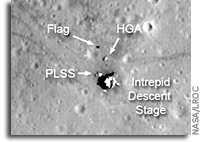 The Apollo 12 landing site in Oceanus Procellarum imaged during the second LRO low-altitude campaign. Image width is 225 m, NAC Image M175428601R [NASA/GSFC/Arizona State University].
The LRO mission continues to collect observations that are enabling ground-breaking new scientific discoveries about the Moon. As geologists, whenever we look at remotely sensed data collected from another planet, in a sense we are staring back in time. But this is the “deep time” of geology, where we are trying to understand natural processes that (at least on the Moon, anyway) could have happened billions of years ago. But the LRO mission is unique because we can also see human history. Not just any history, either, but one of humanity’s greatest accomplishments, our first steps on another world. Twelve astronauts explored the lunar surface, directly seeing things with their own eyes, making observations, and collecting samples with their own hands. These samples and observations revolutionized our understanding of our solar system.
This “snapshot in time” effect is especially evident at the Apollo 12 landing site in Oceanus Procellarum, now known as Statio Cognitum. Here, you can see the remnants of not one, but two missions to the Moon. Astronauts Pete Conrad and Alan Bean demonstrated that a precision lunar landing with the Apollo system was possible, enabling all of the targeted landings that followed. Bean and Conrad collected rock samples and made field observations, which resulted in key discoveries about lunar geology. They also collected and returned components from the nearby US Surveyor 3 spacecraft, which landed at this site almost two and half years previously, providing important information to engineers about the how materials survive in the lunar environment.
More