
On Monday evening a lavish reception was held at the National Air and Space Museum in Washington, DC on the occasion of the 40th anniversary of the Apollo 11 mission. The emcee for the event was Neil deGrasse Tyson. At one point, Tyson talked about the recent LRO images taken of the Apollo landing sites – and the hardware left behind. Our Apollo 11 landing site image was used to set the context for the LRO picture. Mention was also made of the LOIRP – Lunar Orbiter Image Recovery Project. Here is a video shot with a small camera of Tyson’s comments regarding our image.
Damaged Tape and Murky Moon Views

Image: Our retrieved image with the location of Apollo 11’s Eagle Descent Stage.
With the 40th anniversary of Apollo 11’s landing on the Moon upon us, everything old is new – or so it would seem. Yesterday we saw digitally re-mastered footage released showing the first steps on the Moon in unprecedented clarity. Also this was made from a copy that itself was a copy. The original video, recorded live as the Moon walks were underway has slipped into history – either misfiled or, more likely, erased and reused years later – much like a floppy disk. That said, the new footage does provide a window into the past with detail heretofore unseen.
Another place where windows are being opened into the past is the Lunar Orbiter Image Recovery Project (LOIRP) housed at NASA Ames Research Center. Utilizing ancient FR-900 tape drives, thousands of pounds of long forgotten image tapes, lots of loaned help including retired engineers and scientists, some money (from NASA ESMD, ARC, IPP, and NLSI, SkyCorp, and SpaceRef Interactive, and Odyssey Moon) and an old abandoned McDonalds restaurant (it was available – we call it “McMoons”), we’ve been able to bring these images back to life at resolutions greater than ever seen before. In many cases, until Lunar Reconnaissance Orbiter (LRO) takes new images, thee tapes represent the highest resolution images of the Moon ever taken from orbit.
As we ponder the sad news that the original Apollo 11 video has been lost, it is important to note that our Lunar Orbiter tapes might otherwise have been destroyed several years ago had not a stop order been placed on their destruction due to NASA’s search for Apollo 11 tapes and data. One project’s sad news is another’s execution reprieve.
Among our successes has been bringing the iconic Earthrise and Copernicus back to life in unprecedented detail. This time we need to report a major disappointment.
We recently released two Apollo landing site images – Apollo 12 and Apollo 14 and had embarked upon getting an nice crisp image of the Apollo 11 landing site in time for the anniversary.
Alas, unlike the unprecedented resolution we obtained for these two sites, Apollo 11 was a let down. The image is murky and far less clear than previous images. This is not due to the Lunar Orbiter spacecraft or our restored hardware. Rather, we expect, it had to do with someone playing this tape years ago and getting it jammed for an instant. Alas, the interesting part of this tape is framelet 411 which shows the Apollo 11 landing site. So, if there was a natural place on this tape to be paused, rewound, and played again and again and again, it is this location. Little surprise that the chance for damage to this portion of the tape occurred.
Our collection of tapes covers the entire five mission Lunar Orbiter project. While we are getting better at deciphering the nomenclature and labeling on the tapes, we still have much to learn. We can now find a specific tape and image in a straight forward process but have still only scratched the surface. And, paradoxically, we seem to have more tapes marked “Lunar Orbiter V” than we need to contain all of the images from that mission. We suspect that we have two (or more) archival collections mixed in or (for some reason) multiple copies of the same images. The only way to know for sure is to look at every tape – one by one.
The path to getting this Apollo 11 landing site image was complicated. The image was taken by Lunar Orbiter V on 12 August 1967 at 22:21:13.809 GMT at an altitude of 98. km. Properly retrieved, the resolution of our image should be 2.387 meters per pixel.
After our first round of image retrievals, the heads for our FR-900 tape drive needed to be refurbished. This is an expensive and time consuming process with only one or two places in the world capable of doing it. With the heads refurbished we were prepared to run the tape. As we did we found out that our custom made frame grabber had a bad chip which needed to be replaced.
Once the gear was good to go, the process of running the tape began. There was an ominous note on the tape can that a section of the tape might be damaged. We soon discovered that indeed there was some damage to a 4 minute segment and it was the portion we were most interested in.
Undaunted, Ken Zin, our experienced video tape drive engineer, Al Sturm our electronics guru, and Austin Epps, our vigilant student intern worked long hours to get everything working to see what sort of image we could get. Austin ran the tape multiple times os as to get multiple images we could use to produce a super resolution image of the landing site.
Despite this attempt to coax a little clarity out of the noise, the damage to the tape precluded an image of the quality we had hope for – and had achieved for other images. That disappointment aside, we feel that it is important to show our failures and disappointments as well as our crowning achievements. As you will see when you compare it to the best Lunar Orbiter images, the resolution is low. Yet if you compare it with the new LRO images you can clearly see that something appeared in the image and that the regolith was disturbed around that object (humans).
We will be combing through the Lunar Orbiter tapes this weekend with the hope that there is another (hopefully undamaged) version of this image.
We feel that it is equally important to reveal our failures and disappointments as it is to crow about our successes. We expect to have many of both.
Such is the curse of Apollo 11 – for an event so epic in its nature, the frail means where by we captured it and the planning that led up to it – are fleeting. One more reason why all of this fragile history needs to be maintained with constant vigilance – else we lose all of this to the dust of time.
For more information on the Lunar Orbiter Image Recovery Project (LOIRP) visit https://moonviews.wpenginepowered.com
For information on NASA’s Lunar Science Institute visit http://lunarscience.arc.nasa.gov/

Figure 1 Our retrieved image with the location of Apollo 11’s Eagle Descent Stage.

Figure 2 Comparing our retrieved image and that scanned by the USGS

Figure 3 Comparing our retrieved image, one scanned by the USGS, and LRO’s recent image.
Apollo 11: Before and After
 Moon Orbiter to Photograph Apollo 11 Landing Site, Space.com
“Taking the something old, something new approach is the Lunar Orbiter Image Recovery Project, located at the Ames Research Center in the heart of California’s Silicon Valley. This team effort is led by Dennis Wingo of SkyCorp, Inc. in Huntsville, Alabama and Keith Cowing of SpaceRef Interactive, Inc. of Reston, Virginia.
The recovery project involves culling through some 1,700 images taken by NASA Lunar Orbiter missions from the 1960’s, convert that data into digital form and then reconstruct the images to yield 21st century pictures far superior than the originals.
Ideally, upgrading an old Lunar Orbiter image taken of the Apollo 11 landing zone before Armstrong and Aldrin set foot there, contrasted to a new LRO overhead shot, would present a unique before/after look-see of the historic Tranquility Base site, said Greg Schmidt, deputy director of the NASA Ames-based Lunar Science Institute.
The Apollo sites themselves are extremely well characterized thanks to human explorers dispatched to those individual locales, Schmidt noted. LRO images of these areas will let us see the landers — and likely other artifacts such as the lunar buggies used in the Apollo 15, 16, and 17 missions – all of which will no doubt be very powerful in ways beyond mere science, he said.”
Remastered Apollo 11 Tapes
 NASA Holds Briefing to Release Restored Apollo 11 Moonwalk Video
“NASA will hold a media briefing at 11 a.m. EDT on Thursday, July 16, at the Newseum in Washington to release greatly improved video imagery from the July 1969 live broadcast of the Apollo 11 moonwalk. The release will feature 15 key moments from Neil Armstrong’s and Buzz Aldrin’s historic moonwalk using what is believed to be the best available broadcast-format copies of the lunar excursion, some of which had been locked away for nearly 40 years. The initial video released Thursday is part of a comprehensive Apollo 11 moonwalk restoration project expected to be completed by the fall. The Newseum is located at 555 Pennsylvania Ave. N.W. The news conference will be broadcast live on NASA Television and streamed on the agency’s Internet homepage.”
Lunar Orbiter Image Recovery Project (LOIRP) Releases New Image of Apollo 12/Surveyor III Landing Site
This image LO3-154-H was taken by Lunar Orbiter III on 20 February 1967 and shows the landing site for both Surveyor III (landed 20 April 1967) and Apollo 12 (landed 19 November 1969).
Figure 1 shows the region without labels. Figure 2 shows major features plus EVA routes.

Figure 1: Apollo 12/Surveyor III landing site as seen by Lunar Orbiter III (larger image)

Figure: 2 Apollo 12/Surveyor III landing site as seen by Lunar Orbiter III with prominent features and EVA routes (larger image)
This image has been recovered in its original high resolution format from original Lunar Orbiter project data tapes using restored tape drive hardware and will eventually be submitted to the PDS (Planetary Data System).
LOIRP Note: We will be putting the full resolution version of this image on the NASA Lunar Science Institute website with the layers preserved for Photoshop for all you folks to have fun with! We only ask that you send us copies of what you do and credit us if you publish it anywhere.
For more information on the Lunar Orbiter Image Recovery Project (LOIRP) visit https://moonviews.wpenginepowered.com
For information on NASA’s Lunar Science Institute visit http://lunarscience.arc.nasa.gov/
Lunar Orbiter Image Recovery Project (LOIRP) Releases New High Resolution Image of The Apollo 14 Landing Site With EVA Details
This photo (Frame 133-H2) of the future Apollo 14 landing site was taken by Lunar Orbiter III on 20 February 1967 at an orbital altitude of 46.7 km. The resolution of the image is around 0.8 meters per pixel. The area covered by this image is 4.52167 x 5.77666 km.
Figure 1 shows the image unlabeled. In Figure 2 we have overlaid the EVA route upon this image so as to show where the crew set foot. While the crew were supposed to visit Cone crater they stopped 20 meters short of doing so due to some confusion as to their exact location. That said, they did visit some large rocks located adjacent to Cone crater’s rim. The enlargement of this Lunar Orbiter image clearly shows some large rocks poised near the crater’s rim. The inset photo shows the largest outcropping as photographed by the crew on the surface.
NOTE: We originally posted these files in an incorrect orientation. This was due to how the images originally show up when they are retrieved from the original tapes. Thanks to all of you eagle-eyed viewers we caught that. We have replaced those earlier files with ones that are correctly oriented to North, South, East, and West.
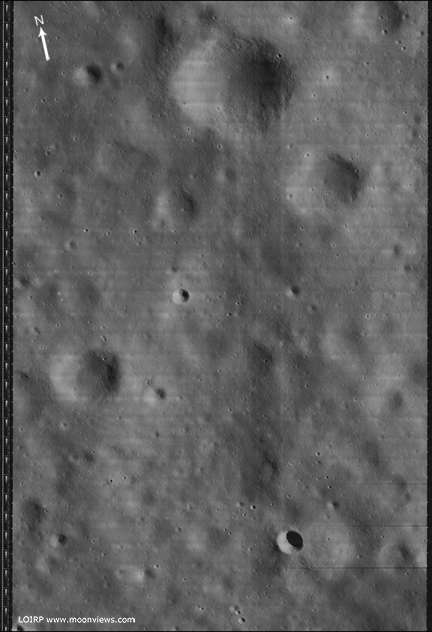
Figure 1 Lunar Orbiter III Frame 133-H2 unlabeled [larger view]
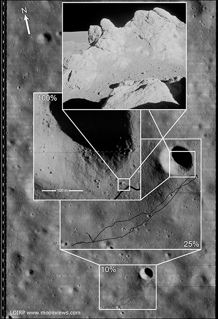
Figure 2 Lunar Orbiter III Frame 133-H2 labeled to show EVA route. [larger view]
This image has been recovered in its original high resolution format from original Lunar Orbiter project data tapes using restored tape drive hardware and will eventually be submitted to the PDS (Planetary Data System). The full resolution is online here at NLSI.
LOIRP Note: We will be putting the full resolution version of this image on the NASA Lunar Science Institute website with the layers preserved for Photoshop for all you folks to have fun with! We only ask that you send us copies of what you do and credit us if you publish it anywhere.
For more information on the Lunar Orbiter Image Recovery Project (LOIRP) visit https://moonviews.wpenginepowered.com
For information on NASA’s Lunar Science Institute visit http://lunarscience.arc.nasa.gov/
Related Links
Apollo 14 Surface Operations Overview
Apollo 14 Preliminary Science Report
Apollo 14 Mission Report
Apollo 14 Lunar Surface Journal
Apollo Landing Sites Mapped by Chandrayaan

Nearly 40 years after Nasa’s Apollo flights, which put a man on the moon, India’s Chandrayaan mission launched on October 22, 2008, recently did something unique this week it mapped the landing sites of the six Apollo missions on the moon and the process ended on Saturday. The Apollo flights were launched between July 1969 and December 1972. [More]
Lunar Orbiter Imagery and Apollo Landing Site Selection
Source: Apollo Expeditions to the Moon Chapter 5.5 – Mapping and Site Selection
Meanwhile the third member of the automated lunar exploration team had already completed its work. The fifth and last Lunar Orbiter had been launched on August 1, 1967, nearly half a year earlier. When JPL and Hughes began to experience difficulties with Surveyor development, and with the Centaur in deep trouble, NASA decided to back up the entire proaram with a different team and different hardware. The Surveyor Orbiter concept was scrapped, and NASA’s Langley Research Center was directed to plan and carry out a new Lunar Orbiter program, based on the less risky Atlas-Acena D launch vehicle. Langley prepared the necessary specifications and Boeing won the job. Boeing’s proposed design was beautifully straightforward except for one feature, the camera. Instead of being all-electronic as were prior space cameras, the Eastman Kodak camera for the Lunar Orbiter made use of 70-mm film developed on board the spacecraft and then optically scanned and telemetered to Earth. Low-speed film had to be used so as not to be fogged by space radiation. This in turn required the formidable added complexity of image-motion compensation during the instant of exposure. Theoretically, objects as small as three feet could be seen from 30 nautical miles above the surface. If all worked well, this system could provide the quality required for Apollo, but it was tricky, and it barely made it to the launch pad in time to avoid rescheduling.

The youngest big crater on the Moon is Tycho, which is about 53 miles across and nearly 3 miles deep. These Orbiter V photographs reveal its intricate structure. (Area in the rectangle above is pictured in higher resolution below.) A high central peak arises from the rough floor, and the crater wall has extensively slumped. The comparative scarcity of small craters within Tycho indicate its relatively recent origin. Flow features seen in both pictures could have been molten lava, volcanic debris, or fluidized impact-ejected material. Surveyor VII landed about 18 miles north of Tycho, in the area indicated by the white circle above. Enlargements of these pictures show an abundance of fissures and large fractured blocks, particularly near the uppermost wall scarp.
Continue reading “Lunar Orbiter Imagery and Apollo Landing Site Selection”
Apollo 17 Transcript – Possible Impact
The NASA Lunar Impact Monitoring Program, Rob Suggs Space Environments Team Lead and NASA Meteoroid Environment Office May 28, 2008
NASA Apollo 17 transcript discussion is given below (before descent to lunar surface):
03 15 38 09 (mission elapsed time) (10 Dec 1972, 21:16:09 UT – possible Geminid)
LMP Hey, I just saw a flash on the lunar surface!
CC Oh, yes?
Geminids 12/13/1972
LMP It was just out there north of Grimaldi [mare]. Just north of Grimaldi. You might see if you got anything on your seismometers, although a small impact probably would give a fair amount of visible light. CC Okay. We’ll check. LMP It was a bright little flash right out there near that crater. See the [sharp rimed] crater right at the [north] edge of [the] Grimaldi [mare]? Then there is another one [i.e., sharp rimed crater] [directly] north of it [about 50km]- fairly sharp one north of it. [That] is where there was just a thin streak [pin prick] [flash?] of light.
CC How about putting an X on the map where you saw it? LMP I keep looking for — yes, we will. I was planning on looking for those kind of things….
Apollo 15 landing area

An enlarged Lunar Orbiter photograph of the Apollo 15 landing area in the Hadley-Apennine region on the nearside of the Moon. The overlay indicates the location of the numerous informally-named surface features. These names will facilitate understanding the verbal descriptions from the astronauts during their lunar surface extravehicular activity.

Larger image
Lunar Orbiter photograph, enlarged, showing the Hadley-Apennine Apollo 15 landing site, with numerous craters and other small features named to aid discussion between EVA Astronauts and MCC. (July 16, 1971)
Apollo Landing Site Ellipse II-P-6

Ellipse II-P-6, located in western Mare Tranquillitatis. The center coordinates for the ellipse are 00 degrees 45 minutes north longitude and 23 degrees 37 minutes east latitude. It was the sixth primary site photographed by Lunar Orbiter II. Surveyor V landed approximately 26 kilometers to the north-northwest from the center of the ellipse.
Apollo Landing Site Ellipse II-P-2

Photograph of surface of moon showing eastern Mare Tranquillitatis Description: Ellipse II-P-2, located in eastern Mare Tranquillitatis. The center coordinates for the ellipse are 2 degress 40 minutes north longitude and 34 degrees 00 minutes east latitude. It was the second primary site photographed by Lunar Orbiter II. It is the eastern most of the Set C Mission I sites.