Arizona State University Lunar Orbiter Maps the Moon With EMC Isilon

EMC Corporation (NYSE: EMC), the world leader in information infrastructure solutions, today announced that the Arizona State University School of Earth and Space Exploration (SESE) has deployed EMC Isilon(R) scale-out NAS to power the processing and analysis of tens of thousands of lunar images from NASA’s Lunar Reconnaissance Orbiter (LRO), with the aim of identifying ideal landing sites and areas of permanent shadow and illumination on the Moon’s surface. Using Isilon’s NL-Series, powered by the OneFS(R) operating system, SESE has consolidated its entire image processing, analysis and archiving workflow onto a single file system, simplifying big data management to reduce operating costs and increase research productivity. Additionally, using Isilon’s SyncIQ(R) asynchronous replication application, SESE can replicate its massive collection of lunar imagery to a second Isilon NL cluster to ensure maximum data reliability and availability.

Continue reading “Arizona State University Lunar Orbiter Maps the Moon With EMC Isilon”

Lunar Reconnaissance Orbiter Data Release 4

The NASA Planetary Data System is pleased to announce a new delivery of Lunar Reconnaissance Orbiter (LRO) data for the following instruments: CRaTER, DLRE, LAMP, LEND, LOLA and LROC. Mini-RF and SPICE data will be released shortly. In general, LRO Release 4 includes data collected between June 15 and September 14, 2010. The following data sets will include revisions of previously released products, as explained in the errata.txt file for each data set:
LOLA EDR, RDR, GDR: all previously released data revised LEND EDR, RDR: data products acquired July 3-June 14, 2010 are revised Diviner RDR: data products acquired July 5-June 15, 2010 are revised
To access the above data, please visit the following link: http://pds.nasa.gov/subscription_service/SS-20101215.html
PDS offers two services for searching the LRO archives:
The Planetary Image Atlas at the Imaging Node allows selection of LRO data by specific search criteria. http://pds-imaging.jpl.nasa.gov/search/lro/
The Lunar Orbital Data Explorer at the Geosciences Node allows searching and downloading of LRO data and other lunar orbital data sets (Clementine and Lunar Prospector). http://ode.rsl.wustl.edu/moon/ Source” Planetary Exploration Newsletter

The Earth As Seen From The Moon by LRO


View larger image
The Earth as seen from the Moon! LROC NAC mosaic of images snapped on 12 June 2010 during a calibration sequence (Images E130954785L and E130954785R). Credit: NASA/Goddard/Arizona State University
Editor’s note: According to Mark Robinson at ASU “The full res version has a pixel scale of 3.7 km. The lead in web posting has a pixel scale of 12.4 km. If you follow the link you can get to the full resolution mosaic on the LROC webpage. Since this is an orthographic view the pixel scale is calculated at the center of the disc, the resolution falls off as a cosine function towards the limb.” Zoom in on the image here.
All cameras are susceptible to scattered light. You may have seen scattered light in pictures you have taken looking towards the Sun. Sunlight reflects off the optics and sometimes off the structure of the lens, and often appears as a gradient of brightness across the image. Attaching a baffle to your camera, like we did with the LROC Wide and Narrow Angle Cameras, can minimize this effect. More subtle effects are often present but usually you simply just don’t notice artifacts because of strong color contrasts in the scene. Since the Moon has only very small color contrasts, the LROC team must characterize even subtle scattered light effects within the 7-color Wide Angle Camera (WAC) images. Changes in composition (rock types) result in subtle differences of color, typically about 10% or less. For scientists to make accurate interpretations of WAC color maps, the amount of scattered light must be quantified (and preferably corrected). One way of measuring scattered light is imaging a bright object against a dark background. From the Moon, the Earth serves that function well. While a series of WAC calibration images of the Earth were being acquired, the Narrow Angle Camera (NAC) was shuttered to capture this spectacular Earth view. The bottom of the Earth was clipped because the prediction of the exact time when the cameras’ fields of view would cross the Earth was off by a few seconds.
Since the NAC acquires only one line of a picture at a time, the spacecraft had to be nodded across the Earth to build up the scene. The NAC Earth view is actually a mosaic of NAC-Left and NAC-Right images put together after calibration. The distance between the Moon and the Earth was 372,335 km when the picture was taken, with a pixel scale of about 3.7 km, and the center of this view of Earth is 25°N latitude, 114°E longitude (a few hundred kilometers north of Hong Kong).


View larger image
AP: Arabian Peninsula; CS: Caspian Sea; H: Himalayan Mountains; L: Lena River; I: Indian Ocean; A: Australia; J: Japan; P: Pacific Ocean; large yellow arrow indicates approximate position of the North Pole. Credit: NASA/Goddard/Arizona State University
It was a beautiful clear summer day over the North Pole. You can see ice covering most of the Arctic Ocean with a few leads of open water (dark) starting to open up. If you look very close you can follow the Lena River upstream from the Arctic Ocean all the way to Lake Baikal. Much of the Middle East was clear and you can trace spectacular swirl patterns of folded rock layers through Iran, Afghanistan, and Pakistan. These mountains formed as the Eurasian and Arabian tectonic plates collided.
Browse the full-sized image at the LRO Camera website maintained by Arizona State University.

Citizen Science and The Moon

NASA Invites Public to Take Virtual Walk On The Moon
“More than 37 years after humans last walked on the moon, planetary scientists are inviting members of the public to return to the lunar surface as “virtual astronauts” to help answer important scientific questions. No spacesuit or rocket ship is required – all visitors need to do is go to www.moonzoo.org and be among the first to see the lunar surface in unprecedented detail. New high-resolution images, taken by NASA’s Lunar Reconnaissance Orbiter Camera (LROC), offer exciting clues to unveil or reveal the history of the moon and our solar system.”

Lunakhod 2 Found

Western researcher solves 37-year old space mystery, University of Western Ontario
“A researcher from The University of Western Ontario has helped solve a 37-year old space mystery using lunar images released yesterday by NASA and maps from his own atlas of the moon. Phil Stooke, a professor cross appointed to Western’s Departments of Physics & Astronomy and Geography, published a major reference book on lunar exploration in 2007 entitled, “The International Atlas of Lunar Exploration.”

LOIRP and LRO Confirm That Humans Walked on the Moon

Yesterday the LRO team released a new image of the Apollo 14 landing site. You can clearly make out the paths that the crew walked as well as the location of the Apollo 14 Antares Lunar Module Descent Stage.
In June 2009 LOIRP issued its own view and analysis of this landing site – as seen by Lunar Orbiter III back in 1967.
Comparing our high resolution image of the site with that taken by LRO clearly shows no feature where Antares’ Descent Stage now stands [larger image]. While the resolution of the Lunar Orbiter image (0.8 meters/pixel) would probably not reveal astronaut tracks in great detail, we’re rather certain that it would have seen an object the size of Antares’ Descent Stage.
As such, we’re pretty certain that the Apollo 14 mission landed on the Moon!

LRO’s First Images Of The Moon

First Moon Images From NASA’s Lunar Reconnaissance Orbiter
“NASA’s Lunar Reconnaissance Orbiter has transmitted its first images since reaching the moon on June 23. The spacecraft’s two cameras, collectively known as the Lunar Reconnaissance Orbiter Camera, or LROC, were activated June 30. The cameras are working well and have returned images of a region in the lunar highlands south of Mare Nubium (Sea of Clouds). As the moon rotates beneath LRO, LROC gradually will build up photographic maps of the lunar surface.
“Our first images were taken along the moon’s terminator — the dividing line between day and night — making us initially unsure of how they would turn out,” said LROC Principal Investigator Mark Robinson of Arizona State University in Tempe. “Because of the deep shadowing, subtle topography is exaggerated, suggesting a craggy and inhospitable surface. In reality, the area is similar to the region where the Apollo 16 astronauts safely explored in 1972. While these are magnificent in their own right, the main message is that LROC is nearly ready to begin its mission.”

Lunar Orbiter Image Recovery Project (LOIRP) Releases New High Resolution Image of The Apollo 14 Landing Site With EVA Details

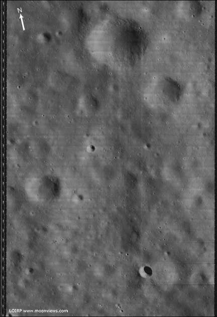
This photo (Frame 133-H2) of the future Apollo 14 landing site was taken by Lunar Orbiter III on 20 February 1967 at an orbital altitude of 46.7 km. The resolution of the image is around 0.8 meters per pixel. The area covered by this image is 4.52167 x 5.77666 km.
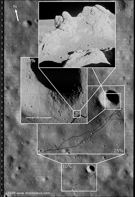
Figure 1 shows the image unlabeled. In Figure 2 we have overlaid the EVA route upon this image so as to show where the crew set foot. While the crew were supposed to visit Cone crater they stopped 20 meters short of doing so due to some confusion as to their exact location. That said, they did visit some large rocks located adjacent to Cone crater’s rim. The enlargement of this Lunar Orbiter image clearly shows some large rocks poised near the crater’s rim. The inset photo shows the largest outcropping as photographed by the crew on the surface.
NOTE: We originally posted these files in an incorrect orientation. This was due to how the images originally show up when they are retrieved from the original tapes. Thanks to all of you eagle-eyed viewers we caught that. We have replaced those earlier files with ones that are correctly oriented to North, South, East, and West.

Figure 1 Lunar Orbiter III Frame 133-H2 unlabeled [larger view]

Figure 2 Lunar Orbiter III Frame 133-H2 labeled to show EVA route. [larger view]


This image has been recovered in its original high resolution format from original Lunar Orbiter project data tapes using restored tape drive hardware and will eventually be submitted to the PDS (Planetary Data System). The full resolution is online here at NLSI.
LOIRP Note: We will be putting the full resolution version of this image on the NASA Lunar Science Institute website with the layers preserved for Photoshop for all you folks to have fun with! We only ask that you send us copies of what you do and credit us if you publish it anywhere.
For more information on the Lunar Orbiter Image Recovery Project (LOIRP) visit https://moonviews.wpenginepowered.com
For information on NASA’s Lunar Science Institute visit http://lunarscience.arc.nasa.gov/
Related Links
Apollo 14 Surface Operations Overview
Apollo 14 Preliminary Science Report
Apollo 14 Mission Report
Apollo 14 Lunar Surface Journal