Technoarchaeology: Finding The Right Image in a Room Full of Tapes

Image: a portion of our set of Lunar Orbiter data tapes at McMoon’s – an abandoned McDonalds onsite at NASA Ames Research Park, home of the LOIRP – Lunar Orbiter Image recovery Project.
Here at the LOIRP (Lunar Orbiter Image Recovery Process) project there are two different phases of the image retrieval process that are distinct from each other. The second phase, the production of the vast majority of all the of the Lunar Orbiter images, will simply involve putting tapes on the tape drive machines, acquiring the data, and processing them into images.
However, we’re still in the first phase of the project where we need to search through tapes in a painstaking fashion just to find the images we are interested in downloading. Once we find what we are looking for, downloading is a snap and can be done in a matter of hours.
Finding the images using a jumbled nomenclature and labeling system last used more than 40 years ago is part of what we call “Technoarchaeology”.

Continue reading “Technoarchaeology: Finding The Right Image in a Room Full of Tapes”

LOIRP Releases Enhanced Restored Version of the “Image of the Century” Plus Additional Subframes of Crater Copernicus

This is a re-release of Life Magazine’s “Image of the Century” from 1966. The performance of our hardware and software image processing methods has been significantly enhanced to remove some of the banding artifacts that are derived from imperfections in the spacecraft image scanning hardware. This image of Copernicus crater was taken from a spacecraft altitude of 45 km (27.1 miles) and is approximately 207.7 km (~125 miles) to the center of the image.
An interesting aspect to this image is that with this oblique view, recent impacts of small craters have much more brightness than older craters of the same size. This suggests the value of oblique photography in doing crater aging studies as well as multispectral remote sensing of excavated materials from the craters. You can view a larger version [900 K JPG] of this image on your screen here. You can download the full resolution image [505 MB TIFF] here at the NLSI.

Continue reading “LOIRP Releases Enhanced Restored Version of the “Image of the Century” Plus Additional Subframes of Crater Copernicus”

Lunar Orbiter In The News

Local engineer critical to NASA’s Lunar Orbiter project
“A crescent earth appears suspended in black space in the upper portion of the image with the lunar landscape dominating the foreground. That image may have never been captured if not for a Boeing crew member who suggested turning the spacecraft around so the camera pointed toward Earth, a move not designed in the original mission playbook, explained Knittel. “It was pretty awesome,” Knittel recalled about the first time he saw the photograph which was taken Aug. 23, 1966. The image transmitted back to Earth from the satellite in several separate strips of 35-mm film and was eventually assembled side by side to create the finished photo. Since the picture arrived in pieces, at first the crew monitoring its arrival only saw the moon surface and were momentarily dejected believing that the camera on board the spacecraft had missed photographing the earth, said Knittel. Then the earth’s round image slowly appeared. “When they saw that picture, I understand that there were a lot of teary eyes,” he said. “It was sort of like birthing a baby, I guess. It was such a big event.”

LOIRP Releases Recovered Lunar Orbiter V Image of “Full Earth”


This image (LO_V-5030) of Earth was taken on 8 August 1967 at 09:05:11 GMT by the Lunar Orbiter V spacecraft in orbit around the Moon at an altitude of 5,872.85 km. This image has been described as being the first image ever taken of a “full Earth” from space. [Larger image]
Lunar Orbiter V was launched on 1 August 1967 arrived in a nearly polar orbit on 5 August at 12:48 p.m. EDT. Images were taken between 6-19 August and were sent back to Earth on 27 August 1967.
This is the orientation of Earth as Lunar Orbiter V snaped its photo from Lunar Orbit


It is easy to make out a number of geographic features in this image. [Larger image]


In addition, you can see that the detail of the clouds – especially over the Indian Ocean is much greater in this image. Further processing of this image should yield even greater detail. [Larger image]


This is one of only three images of the Earth taken from the five lunar orbiter spacecraft. In its full resolution form, you can easily see Sicily, Cyprus, the Caspian Sea, lake Bakial, and other features such as the Nile delta. The Chinese coast is visible on the upper right as well as India and Ceylon in the center of the image. In the lower right the Indonesian islands are also visible. The estimated resolution of the image on the Earth is approximately 5 kilometers.
This is the 2 inch tape reel on which this image was stored. Note on the label [much larger image] that “L.O.E.” refers to “Lunar Orbiter E” aka “Lunar Orbiter V”. The tape was recorded on day 238 of 1967 local time i.e. 26 August 1967. Starting at 06:34:38 GMT and ending at 07:26:10 GMT


This image was not in the original mission plan. According to Destination Moon: A History of the Lunar Orbiter Program (NASA TM X-3487):

“Photography commenced at 7:22 p.m. EDT on August 6. At this time the spacecraft took its first photograph of the Moon at a distance of about 6,000 kilometers from the lunar surface. The target was a previously unknown area of the far side. Then it executed a maneuver early on August 7 [294] that lowered the perilune to 100 kilometers while maintaining a 6,023-kilometer apolune. The spacecraft continued farside photography, exposing eighteen out of nineteen frames during the first part of the mission. The nineteenth was a “film set” frame, moved through the photo subsystem in an eight hour interval to prevent film from setting and Bimat from drying out. While this was a planned item In the film’s budget, the decision which program officials made early on August 7 changed the next scheduled “film set” frame significantly. They decided to use it to take a photograph of the Earth with the 610 mm high-resolution camera lens instead of passing It unexposed through the system.
Site VA-9, as the Earth photograph was identified, had not been in the original plan. Program officials decided, however, that the position of Lunar Orbiter V relative to the Moon and the Earth and the Earth’s position relative to the Sun afforded a very fine opportunity to take such a picture. The Langley program planning staff together with flight controllers implemented a plan to make an Earth photograph when the spacecraft neared apolune between orbits 7 and 8. Since the spacecraft’s orbit geometry kept it in view of Earth at all times, the Moon would not appear in [295] the photograph.
Exactly seven hours twenty-three minutes elapsed between the exposure of the previous photograph of Site VA-8 and the moment when Lunar Orbiter V’s camera made the historic picture of the nearly full Earth on August 8 at about 9:05 Greenwich Mean Time. Shutter speed was 1/100 second, but the Earth’s high albedo caused some overexposure of the film. This was unavoidable. Later Langley Research Center photography specialists successfully applied image enhancement techniques, using magnetic tape video records of the readout of the photograph, to bring out details which would not have shown up in a negative reconstructed from the raw readout data. (Note that enhancement techniques did not involve any “doctoring” of photographic data in order to “show” something which was not there.)
Approximately 149° of arc of the Earth’s surface appeared clearly in the photograph. It illustrated the possible synoptic weather observations that a satellite could conduct in cislunar space or that could be made from the Moon.”

This image has been recovered in its original high resolution format by LOIRP staff from original Lunar Orbiter project data tapes using restored tape drive hardware and will eventually be submitted to the PDS (Planetary Data System).
A full resolution version of this image is now online at the NASA Lunar Science Institute here (1.07 GB TIFF)
The first image recovered by LOIRP was the iconic “Earthrise” image taken by Lunar Orbiter a year prior to this Lunar Orbiter V image.
The Lunar Orbiter Image Recovery Project (LOIRP) is located at the NASA Ames Research Center in Moffett Field, CA. Funding and support for this project has been provided by NASA Exploration Systems Mission Directorate, NASA Innovative Partnerships Program, NASA Lunar Science Institute, NASA Ames Research Center, Odyssey Moon LLC, SkyCorp Inc., and SpaceRef Interactive Inc.
For more information on the Lunar Orbiter Image Recovery Project (LOIRP) visit https://moonviews.wpenginepowered.com
For information on NASA’s Lunar Science Institute visit http://lunarscience.arc.nasa.gov/
For information on NASA’s Exploration Systems Mission Directorate visit http://www.nasa.gov/exploration/

LOIRP Featured by National Geographic

MOON PICTURES: 1960s Orbiter Images Restored, National Geographic
All these steps took their toll on the quality of the images: Much like making a photocopy of a photocopy, the images of the moon created 40 years ago were fairly fuzzy and lacking in detail. But some NASA scientists had the foresight to make magnetic tape recordings of the radio-wave transmissions mid-way through the process. Now, after recovering the decades-old recordings and refurbishing outdated tape drives, a team of volunteers has begun digitizing the most famous images from the 1960s Lunar Orbiter missions with much-improved clarity and detail.
APOLLO 11: New Before-and-After Photos of Moon Bases, National Geographic
“Despite extensive restoration efforts, this photo is fuzzier and grainier than many of the restored 1960s orbiter images because of repeated viewings of the magnetic tape on which the photo was recorded.”

Lunar Orbiter In The News

Kodak has played big role in space program, Democrat and Chronicle
“Kodak designed and built the cameras and film processing used in the five lunar orbiters sent to photograph the moon’s surface in 1966 and 1967 in preparation for the manned landing. Those orbiters shot panoramic strips of the lunar surface and transmitted them back to Earth before the orbiters crashed into the moon, said Todd Gustavson, curator of technology at the George Eastman House.”
To the Moon – with extreme engineering – Spontaneous, improvised – would it be allowed to happen now?, The Register
“It’s a temptation, watching many of the 40th Anniversary retrospectives, to think of the Apollo space program as a triumph of power and industrial might. The superpowers’ space programs were, of course, political and chauvinistic, designed to showcase national wealth. But there’s a better way of looking at the program, Dennis Wingo reminded me recently. Masses of money helped put man on the Moon of course, but the Moon program is really a tale of engineering improvisation and human organisation. … The Lunar Orbiter astonishes even today. It had to take pictures, scan and develop the film on board, and broadcast it successfully back to earth. Naturally, the orbiter had to provide its own power, orient itself without intervention from ground control, and maintain precise temperature conditions and air pressure for the film processing, and protect itself from solar radiation and cosmic rays – all within severe size and weight constraints. This was far beyond the capabilities of the newest spy satellites, which back then returned the film to earth in a canister, retrieved by a specially kitted-out plane. The Orbiter challenge was the Apollo challenge in miniature.”

Damaged Tape and Murky Moon Views


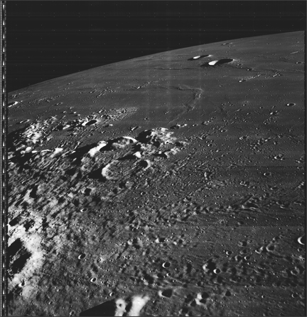
Image: Our retrieved image with the location of Apollo 11’s Eagle Descent Stage.
With the 40th anniversary of Apollo 11’s landing on the Moon upon us, everything old is new – or so it would seem. Yesterday we saw digitally re-mastered footage released showing the first steps on the Moon in unprecedented clarity. Also this was made from a copy that itself was a copy. The original video, recorded live as the Moon walks were underway has slipped into history – either misfiled or, more likely, erased and reused years later – much like a floppy disk. That said, the new footage does provide a window into the past with detail heretofore unseen.
Another place where windows are being opened into the past is the Lunar Orbiter Image Recovery Project (LOIRP) housed at NASA Ames Research Center. Utilizing ancient FR-900 tape drives, thousands of pounds of long forgotten image tapes, lots of loaned help including retired engineers and scientists, some money (from NASA ESMD, ARC, IPP, and NLSI, SkyCorp, and SpaceRef Interactive, and Odyssey Moon) and an old abandoned McDonalds restaurant (it was available – we call it “McMoons”), we’ve been able to bring these images back to life at resolutions greater than ever seen before. In many cases, until Lunar Reconnaissance Orbiter (LRO) takes new images, thee tapes represent the highest resolution images of the Moon ever taken from orbit.
As we ponder the sad news that the original Apollo 11 video has been lost, it is important to note that our Lunar Orbiter tapes might otherwise have been destroyed several years ago had not a stop order been placed on their destruction due to NASA’s search for Apollo 11 tapes and data. One project’s sad news is another’s execution reprieve.
Among our successes has been bringing the iconic Earthrise and Copernicus back to life in unprecedented detail. This time we need to report a major disappointment.
We recently released two Apollo landing site images – Apollo 12 and Apollo 14 and had embarked upon getting an nice crisp image of the Apollo 11 landing site in time for the anniversary.
Alas, unlike the unprecedented resolution we obtained for these two sites, Apollo 11 was a let down. The image is murky and far less clear than previous images. This is not due to the Lunar Orbiter spacecraft or our restored hardware. Rather, we expect, it had to do with someone playing this tape years ago and getting it jammed for an instant. Alas, the interesting part of this tape is framelet 411 which shows the Apollo 11 landing site. So, if there was a natural place on this tape to be paused, rewound, and played again and again and again, it is this location. Little surprise that the chance for damage to this portion of the tape occurred.
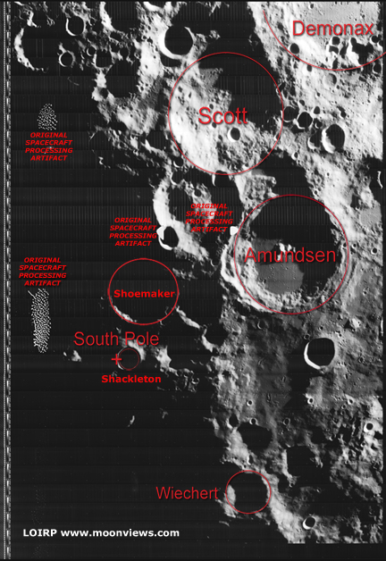
Our collection of tapes covers the entire five mission Lunar Orbiter project. While we are getting better at deciphering the nomenclature and labeling on the tapes, we still have much to learn. We can now find a specific tape and image in a straight forward process but have still only scratched the surface. And, paradoxically, we seem to have more tapes marked “Lunar Orbiter V” than we need to contain all of the images from that mission. We suspect that we have two (or more) archival collections mixed in or (for some reason) multiple copies of the same images. The only way to know for sure is to look at every tape – one by one.
The path to getting this Apollo 11 landing site image was complicated. The image was taken by Lunar Orbiter V on 12 August 1967 at 22:21:13.809 GMT at an altitude of 98. km. Properly retrieved, the resolution of our image should be 2.387 meters per pixel.
After our first round of image retrievals, the heads for our FR-900 tape drive needed to be refurbished. This is an expensive and time consuming process with only one or two places in the world capable of doing it. With the heads refurbished we were prepared to run the tape. As we did we found out that our custom made frame grabber had a bad chip which needed to be replaced.
Once the gear was good to go, the process of running the tape began. There was an ominous note on the tape can that a section of the tape might be damaged. We soon discovered that indeed there was some damage to a 4 minute segment and it was the portion we were most interested in.
Undaunted, Ken Zin, our experienced video tape drive engineer, Al Sturm our electronics guru, and Austin Epps, our vigilant student intern worked long hours to get everything working to see what sort of image we could get. Austin ran the tape multiple times os as to get multiple images we could use to produce a super resolution image of the landing site.
Despite this attempt to coax a little clarity out of the noise, the damage to the tape precluded an image of the quality we had hope for – and had achieved for other images. That disappointment aside, we feel that it is important to show our failures and disappointments as well as our crowning achievements. As you will see when you compare it to the best Lunar Orbiter images, the resolution is low. Yet if you compare it with the new LRO images you can clearly see that something appeared in the image and that the regolith was disturbed around that object (humans).
We will be combing through the Lunar Orbiter tapes this weekend with the hope that there is another (hopefully undamaged) version of this image.
We feel that it is equally important to reveal our failures and disappointments as it is to crow about our successes. We expect to have many of both.
Such is the curse of Apollo 11 – for an event so epic in its nature, the frail means where by we captured it and the planning that led up to it – are fleeting. One more reason why all of this fragile history needs to be maintained with constant vigilance – else we lose all of this to the dust of time.
For more information on the Lunar Orbiter Image Recovery Project (LOIRP) visit https://moonviews.wpenginepowered.com
For information on NASA’s Lunar Science Institute visit http://lunarscience.arc.nasa.gov/


Figure 1 Our retrieved image with the location of Apollo 11’s Eagle Descent Stage.


Figure 2 Comparing our retrieved image and that scanned by the USGS


Figure 3 Comparing our retrieved image, one scanned by the USGS, and LRO’s recent image.

Lunar Orbiter Image Recovery Project (LOIRP) Releases New Image of Apollo 12/Surveyor III Landing Site

This image LO3-154-H was taken by Lunar Orbiter III on 20 February 1967 and shows the landing site for both Surveyor III (landed 20 April 1967) and Apollo 12 (landed 19 November 1969).
Figure 1 shows the region without labels. Figure 2 shows major features plus EVA routes.

Figure 1: Apollo 12/Surveyor III landing site as seen by Lunar Orbiter III (larger image)

Figure: 2 Apollo 12/Surveyor III landing site as seen by Lunar Orbiter III with prominent features and EVA routes (larger image)


This image has been recovered in its original high resolution format from original Lunar Orbiter project data tapes using restored tape drive hardware and will eventually be submitted to the PDS (Planetary Data System).
LOIRP Note: We will be putting the full resolution version of this image on the NASA Lunar Science Institute website with the layers preserved for Photoshop for all you folks to have fun with! We only ask that you send us copies of what you do and credit us if you publish it anywhere.
For more information on the Lunar Orbiter Image Recovery Project (LOIRP) visit https://moonviews.wpenginepowered.com
For information on NASA’s Lunar Science Institute visit http://lunarscience.arc.nasa.gov/

Lunar Orbiter Image Recovery Project (LOIRP) Releases New Image of the Moon’s South Pole

This image was taken by Lunar Orbiter IV in May 1967 and shows the south pole of the Moon. Figure 1 shows the region without labels. Figure 2 shows major features plus notation regarding processing artifacts from the spacecraft’s film processing system. The moon’s south pole is located near the rim of Shackleton Crater.
Adjacent to the south pole is Shoemaker crater named in honor of famed planetary geologist Eugene Shoemaker. The Lunar Prospector spacecraft, carrying some of Shoemaker’s ashes, was deliberately crashed in this crater in an attempt to see if any water ice would be thrown up by the impact.
The Lunar CRater Observation and Sensing Satellite (LCROSS) will be targeted to impact at the south pole of the moon. As such, the moon’s polar regions are of great interest right now.

Figure 1 South Pole of the moon as seen by Lunar Orbiter IV (larger image)

Figure 2 South Pole of the moon as seen by Lunar Orbiter IV with prominent features and processing artifacts identified (larger image)


This image has been recovered in its original high resolution format from original Lunar Orbiter project data tapes using restored tape drive hardware and will eventually be submitted to the PDS (Planetary Data System).
LOIRP Note: We will be putting the full resolution version of this image on the NASA Lunar Science Institute website with the layers preserved for Photoshop for all you folks to have fun with! We only ask that you send us copies of what you do and credit us if you publish it anywhere.
For more information on the Lunar Orbiter Image Recovery Project (LOIRP) visit https://moonviews.wpenginepowered.com
For information on NASA’s Lunar Science Institute visit http://lunarscience.arc.nasa.gov/

Lunar Orbiter Image Recovery Project (LOIRP) Releases New High Resolution Image of the Ocean of Storms


Larger version
The Lunar Orbiter Image Recovery Project (LOIRP) has released a newly-retrieved, high resolution image taken of the lunar surface 42 years ago.
This image was taken by Lunar Orbiter III (LPI data) in February 1967. This oblique photo shows the region around the crater Galilaei and Planitia Descensus in Oceanus Procellarum (the Sea of Storms). In the upper center of the image you can see the Great Wall of Procellarum.
This image has been recovered in its original high resolution format from original Lunar Orbiter project data tapes using restored tape drive hardware and will eventually be submitted to the PDS (Planetary Data System).
LOIRP Note: We will be putting the full resolution version of this image on the NASA Lunar Science Institute website with the layers preserved for Photoshop for all you folks to have fun with! We only ask that you send us copies of what you do and credit us if you publish it anywhere.
For more information on the Lunar Orbiter Image Recovery Project (LOIRP) visit https://moonviews.wpenginepowered.com
For information on NASA’s Lunar Science Institute visit http://lunarscience.arc.nasa.gov/

KTVU: Old NASA Tapes Reveal Stunning New Moon Images; Resolution Unparalleled

Old NASA Tapes Reveal Stunning New Moon Images; Resolution Unparalleled
KTVU looked at several images, and the detail and clarity are astonishing. It’s the difference between grainy 35mm film with several generations of degradation, and the 70mm film original.
“Dennis Wingo brought up NASA’s publicly released photo from August 23, 1966, called “Earthrise.” Time Magazine called it the “Photo of the Century” and it is certainly amazing even today. But on the next screen Wingo showed the digitized version from the original tracking station tapes. Zooming in on the first version, Earth looks a bit fuzzy, though you can make out cloud patterns. On the recovered version, you can see fog along the Chilean coast, ice floes near the Antarctic. It is truly astonishing.
“Using these and some other 1966 images, we may be able to help push NASA’s climate data back in time a full decade, which will help with climate change studies,” says Wingo.
On shots of the lunar surface, the first versions show a blurry shadow here, some grayish along the horizon. The digitized recovered image is crisp with the deep black of space hovering over a multi-shaded gray surface, almost as if you were looking out the window of some lunar highrise. You can see rocks the size of an office chair. Sharp shadows and almost a 3D effect.”

Full story and Video at KTVU