
Note: Lunar Orbiter Segment starts at 1:28
“The Lunar Orbiter program was a series of five unmanned lunar orbiter missions launched by the United States from 1966 through 1967. Intended to help select Apollo landing sites by mapping the Moon’s surface, they provided the first photographs from lunar orbit. All five missions were successful, and 99% of the Moon was mapped from photographs taken with a resolution of 60 meters or better… All Lunar Orbiter craft were launched by an Atlas-Agena D launch vehicle. The Lunar Orbiters had an ingenious imaging system, which consisted of a dual-lens camera, a film processing unit, a readout scanner, and a film handling apparatus. Both lenses, a 610 mm narrow angle high resolution (HR) lens and an 80 mm wide angle medium resolution (MR) lens, placed their frame exposures on a single roll of 70 mm film… The film was then processed, scanned, and the images transmitted back to Earth. During the Lunar Orbiter missions, the first pictures of Earth as a whole were taken, beginning with Earth-rise over the lunar surface by Lunar Orbiter 1 in August, 1966.”
Saving History Before It Is Gone
 Fading History: Vintage Films And Photos Crumbling To Dust, Forbes
Between 1966 and 1967, NASA sent five Lunar Orbiter spacecraft to the moon to capture images before the arrival of Apollo 11, which landed on the lunar suface July 20, 1969. Forty years later, while preparing for the historic anniversary, NASA began a frantic search for those images after a well-publicized loss of the original video of the Apollo 11 landing. Fortunately, the Lunar Orbiter tapes were found. Because the compatible tape players hadn’t been manufactured since 1975, it took a multi-year effort to refurbish a player in order to read the obsolete tapes. The results were stunning images at digital resolutions never seen before.
Lunar Orbiter Earthrise Sighting

“I saw that you had posted some Lunar Orbiter I presentation pieces. I own one of them, but until recently didn’t know much about it. In researching the picture, I learned about the story of the tapes. Here is the one that I received in 1984-85 from a nice lady I worked with at the time. It doesn’t have a plaque, or dedication, but seems framed for an executives office. Her husband worked on the project, and this was in his office. He had passed away, and she brought it to work and gave it to me as a gift. She knew I was a big space flight fan and had just got back from a shuttle launch a couple of months back, and figured I would give it a good home. I wished I would have asked more questions at the time, but I was just so surprised by it. This was in Denver, and we were both working at an Ampex sub-contractor at the time.
The picture currently resides in my editing room in my studio/office. Since it is the anniversary of the photo, I snapped a quick pic of it for my facebook page, and thought I’d drop you a note while I was at it. BTW, I love the story of the LOIRP, since I have a fondness for old gear, and technology. I also like the Colorado connection with the video magnetics guys, we were regular customers back in the day. Keep up the good work. I know everyone is all hyped up on Mars, but as a child of the 60’s, I’m all about the moon.”
Scott Sheriff, Director, SST Digital Media
www.sstdigitalmedia.com
Video: Lunar Orbiter Techs Talk About Crater Kepler in 1967
This audio is from a Lunar Orbiter tape made on 24 Feb 1967. In the tape you can hear the techs talking about an image they were expecting to download the next day – an oblique shot of crater Kepler. At one point, one tech says “The Russians said that they saw smoke rising from Kepler but in the medium [resolution image] there is no smoke present.”
Happy Anniversary To Our Older Cousin Telstar
 Bell Labs Celebrates 50th Anniversary of Telstar and Birth of Modern Communications
“Bell Labs, the research arm of Alcatel-Lucent will celebrate one of its great historical achievements with the 50th anniversary of the launch of Telstar I, the world’s first active communications satellite. The launch on July 10, 1962, in partnership with NASA, ushered in the era of modern communications including real-time global telephone service, data communications and TV broadcasting. Telstar I, a sphere roughly a yard in diameter and weighing about 170 pounds, was a technology ‘tour de force,’ incorporating dozens of innovations from Bell Labs, including the transistor and solar panels, and was powered by 3,600 solar cells also invented by Bell Labs in 1954. The satellite could carry 600 voice calls and one black-and-white TV channel.”
Lunar Orbiter’s Classified Heritage
 SAMOS To The Moon: The Clandestine Transfer of Reconnaissance Technology Between Federal Agencies, NRO
“Having acquired, launched, and then terminated work on a near real time imaging satellite, however, NRO officials at that time agreed to consign the SAMOS imaging system to the National Aeronautics and Space Administration (NASA) for use in its deep space exploration program. The surreptitious transfer of this technology, a fact just recently declassified, has remained unknown to many in the NRO and NASA because of the compartmented security measures then in place. It occurred in the following manner.
When in the summer of 1963 NASA requested proposals for a five flight Lunar Orbiter imaging satellite, the Eastman Kodak Company asked for and received permission from the NRO to join The Boeing Airplane Company and bid on the program. In the effort to meet NASA requirements, Eastman would modify its E-1 camera with an 80mm focal length Schneider-Xenotar lens and an off-the-shelf 24-inch telephoto lens procured from Pacific Optical. The two lenses would be bore sighted at the surface of the moon for a planned orbit of about 30 miles altitude. Light would pass through each lens to the film, but the simultaneous images were interspersed with other exposures, and not placed side by side. The camera employed the existing velocity over height sensor to regulate the speed of the focal plane shutter on the 24 inch lens and the between the lens shutter on the 80mm lens, which compensated for image motion. The Boeing Airplane Company, in turn, designed a solar-powered spacecraft stabilized in attitude on three axes that mounted other off-the-shelf hardware, and integrated it with the modified E-1 SAMOS payload.”
Printing The Moon

Between 1966 and 1967 NASA sent five Lunar Orbiter spacecraft to the Moon. Their job was to survey the surface to help determine landing sites for the upcoming Apollo missions. In addition to their recon role, these spacecraft also contributed to the nascent scientific understanding of the Moon.
At the time that the images were taken using film that was actually developed aboard the spacecraft in lunar orbit, the ability to send back imagery was nothing like it is today. The photos were scanned much like news photos of the day and the data was sent back to Earth. The images were then printed out on photographic paper and used to construct maps of the lunar surface. In so doing a lot of data from the original photos was lost. Luckily NASA had the foresight to listen to the suggestions of project engineers such as Charles Byrne and stored the original data on analog tapes.
Some 40 years after these missions were completed the Lunar Orbiter Image Recovery Project (LOIRP) was begun with the intent of using refurbished tape drives and a complete set of original project tapes (over 1,500). Utilizing funding from NASA the LOIRP team was able to return the original drives to operation such that the data on the tapes could be accessed.
By adding modern computer interfaces and data handling techniques, the LOIRP was able to scan and record the data in ways that simply could not have been accomplished in the 1960s. As a result the images that were obtained had a much higher resolution and dynamic range than had been seen to date. Indeed, in many cases, these images often rival or exceed images taken by the Lunar Reconnaissance Orbiter which is currently surveying the Moon.
As clever as we thought we were, we were not the first team to tackle the issue of generating high resolution imagery. Someone tried to do much of what we were doing today – but did so with technology available in the 1960s. We were recently contacted by someone who had seen our project’s Facebook page. His name is Joe Watson and he worked on a project that used computer printers that worked like giant electric typewriters – but using varying sizes of squares instead of letters. With this system and a lot of creativity, Watson and his team created immense high resolution versions of Lunar Orbiter images from which topographic maps were made.
We had heard some vague stories about such projects but were unaware of just how audacious they were. So, in Joe Watson’s own words, here is the story of a precursor of the LOIRP.
Iconic Lunar Orbiter Image of Copernicus Re-released

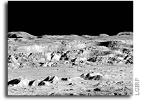
Today an iconic image from the initial exploration of the Moon is being re-released showing detail that could not have been seen using technology available at the time the photo was taken. This image features a dramatic view inside the majestic crater Copernicus – a view that left millions in awe when it was first released.
This image was announced at the First Global Space Exploration Conference, co-sponsored by the AIAA and IAF, in Washington, DC.
Between 1966 and 1967 NASA sent five Lunar Orbiter spacecraft to the Moon. Their job was to survey the surface to help determine landing sites for the upcoming Apollo missions. In addition to their recon role, these spacecraft also contributed to the nascent scientific understanding of the Moon. But every once in a while these spacecraft also served as artists, snapping photos of this nearby world in a way that human eyes had never been able to see before.
Once such image was taken of crater Copernicus on 24 November 1966 by the Lunar Orbiter 2 spacecraft. What made this photo so unique was the oblique angle it was taken at as well the close proximity of the spacecraft to its target. The image was taken at an altitude of 45 km (27.1 miles) at a distance of approximately 207.7 km (~125 miles) from the center of the crater. Instead of looking down, the spacecraft looked sideways at the Moon.
For the first time people saw the Moon as a world with mountains and boulders and other features (some of them strange) that were not apparent from photos where the view was looking straight down. So taken were people at the time that Life Magazine took to calling the photo “The Picture of the Century”. Along with the equally famous Earthrise image taken by Lunar Orbiter 1, the Moon went from being a distant sight in the sky to a world waiting to be explored – in person.
At the time that the images were taken using film that was actually developed aboard the spacecraft in lunar orbit, the ability to send back imagery was nothing like it is today. The photos were scanned much like news photos of the day and the data was sent back to Earth. The images were then printed out on photo graphic paper and used to construct maps of the lunar surface. In so doing a lot of data from the original photos was lost. Luckily NASA had the foresight to listen to the suggestions of project engineers such as Charles Byrne and stored the original data on analog tapes.
Some 40 years after these missions were completed the Lunar Orbiter Image Recovery Project (LOIRP) was begun with the intent of using refurbished tape drives and a complete set of original project tapes (over 1,500). Utilizing funding from NASA, facilities offered by NASA Ames Research Center, and donated effort and resources from SkyCorp Inc. and SpaceRef Interactive Inc., the LOIRP team was able to return the original drives to operation such that the data on the tapes could be accessed.
By adding modern computer interfaces and data handling techniques, the LOIRP was able to scan and record the data in ways that simply could not have been accomplished in the 1960s. As a result the images that were obtained had a much higher resolution and dynamic range than had been seen to date. Indeed, in many cases, these images often rival or exceed images taken by the Lunar Reconnaissance Orbiter which is currently surveying the Moon.
In 2009 LOIRP released its first attempt to retrieve this image of Copernicus. In the ensuing several years the process of calibrating thee tape drives, scanning the tapes, and assembling and processing the imagery has improved to the point that a new attempt to retrieve the image was undertaken.
This project is multi-generational in many ways. The tape drives use original parts and modern components and are connected to monitoring equipment that is itself decades old. All of this is connected to Mac desktop computers running of the shelf software. There are some special tools. Some of the software LOIRP now uses to process these images was written by Charles Byrne – the very same person who suggested that these images be stored on data tapes over 40 years ago.
LOIRP also involves the participation of young people such as Austin Epps and Neulyn Moss in the process of generating and analyzing the images. LOIRP also has a regular series of local students working as interns to assist the project.
It is important to remember that as we look toward the Moon, Mars and other places as future destinations that we are not the first generation to do so. In the 1960s people had the same dreams – and they acted upon them with simpler tools than we have today. There is a lot to be gained from talking to people from that era. They have more than just memories of these days. Unlike many of us today, they know how to actually make their dreams become reality. That advice is timeless and is something that needs to be passed on to a new generation. We take it very seriously at LOIRP. Indeed, had we not done so, we’d never have retrieved these images.
About LOIRP
The Lunar Orbiter Image Recovery Project (LOIRP) is located at the NASA Research Park at Moffett Field, CA. Funding and support for this project has been provided by the NASA Human Exploration Operations Mission Directorate, the NASA Innovative Partnerships Program, the NASA Lunar Science Institute, NASA Ames Research Center, SkyCorp Inc., and SpaceRef Interactive Inc.
For more information on the Lunar Orbiter Image Recovery Project (LOIRP) visit https://moonviews.wpenginepowered.com
For information on NASA’s Lunar Science Institute visit http://lunarscience.arc.nasa.gov/
IMAGES

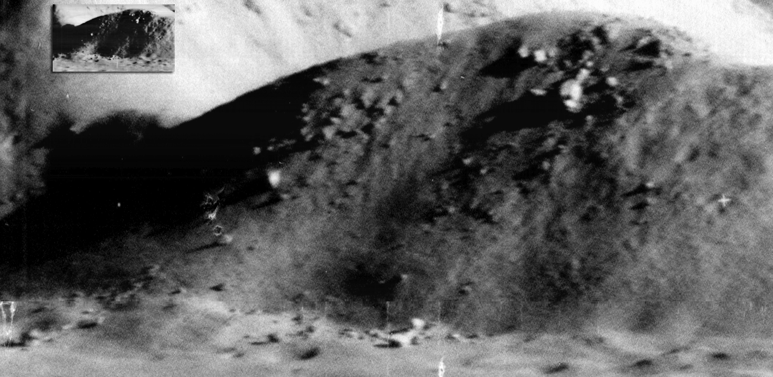
Image: This is the newly reprocessed view of Copernicus. (larger image) (Raw image 683.2MB LINK NOT WORKING) Credit: LOIRP
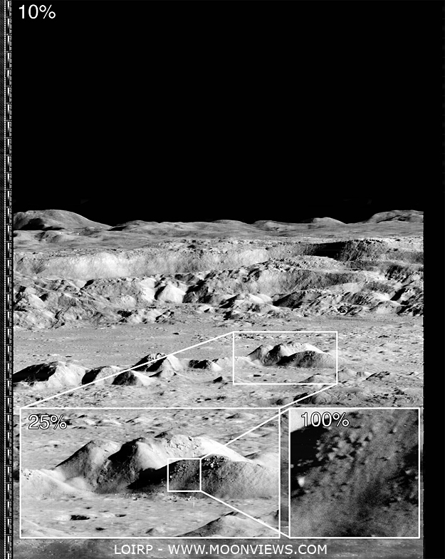
Image: This image shows the magification that is possible with the LOIRP image recovery process (larger image) Credit: LOIRP

Image: If you take the highest resolution image that is available on the LPI Lunar Orbiter site and compare it with the new LOIRP image, the increase in size becomes obvious. Credit: LOIRP

Image: The amount of detail that the new image reveals is clear. Not only is the resolution much higher, but the dynamic range is greater so as to allow gradations in surface texture, shadows, etc. to be much more clearly pronounced (larger image). Credit: LOIRP
Preserving History on the Moon
 NASA Offers Guidelines To Protect Historic Sites On The Moon
“NASA and the X Prize Foundation of Playa Vista, Calif., announced Thursday the Google Lunar X Prize is recognizing guidelines established by NASA to protect lunar historic sites and preserve ongoing and future science on the moon. The foundation will take the guidelines into account as it judges mobility plans submitted by 26 teams vying to be the first privately-funded entity to visit the moon.”
Technoarchaeology: Learning New Things from Old Technology
Technologies that we’ve lost – and the quest to find them again, io9
“I asked NASA Watch’s Keith Cowing about this, and he explained that this is just an urban legend. The schematics are all still around, mostly on microfiche, and any ancient computer files just hold images of the original plans as opposed to now unreadably obsolete data. Still, while the knowledge wasn’t lost, it was certainly forgotten, and worse, it was badly organized. As Cowing – himself working on the rediscovery of old NASA documents with the Lunar Orbiter Image Recovery Project – told me, all this archival information was basically abandoned until NASA’s started working on the Constellation program last decade, and now that that project has been forgotten the information is again beginning to gather dust. If there is a point of disconnect, it’s more in terms of how we understand the information and the different ways in which we approach science forty-five years on:”
“If anything’s missing, it’s actually more the explanation. I mean there is some stuff that will never be found again, but it’s all there, and the stuff that isn’t you can sort of figure out backwards. Sometimes you need the equivalent of a Rosetta Stone, because sometimes the way we think today is not the way they thought back then. Sometimes you need an index or a document that explains how they did things or their nomenclature. That’s the one thing that’s sometimes hard to find is what I call a bridge document, an answer guide to how they did the thing back in the sixties. There’s no FAQ.”
Technoarchaeology: Restored Gemini Program Photos

Source, Gemini VII.
Restored Photos: Project Gemini Comes to Life
“On 23 March 1965, the first of ten crewed Gemini spacecraft was launched carrying it’s crew of two astronauts, Gus Grissom and John Young. The NASA Johnson Space Center and the School of Earth and Space Exploration at Arizona State University today proudly unveil the Project Gemini Online Digital Archive. The archive contains the first high-resolution digital scans of the original Gemini flight films, now available in several formats with a click of your mouse.”
“Apollo 18”, LOIRP, and Conspiracies
 Apollo 18: A Review And Interview With Technical Advisor Gerry Griffin
“People’s fascination with space conspiracies has always intrigued me. Facts are irrelevant once someone has made up their mind about something – usually involving the big evil government covering something up – usually evidence of aliens visiting us. I have some personal experience with this via my involvement with the Lunar Orbiter Image Recovery Project (LOIRP) which is being run on a low budget basis outside the gate at NASA Ames Research Center in a McDonalds hamburger joint that closed years ago. The building was free and we were not fussy. With my co-lead Dennis Wingo and a lot of help from NASA and volunteers, we managed to restore images from the original 40+ year analog data tapes at unprecedented resolution when compared to what people saw in the 1960s. More information can be found at the official LOIRP website at https://moonviews.wpenginepowered.com
I bring up LOIRP for one reason: the nature of the original photos and what people imagine they see. Unlike most planetary missions, the Lunar Orbiter probes took their images on conventional film which was chemically processed in lunar orbit, scanned electronically, and the data sent back to Earth by radio. While the automated photo developing process itself was amazing, it had flaws. Often times problems with the chemicals or the gears would leave blobs and strange shapes on the images. ANyone who has spent time looking at the photos knows what I mean.
Well … some people with over active imaginations have concluded that a secret government agency obliterated certain things to keep us from learning the truth (whatever that might be). Secret moon bases I guess. Others see strange shapes which they have decided are bulldozers or cities. What they never bother to check is the scale of these photos. If there were indeed bulldozers on the Moon these Lunar Orbiter photos they’d be 10 miles high.
When we were getting ready to release the images some of the nutty websites got word and came up with all manner of zany conspiracy theories. My favorite was linking the fact that we were doing this in “McDonalds” with “McDonnell Douglas” and some evil dark conspiracy. The fact that they can’t even note the difference in the spelling of these names says a lot. They also made a lot of the fact that ARC’s Center Director is a former USAF Brigadier General. Oh yes, and there is that pirate flag I hung in the window – that didn’t help either.”