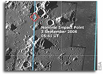
 This mosaic of images, obtained by the Advanced Moon Imaging Experiment (AMIE) on board ESA’s SMART-1 spacecraft, shows the SMART-1 landing site on the Moon. AMIE obtained this sequence on 19 August 2006 from the relatively high distance of 1200 kilometres from the surface (far from the SMART-1 perilune, or point of closer approach), with a ground resolution of about 120 metres per pixel. The imaged area, located at mid-southern latitudes on the lunar near-side, belongs to the so-called ‘Lake of Excellence’. To take these images, SMART-1 had to be tilted by 20 degrees in order to obtain a large ground coverage and an image mosaic of several views, each covering an area about 60 kilometres per side. More

Official website of the Lunar Orbiter Image Recovery Project (LOIRP)