
 On 23 August 1966, the Lunar Orbiter 1 spacecraft took a photo of the Earth as seen from lunar orbit. This image, albeit grainy, quickly became an icon of the Space Age. This “earthrise” photo, while spectacular at the time, was never retrieved and processed to the full level of detail contained in the image. This was due in great part of the available technology at the time. Computer image processing was in its infancy.
Forty two years later, the Lunar Orbiter Image Recovery Project (LOIRP) managed to retrieve the image from original data tapes using restored tape drives from the 1960s. In so doing the level of detail present in the image was unparalleled. Subsequently, other images have been retrieved with the ultimate goal of obtaining all of the images returned by the five Lunar Orbiters.
One of the striking aspects of this newly enhanced image is the amount of detail that can be seen on Earth at a resolution of perhaps 1 km/pixel taken from a quarter of a million miles away. Among the details visible is the extent of the southern polar ice cap.
The LOIRP required a lot of what has come to be called “techoarchaeology” that is, going back in time to the original data and recording devices, using modern enhancements. The expertise gained by the LOIRP team eventually caught the attention of the folks at the National Snow and Ice Data Center (NSIDC).
Data from the Nimbus weather and earth observation satellite – in orbit at the same time as the Lunar Orbiters were circling the Moon – had languished for years in the national archives until John Moses NASA Goddard Space Flight Center had them digitized.
Dr. Walt Meir of the National Snow and Ice Data Center, after seeing the work that the LOIRP team had done in potentially identifying the Antarctic sea ice in the Lunar Orbiter 1 Earthrise image, and recognizing the similarity between the raw data of the Nimbus and Lunar Orbiter data, provided a grant to the LOIRP team to process the Nimbus data into a modern format and to correct image artifacts that are common to both types of images.
The LOIRP team accomplished this, and rendered the images into the Google Earth format using a variety of internally developed techniques and elements of the NASA Ames developed NASA World Wind Java software development kit.
To date some of the images taken by Nimbus II have been enhanced and mapped into Google Earth. One date in particular was of interest to the LOIRP – 23 August 1966. As the images were enhanced and dropped into Google Earth it became clear that we have imagery that overlapped in time to show the weather on that late August day as evening crept up on Africa and Europe.
In New York City, just over the Earth’s limb as seen from lunar orbit, the Beatles were preparing to play at Shea Stadium …
You can download a KMZ file of these images here for viewing in Google Earth.
Related Links
– Techno-Archaeology Rescues Climate Data from Early Satellites
– LOIRP Aids In Finding Google Earth Images from 1966
– Newly Restored Lunar Orbiter Image of Earth and Moon (Detail)
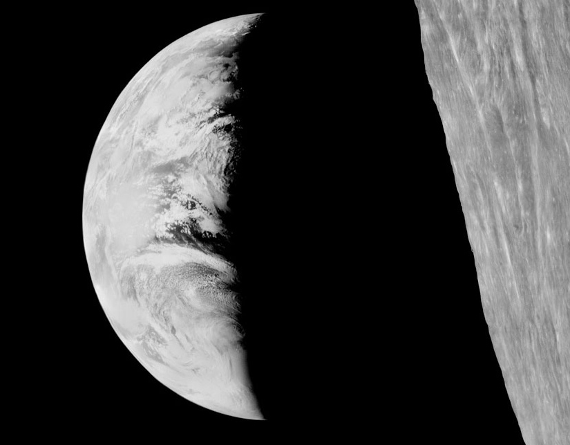
The original Lunar Orbiter 1 image of Earth on 23 August 1966 (click on image to enlarge)

Nimbus II imagery of Earth on 23 August 1966 (click on image to enlarge)

Overlap of Nimbus II imagery onto Lunar Orbiter 1 imagery (click on image to enlarge)
I really like this site and Nimbus II and Lunar Orbiter 1 Imagery: A New Look at Earth in 1966 (MoonViews – Providing Imagery and Data For Lunar Exploration) . I read about you on another site I found on Google and thought they had great views as well.