

This image, LO-IV-179-H1, taken by Lunar Orbiter IV on May 24, 1967 at 16:19:23.809 GMT, shows a portion of the lunar south polar region. A much larger version [1.8 MB JPG] can be downloaded here. You can download the full resolution image [692 MB tiff] here at NLSI.
The altitude of the spacecraft when this image was taken was 3,591.83 kilometers. The resolution of the image is 78.432 meters per pixel.
Spacecraft Position: Altitude: 3591.83 km, Latitude: -71.38°, Longitude: -96.22°
Principal Point: Latitude: -69.52°, Longitude: -74.07°
Illumination: Sun Azimuth: 68.15°, Incident Angle: 82.85°, Emission Angle: 11.24°, Phase Angle: 94.08°, Alpha: -11.23°

In addition to the Moon’s south pole (shaded), craters visible in this image include Drygalski, Cabeus (with its two satellite craters Cabeus A and Cabeus B), Malapert, Haworth, and Shoemaker.

This figure shows the region where this image was shot [red highlight]. Three high resolution frames were shot with this image covering the region over the south pole. [Larger image]
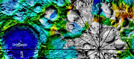
USGS map of the south pole showing the region covered in this Lunar Orbiter photo.

This collection of images of the lunar south pole shows the names of prominent features. Larger view.

“I have been involved in the illumination analysis of the lunar south pole for a while and your reference image (http://images.spaceref.com/news/2009/LO-IV-179-H1.label.jpg) seemed incorrect based on going over such images so many times. I checked it against Clementine imagery and it turns out that the labels you have are in the wrong places. I have attached a jpeg of the correct placements for the South Pole and Shackleton.” – James Fincannon, NASA GRC
I heard Shackleton crater is six miles deep, the deepest in the solar system.
is that true?
how could we utilize ice down there?
are there many other craters in other places that no sun ever shines into the bottom of?
No, Shackleton is not the deepest crater, even for the Moon. Based on Kaguya data, the bottom of the crater is at an elevation of -2.8 km. The highest point near/on its rim is +1.7 km (where a base would likely be located for power). The lowest “point” on the Moon using this dataset is inside Antoniadi crater (–172.58°E, 70.43°S, –9.06km) in the South Pole–Aitken Basin.
There are lots of lunar craters where direct Sunlight never shines. Some on Mercury too. Possible ice in these places.
Water ice would be gathered with machinery and melted/purified/electrolyzed for use possibly in fuel cells, human consumption or rocket fuel.