Comparing USGS and LOIRP Image Resolution

Several years ago the USGS Astrogeology Research Program began a project whereby copies of original Lunar Orbiter photos have been scanned using high resolution scanning devices. This graphic compares the calibration marks from a high resolution USGS scan and an inital image generated by the LOIRP. Larger image. Credit: NASA/USGS/LOIRP

Greater Surface Detail

This graphic compares the enhanced resolution of the LOIRP image and the highest resolution image available online at LPI. This image was taken on 23 August 1966 and restored by the Lunar Orbiter Image Recovery Project at NASA Ames Research Center. Larger image. Credit: NASA/LOIRP

Increase in Resolution

This graphic compares the enhanced resolution of the LOIRP image and the highest resolution image available online at LPI. Note the substantial increase in resolution with regard to the calibration marks at the bottom of this image. This image was taken on 23 August 1966 and restored by the Lunar Orbiter Image Recovery Project at NASA Ames Research Center. Larger image. Credit: NASA/LOIRP

NASA Unveils 42-Year-old Historic Lunar Image

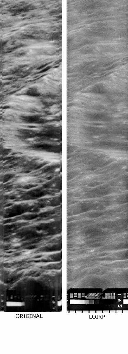
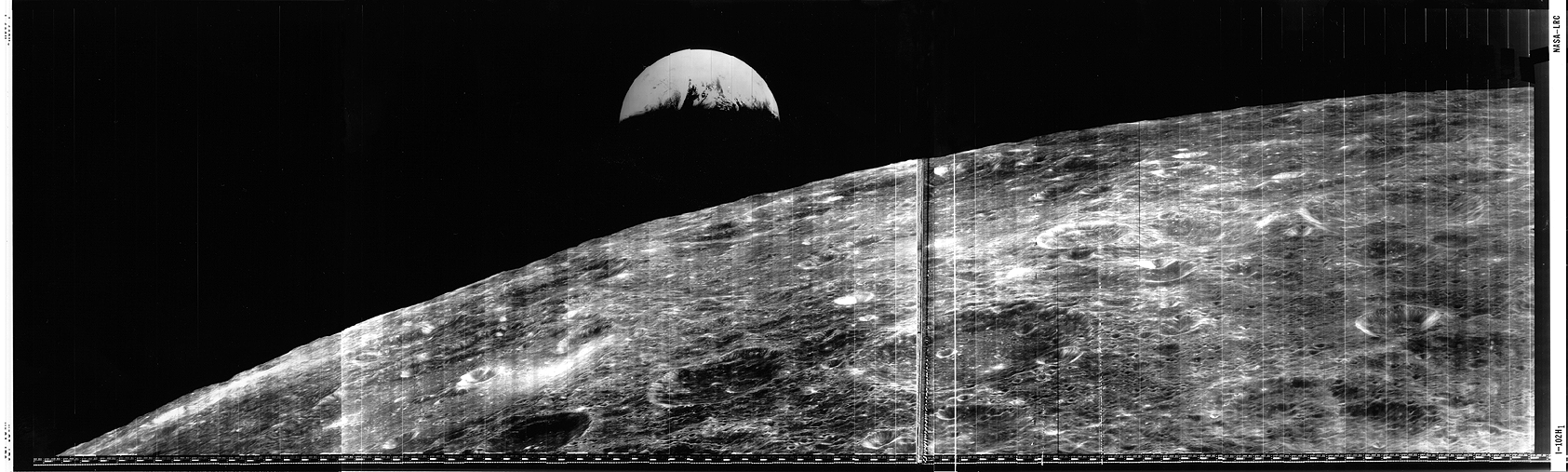
MOFFETT FIELD, Calif. – NASA will hold a media briefing at 3 p.m. PST on Thursday, Nov. 13, 2008, to unveil a newly restored historic image from the early days of lunar exploration and discuss the innovative processing technique used to retrieve the image.
The briefing will take place in the Ames Research Center auditorium, Bldg. N-201. NASA officials will be available to discuss the recovery process and the scientific value of the iconic images to the next generation of explorers as NASA plans to return to the moon. A tour of the restoration facility will be offered following the briefing.
Briefing participants are:
– S. Pete Worden, Ames Research Center Director
– Greg Schmidt, Deputy Director, NASA Lunar Science Institute, NASA Ames
– Dennis Wingo, Image Recovery Project Lead, Huntsville, Ala.
– Charles J. Byrne, Lunar Image Expert, Middletown, N.J.
For news media representatives unable to attend, a roundtable discussion will be held following the briefing. Reporters wanting to participate must call Mike Mewhinney at 650-604-3937 by Wednesday, Nov. 12, 2008.
Driving Directions: To reach NASA Ames, take the Moffett Field/NASA Parkway exit off U.S. 101 and drive east on Moffett Boulevard towards the main gate. At the main gate, pull into the small parking lot on your right and enter the Visitor Badge Office to obtain a visitor pass. The auditorium is located directly behind the administration building as you enter the center.
For more information about NASA Ames Research Center, visit:
http://www.nasa.gov/ames

‘Digital Dark Age’ may doom some data

‘Digital Dark Age’ may doom some data
10/27/08
Phil Ciciora, News Editor
217-333-2177;[email protected]
CHAMPAIGN, Ill. — What stands a better chance of surviving 50 years from now, a framed photograph or a 10-megabyte digital photo file on your computer’s hard drive?
The framed photograph will inevitably fade and yellow over time, but the digital photo file may be unreadable to future computers – an unintended consequence of our rapidly digitizing world that may ultimately lead to a “digital dark age,” says Jerome P. McDonough, assistant professor in the Graduate School of Library and Information Science at the University of Illinois at Urbana-Champaign.
According to McDonough, the issue of a looming digital dark age originates from the mass of data spawned by our ever-growing information economy – at last count, 369 exabytes worth of data, including electronic records, tax files, e-mail, music and photos, for starters. (An exabyte is 1 quintillion bytes; a quintillion is the number 1 followed by 18 zeroes.)
The concern for archivists and information scientists like McDonough is that, with ever-shifting platforms and file formats, much of the data we produce today could eventually fall into a black hole of inaccessibility.
“If we can’t keep today’s information alive for future generations,” McDonough said, “we will lose a lot of our culture.”
Contrary to popular belief, electronic data has proven to be much more ephemeral than books, journals or pieces of plastic art. After all, when was the last time you opened a WordPerfect file or tried to read an 8-inch floppy disk?
“Even over the course of 10 years, you can have a rapid enough evolution in the ways people store digital information and the programs they use to access it that file formats can fall out of date,” McDonough said.
Magnetic tape, which stores most of the world’s computer backups, can degrade within a decade. According to the National Archives Web site by the mid-1970s, only two machines could read the data from the 1960 U.S. Census: One was in Japan, the other in the Smithsonian Institution. Some of the data collected from NASA’s 1976 Viking landing on Mars is unreadable and lost forever.
From a cultural perspective, McDonough said there’s a “huge amount” of content that’s only being developed or is available in a digital-only format.
“E-mail is a classic example of that,” he said. “It runs both the modern business world and government. If that information is lost, you’ve lost the archive of what has actually happened in the modern world. We’ve seen a couple of examples of this so far.”
McDonough cited the missing White House e-mail archive from the run-up to the Iraq War, a violation of the Presidential Records Act.
“With the current state of the technology, data is vulnerable to both accidental and deliberate erasure,” he said. “What we would like to see is an environment where we can make sure that data does not die due to accidents, malicious intent or even benign neglect.”
McDonough also cited Barack Obama’s political advertising inside the latest editions of the popular videogames “Burnout Paradise” and “NBA Live” as an example of something that ought to be preserved for future generations but could possibly be lost because of the proprietary nature of videogames and videogame platforms.
“It’s not a matter of just preserving the game itself. There are whole parts of popular and political culture that we won’t be able to preserve if we can’t preserve what’s going on inside the gaming world.”
McDonough believes there would also be an economic effect to the loss of data from a digital dark age.
“We would essentially be burning money because we would lose the huge economic investment libraries and archives have made digitizing materials to make them accessible,” he said. “Governments are likewise investing huge sums to make documents available to the public in electronic form.”
To avoid a digital dark age, McDonough says that we need to figure out the best way to keep valuable data alive and accessible by using a multi-prong approach of migrating data to new formats, devising methods of getting old software to work on existing platforms, using open-source file formats and software, and creating data that’s “media-independent.”
“Reliance on open standards is certainly a huge part, but it’s not the only part,” he said. “If we want information to survive, we really need to avoid formats that depend on a particular media type. Commercial DVDs that employ protection schemes make it impossible for libraries to legally transfer the content to new media. When the old media dies, the information dies with it.”
Enthusiasm for switching from proprietary software such as Microsoft’s Office suite to open-source software such as OpenOffice has only recently begun to gather momentum outside of information technology circles.
“Software companies have seen the benefits of locking people into a platform and have been very resistant to change,” McDonough said. “Now we are actually starting to see some market mandates in the open direction.”
McDonough cites Brazil, the Netherlands and Norway as examples of countries that have mandated the use of non-proprietary file formats for government business.
“There has been quite a movement, particularly among governments, to say: ‘We’re not going to buy software that uses proprietary file formats exclusively. You’re going to have to provide an open format so we can escape from the platform,’ ” he said. “With that market demand, you really did see some more pressure on vendors to move to something open.”
Editor’s note: To contact Jerome McDonough, call 217-244-5916; e-mail [email protected]

Man’s First Look at Earth From the Moon….

NASA SP-168 EXPLORING SPACE WITH A CAMERA
ORBITER I
Describing the spectacular, historic view above, FLOYD L. THOMPSON, then Director, Langley Research Center, wrote: “At 16:35 GMT on August 23, 1966, the versatile manmade Lunar Orbiter spacecraft responded to a series of commands sent to it from Earth, across a quarter-million miles of space, and made this over-the-shoulder view of its home planet from a vantage point 730 miles above the far side of the Moon.
“At that moment,” Thompson continued, “the Sun was setting along an arc extending from England [on the right] to Antarctica [on the left]. Above that line, the world, with the east coast of the United States at the top, was still bathed in afternoon sunlight. Below, the major portion of the African Continent and the Indian Ocean were shrouded in the darkness of evening. “By this reversal of viewpoint, we here on the…
… and an Oblique View of the Moon Itself
….Earth have been provided a sobering glimpse of the spectacle of our own planet as it will be seen by a few of our generation in their pursuit of the manned exploration of space. We have achieved the ability to contemplate ourselves from afar and thus, in a measure, accomplish the wish expressed by Robert Burns: ‘To see oursels as ithers see us! ”
Also visible in dramatic new perspective in this photograph is the singularly bleak Iunar landscape, its tortured features evidently hammered out by a cosmic bombardment that may have extended over billions of years.
Because the airless, weatherless Moon appears to preserve its surface materials so well, it may serve science as an illuminating record of past events in the solar system. ROBERT JASTROW, Director Goddard Institute for Space Studies, has called the Moon “the Rosetta Stone of the planets.”

12 Oct 2008 LOIRP Status Earth/Moon Picture Decision

Destination Moon: A History of the Lunar Orbiter Program, NASA TM X-3487
Of all the pictures which Lunar Orbiter I made, one of the most spectacular was the first photograph of the Earth taken from the vicinity of the Moon. This picture was not included in the original mission plan, and it required that the spacecraft’s attitude in relation to the lunar surface be changed so that the camera’s lenses were pointing away from the Moon. Such maneuvering meant a calculated risk and, coming early in the flight, the unplanned photograph of Earth raised some doubts among Boeing management about the safety of the spacecraft.
Robert J. Helberg, Boeing’s Program Manager for Lunar Orbiter, opposed such a hazardous unnecessary risk. The spacecraft would be pointed away from the Moon so that [242] the camera’s lenses could catch a quick view of Earth tangential to the lunar surface. Then, once the pictures were made (flight controllers would execute two photo sequences on two different orbits), Lunar Orbiter I would disappear behind the Moon where it would not be in communication with ground control. If, for some reason ground control failed to reestablish communications with it, the Apollo-oriented mission photography would probably remain undone, Moreover, Boeing had an incentive riding on the performance of the spacecraft, and Heiberg did not think it prudent to commit the spacecraft to a series of maneuvers for which no plans had been made. 30
The understandably conservative Boeing stance was changed through a series of meetings between top NASA program officials, including Dr. Floyd L. Thompson, Clifford H. Nelson, and Lee R. Scherer. They convinced Heiberg that the picture was worth the risk and that NASA would make compensation in the event of an unexpected mishap with the spacecraft. After agreement had been reached, Lunar Orbiter flight controllers executed the necessary maneuvers to point the spacecraft’s camera away from the lunar surface, and on two different orbits (16 and 26) it recorded two unprecedented, very useful photographs.
[243] The Earth-Moon pictures proved valuable for their oblique perspective of the lunar surface. Until these two photographs, all pictures had been taken along axes perpendicular or nearly perpendicular to the Moon’s surface. On subsequent Lunar Orbiter missions oblique photography was planned and used more often. 31
30. Taback interview. See also Transcript of Proceedings–Discussion between Nicks, et al., and members of National Academy of Public Administration, pp. 111-112.
31. For a detailed technical description of the Earth-Moon photographs refer to Lunar Orbiter I Photography, NASA CR-847, prepared by Boeing Company, Seattle, Washington, for the Langley Research Center, August 1967, pp. 64-71.


The Orbital Period for LO-1 was 3 hrs 26 minutes and 21 seconds – that’s 34.3 hours between orbit 16 and 26 …. you could have had orbit 16 on 23 Aug and orbit 26 on 25 Aug …


1. If you listen to this audio [ http://images.spaceref.com/news/2008/loirptest5.mp3] from a data tape you will hear the technician state that it is an analog copy of an earlier tape – but that it is only a copy of the portion with the Earth and moon on it and that it was originally recorded on GMT date 237.
2. In 1966 day 237 was 25 August. Lunar Orbiter 1 was launched on 10 August 1966 and imaged the moon from 18-29 August 1966.
So, NASA NSSDC says that this image was taken on 23 August yet the tech’s voice says day 237 – this must be the date when the tape was being played back from the spacecraft to Earth, yes

6 Sep 2008 LOIRP Status

The first image you see here is the explanation from the original documentation showing what a single line of lunar orbiter video looks like.  The second, is the machine fully locked up and reproducing the correct structure.  The image is inverted as it gets flipped with a jumper select on the board that we just have another board that has the jumper but we weren’t using it.


If you look at the oscilloscope, you can see the fiducial marks in their proper position before and after the sync pulse.  If you look at the lower right part of the screen, you will see the notation (200us).  That is the amount of time per division.  If you count the divisions to the next sync pulse, you will see that it exactly matches the number for a single scan line below.  The voltage scale is correct as well except that the drawing below is wrong.  The signal is 1 volt, not five volts.  We have confirmation that 1 volt is the correct number from the audio tapes where the engineers recorded the voltage levels on the tape.  It is these kinds of discrepancies that we have had to research and overcome.  We have reached that magic milestone.  We now have to put those lines together into an image and we are working that now.  However, the two critical questions that were in everyones mind when we started this have been answered.  Are the tapes good?  Yes.  Can the drive be brought back to operational status? Yes.  
We are at a crossroads here and I will put together a formal report and seek input on where to go from here.  As a result of our work we have found a few things that were not in the documentation that effects which way we go forward from here.  Our original plan for digitizing the images is no longer tenable and we are doing a near term work around for the image milestone.

Keith Cowing: The Image we think we have – detective story

Keith Cowing: This is part of the detective work I used to help narrow down what image we may have found.
1. If you listen to this audio [ http://images.spaceref.com/news/2008/loirptest5.mp3] from a data tape you will hear the technician state that it is an analog copy of an earlier tape – but that it is only a copy of the portion with the Earth and moon on it and that it was originally recorded on GMT date 237.
2. In 1966 day 237 was 25 August. Lunar Orbiter 1 was launched on 10 August 1966 and imaged the moon from 18-29 August 1966.
3. This image of a page from a Lunar Orbiter planning document [ page 70 of Lunar Orbiter I – Photography NASA-CR-847 http://hdl.handle.net/2060/19670023005] clearly shows an image of the Earth from the moon being planed for Lunar Orbiter 1 on day 237.
http://images.spaceref.com/news/2008/day237.earth.moon.jpg
4. Apparently this was attempted more than once. Recall that Lunar Orbiter 1 was the first mission and they had a lot of bugs to work out with the imaging system.
5. According to http://nssdc.gsfc.nasa.gov/imgcat/html/object_page/lo1_h102_123.html Lunar Orbiter 1 took the first two remote images of earth from the distance of the Moon, August 23rd 1966.”
6. This is the series of three images stitched togetehr showing Earthrise above the lunar surface taken on 23 August 1966
http://images.spaceref.com/news/2008/lo1_h102_123.gif
Location & Time Information
Date/Time (UT): 1966-08-23 T 16:36:23
Distance/Range (km): 1476
Central Latitude/Longitude (deg): -14.68/104.34
Orbit(s): N/A
Imaging Information
Area or Feature Type: crater, global view
Instrument:  High-resolution Camera
Instrument Resolution (pixels): N/A
Instrument Field of View (deg): 20.4 x 5.16 
Filter: Clear
Illumination Incidence Angle (deg): 21.30
Phase Angle (deg): 95.07
Instrument Look Direction: N/A
Surface Emission Angle (deg): 80.94
Ordering Information
CD-ROM Volume: N/A
NASA Image ID number: L01-102; H1, H2, H3
Other Image ID number: N/A
NSSDC Data Set ID (Photo): 66-073Z-01D
NSSDC Data Set ID (CD): N/A
Other ID: N/A
7. Apparently there was some controversy about doing things like this with the spacecraft:
“Despite the malfunctions in the photographic subsystem the spacecraft succeeded in taking many historic pictures. Command and maneuver requirements were developed to take, [241] in near real-time, such pictures as those of the morning and evening terminator on the lunar surface, the Earth as seen from the Moon’s vicinity, numerous farside pictures, and additional photographs of sites of interest on the near side. Lunar Orbiter I photographed such areas as potential targets for Mission B, major craters, and mare and upland areas useful as Apollo navigation landmarks and was mostly able to satisfy the requirements to take these photographs.
Of all the pictures which Lunar Orbiter I made, one of the most spectacular was the first photograph of the Earth taken from the vicinity of the Moon. This picture was not included in the original mission plan, and it required that the spacecraft’s attitude in relation to the lunar surface be changed so that the camera’s lenses were pointing away from the Moon. Such maneuvering meant a calculated risk and, coming early in the flight, the unplanned photograph of Earth raised some doubts among Boeing management about the safety of the spacecraft.
Robert J. Helberg, Boeing’s Program Manager for Lunar Orbiter, opposed such a hazardous unnecessary risk. The spacecraft would be pointed away from the Moon so that [242] the camera’s lenses could catch a quick view of Earth tangential to the lunar surface. Then, once the pictures were made (flight controllers would execute two photo sequences on two different orbits), Lunar Orbiter I would disappear behind the Moon where it would not be in communication with ground control. If, for some reason ground control failed to reestablish communications with it, the Apollo-oriented mission photography would probably remain undone, Moreover, Boeing had an incentive riding on the performance of the spacecraft, and Heiberg did not think it prudent to commit the spacecraft to a series of maneuvers for which no plans had been made.30
The understandably conservative Boeing stance was changed through a series of meetings between top NASA program officials, including Dr. Floyd L. Thompson, Clifford H. Nelson, and Lee R. Scherer. They convinced Heiberg that the picture was worth the risk and that NASA would make compensation in the event of an unexpected mishap with the spacecraft. After agreement had been reached, Lunar Orbiter flight controllers executed the necessary maneuvers to point the spacecraft’s camera away from the lunar surface, and on two different orbits (16 and 26) it recorded two unprecedented, very useful photographs.
[243] The Earth-Moon pictures proved valuable for their oblique perspective of the lunar surface. Until these two photographs, all pictures had been taken along axes perpendicular or nearly perpendicular to the Moon’s surface. On subsequent Lunar Orbiter missions oblique photography was planned and used more often.31”
8. We know that we have an image on this particular tape.