
 Volunteers Needed to Preserve Astronomical History and Promote Discovery
“Digitizing the ~500,000 glass plate images covering the full sky will foster new scientific discoveries for the currently ‘hot’ field of studying variability of astronomical objects, or time domain astronomy, as we bring to light these long-hidden archives,” says Harvard professor Josh Grindlay, the leader of the Digital Access to a Sky Century at Harvard (DASCH) project. The telescope logbooks record vital information associated with a 100-year-long effort to record images of the sky. By transcribing logbook text to put those historical observations in context, volunteers can help to unlock hidden discoveries.”
Technoarchaeology and Nimbus Weather Data
NIMBUS: Recovering the Past
 Dumpster Diving for Science
“Last month, researchers working out of an abandoned McDonald’s restaurant on the grounds of NASA Ames Research Center recovered data collected by NASA’s Nimbus II satellite on 23 September 1966. The satellite soared over Earth in a polar orbit every 108 minutes, taking pictures of cloud cover and measuring heat radiated from the planet’s surface, and creating a photo mosaic of the globe 43 years ago. The resulting image is the oldest and most detailed from NASA’s Earth-observing satellites. It’s also the latest success story in what researchers call techno-archaeology: pulling data from archaic storage systems. Once forgotten and largely unreadable with modern equipment, old data tapes are providing researchers with new information on changes in the surfaces of Earth and the moon…”
 Nimbus II and Lunar Orbiter 1 Imagery: A New Look at Earth in 1966
“The LOIRP required a lot of what has come to be called “techoarchaeology” that is, going back in time to the original data and recording devices, using modern enhancements. The expertise gained by the LOIRP team eventually caught the attention of the folks at the National Snow and Ice Data Center (NSIDC). Data from the Nimbus weather and earth observation satellite – in orbit at the same time as the Lunar Orbiters were circling the Moon – had languished for years in the national archives until John Moses NASA Goddard Space Flight Center had them digitized. Dr. Walt Meir of the National Snow and Ice Data Center, after seeing the work that the LOIRP team had done in potentially identifying the Antarctic sea ice in the Lunar Orbiter 1 Earthrise image, and recognizing the similarity between the raw data of the Nimbus and Lunar Orbiter data, provided a grant to the LOIRP team to process the Nimbus data into a modern format and to correct image artifacts that are common to both types of images. The LOIRP team accomplished this, and rendered the images into the Google Earth format using a variety of internally developed techniques and elements of the NASA Ames developed NASA World Wind Java software development kit.”
Techno-archaeology rescues climate data from early satellites, NSDIC
“Starting with the methods developed for the Lunar Orbiter Image Recovery Project (LOIRP) at NASA Ames Research Park, a team at NSIDC worked with Dennis Wingo at LOIRP to search NASA archives for the original Nimbus tapes containing raw images and calibrations. Their first goal was to read and reprocess the data at a higher resolution, removing errors resulting from the limits of the original processing.”
LOIRP Aids In Finding Google Earth Images from 1966
“After determining that it was highly unlikely that any of the early Nimbus 2″ analog tapes still existed we began our work to rectify some of the image artifacts in the Nimbus II HRIR data files. The data that we were working with is remarkably similar to the Lunar Orbiter raw analog data, but this is two generations removed from the raw data, the sync pulses and the calibration data had been removed. This was probably in order to save tape back in the 1960’s. The surviving original data today is of fairly poor quality.”
Technoarchaeology: Nimbus and LOIRP
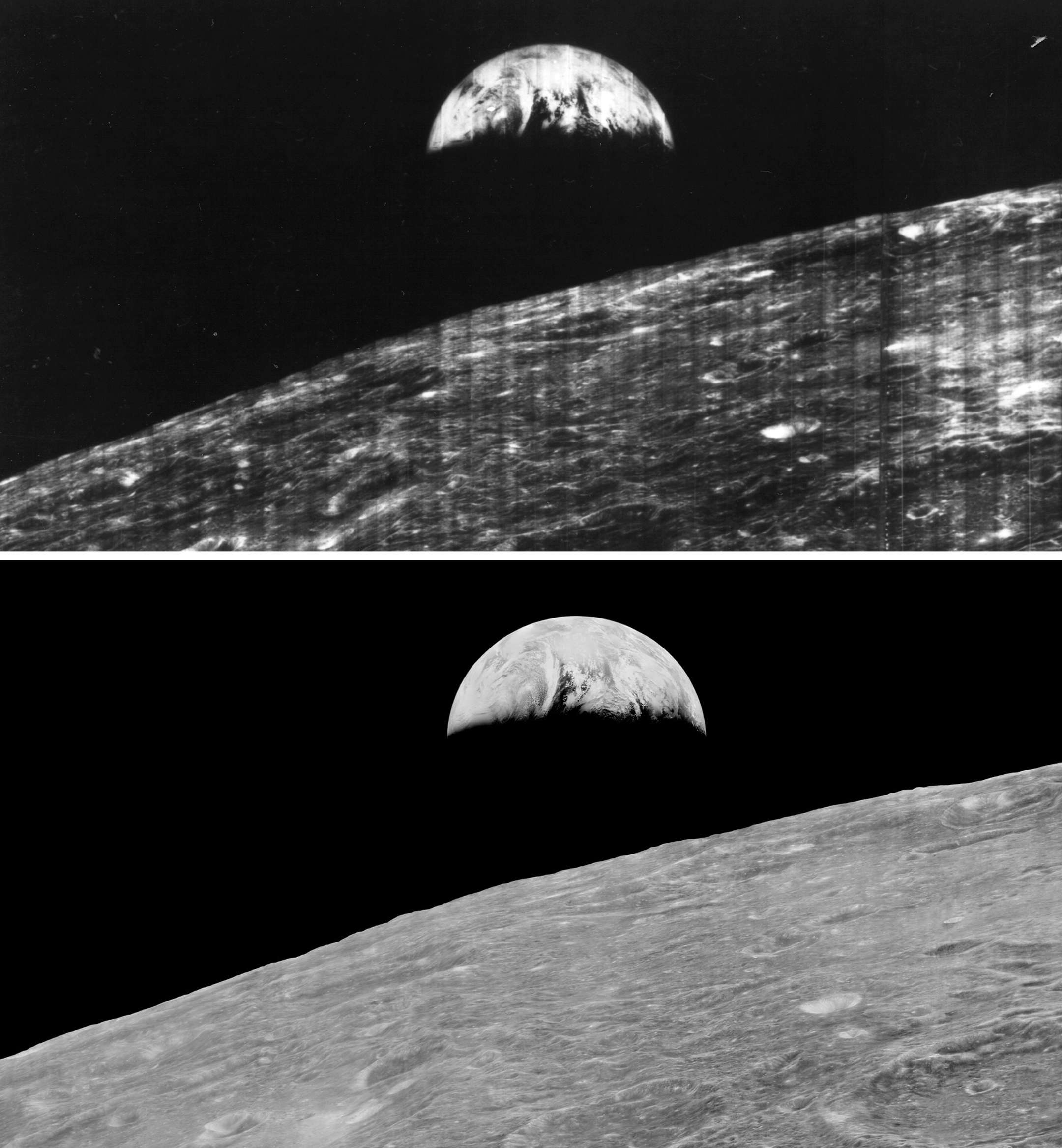
First Earthrise Photo Taken 48 Years Ago Today

![]() Keith’s note: 48 Years ago today, on 23 August 1966, Lunar Orbiter 1 snapped the first photo of Earth as seen from lunar orbit (Larger view). While a remarkable image at the time, the full resolution of the image was never retrieved from the data stored from the mission. In 2008, this earthrise image was restored by the Lunar Orbiter Image Recovery Project at NASA Ames Research Center. We obtained the original data tapes from the mission (the last surviving set) and restored original FR-900 tape drives to operational condition using both 60s era parts and modern electronics. The following links provide background on the image, its restoration, and reactions to its release.
Keith’s note: 48 Years ago today, on 23 August 1966, Lunar Orbiter 1 snapped the first photo of Earth as seen from lunar orbit (Larger view). While a remarkable image at the time, the full resolution of the image was never retrieved from the data stored from the mission. In 2008, this earthrise image was restored by the Lunar Orbiter Image Recovery Project at NASA Ames Research Center. We obtained the original data tapes from the mission (the last surviving set) and restored original FR-900 tape drives to operational condition using both 60s era parts and modern electronics. The following links provide background on the image, its restoration, and reactions to its release.
Here is a comparison of the full image in its original, familiar context (higher res)(print quality). You can download a 1.2 GB version from NASA here. Note: this is a very large file.

– Newly Restored Lunar Orbiter Image of Earth and Moon (Detail)
– How the Photo Was Taken
– House of Representatives Honors Lunar Orbiter Image Recovery Project
– Nimbus II and Lunar Orbiter 1 Imagery: A New Look at Earth in 1966
– Dumpster Diving for Science, Science Magazine
– What Lunar Orbiter 1 Was Seeing on 23 August 1966
More Visitors to McMoons
Loral Interns visited McMoons today for a tour of the Lunar Orbiter Image Recovery Project and #ISEE3 Reboot Project. pic.twitter.com/X6WOchuWf2
— LunarOrbiter (@LunarOrbiter) August 8, 2014
Lunar Orbiter V View of the Whole Earth
Lunar Orbiter V Image of "Full Earth" taken on 8 Aug 1967 http://t.co/yUi5GZfHm5 pic.twitter.com/pafGt82jJa
— LunarOrbiter (@LunarOrbiter) August 8, 2014
Video: 50 year old NASA pictures in a whole new light
50 year old NASA pictures in a whole new light, NewsFix
“In the 60’s, lunar orbiters took thousands of pictures from space, but few ever saw the originals. “They took their pictures on film and they developed them in their own little darkroom and they scanned them like an old wire photo and the signal came back to earth and they showed it on a tv screen, they then took a picture of the tv screen and printed out those pictures and took pictures of the pictures.” Explained Keith Cowing of the Lunar Orbiter Image Recovery Project Needless to say, the quality of the pictures got worse and worse.”
LOIRP Featured on CNN
"No human eye had ever seen this." Here's your peek at @NASA's lost lunar photos: http://t.co/4GZVbdzuSZ pic.twitter.com/Uiv4TBqry1
— CNN (@CNN) July 30, 2014
More Visitors to McMoons
Thanks! Dennis Wingo for @spacedotcom's @ISEE3Reboot tour @ #McMoons 2 day @NASAAmes @michaeldwall @KeithCowing pic.twitter.com/K3i3fIgmmL
— Tariq J. Malik (@tariqjmalik) July 30, 2014
Visitors to McMoons
Visited "McMoons" yesterday. A haven of innovative & inspirational space magic for @ISEE3Reboot & @LunarOrbiter pic.twitter.com/5DhPJQhbyX
— James (@star_avi8r) July 25, 2014
@KeithCowing @LunarOrbiter & @ISEE3Reboot raising the bar for citizen science from abandoned McDonalds at @NASAAmes pic.twitter.com/BeDTh8MmD1
— CSF Spaceflight (@csf_spaceflight) July 24, 2014
Education and Public Outreach: Lunar Orbiter and ISEE-3
 This poster presentation by Keith Cowing and Dennis Wingo was produced for the NASA SSERVI Exploration Science Forum 21-23 July 2014. Click on image for full poster (PDF)
Introduction
Any space mission worth doing should have an education and public outreach (EPO) component. An EPO effort helps to efficiently disseminate information to those with a specific interest in a particular mission. Done properly it also serves as a means to spur interest in space exploration in general amongst a much broader audience. With the use of various Internet and social media resources an effective EPO effort can now reach an audience in ways that were not possible a decade ago.
Continue reading “Education and Public Outreach: Lunar Orbiter and ISEE-3”
Lunar Orbiter Image Recovery Project Documentary by Carnegie Museum of Art is Now Online
In Part 3 of The Invisible Photograph, see how the “techno archaeologists” of the Lunar Orbiter Image Recovery Project digitally recovered the first photographs of the moon taken by a set of unmanned space probes in the 1960s. More information and Gigapan imagery.
Would-Be Rescuers of Wayward Spacecraft Previously Solved a NASA Mystery, New York Times
“Before reviving a zombie spacecraft, Dennis Wingo and Keith Cowing traveled to the past to rescue a trove of early moon photographs that otherwise would have been destined for oblivion. They did not actually time travel, but that might have been easier. Mr. Wingo, an entrepreneur and an engineer, and Mr. Cowing, the editor in chief of the NASA Watch website, had confidence that they could decipher decades-obsolete NASA equipment, because, as Mr. Cowing said, “we’ve done this before.” … The earlier project involved 1,500 magnetic tapes and a couple of old, broken tape drives. In 1966 and 1967, NASA sent five robotic spacecraft, the Lunar Orbiters, to photograph the moon’s surface to help find safe landing sites for the Apollo astronauts. The tapes, which recorded the original high-resolution images, and the tape drives ended up in the garage of a former NASA employee, and Mr. Wingo and Mr. Cowing embarked on a quixotic mission to retrieve the images.”
LOIRP Film Premieres at Carnegie Museum of Art
|
|