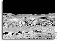
This newly retrieved medium resolution image, frame 2011_M, was taken by Lunar Orbiter 2 on 18 November 1966 at 15:25 GMT LPI reference. Images: [large at LOIRP] [Very Large at NASA NLSI]

This newly retrieved medium resolution image, frame 2011_M, was taken by Lunar Orbiter 2 on 18 November 1966 at 15:25 GMT LPI reference. Images: [large at LOIRP] [Very Large at NASA NLSI]

Today an iconic image from the initial exploration of the Moon is being re-released showing detail that could not have been seen using technology available at the time the photo was taken. This image features a dramatic view inside the majestic crater Copernicus – a view that left millions in awe when it was first released.
This image was announced at the First Global Space Exploration Conference, co-sponsored by the AIAA and IAF, in Washington, DC.
Between 1966 and 1967 NASA sent five Lunar Orbiter spacecraft to the Moon. Their job was to survey the surface to help determine landing sites for the upcoming Apollo missions. In addition to their recon role, these spacecraft also contributed to the nascent scientific understanding of the Moon. But every once in a while these spacecraft also served as artists, snapping photos of this nearby world in a way that human eyes had never been able to see before.
Once such image was taken of crater Copernicus on 24 November 1966 by the Lunar Orbiter 2 spacecraft. What made this photo so unique was the oblique angle it was taken at as well the close proximity of the spacecraft to its target. The image was taken at an altitude of 45 km (27.1 miles) at a distance of approximately 207.7 km (~125 miles) from the center of the crater. Instead of looking down, the spacecraft looked sideways at the Moon.
For the first time people saw the Moon as a world with mountains and boulders and other features (some of them strange) that were not apparent from photos where the view was looking straight down. So taken were people at the time that Life Magazine took to calling the photo “The Picture of the Century”. Along with the equally famous Earthrise image taken by Lunar Orbiter 1, the Moon went from being a distant sight in the sky to a world waiting to be explored – in person.

At the time that the images were taken using film that was actually developed aboard the spacecraft in lunar orbit, the ability to send back imagery was nothing like it is today. The photos were scanned much like news photos of the day and the data was sent back to Earth. The images were then printed out on photo graphic paper and used to construct maps of the lunar surface. In so doing a lot of data from the original photos was lost. Luckily NASA had the foresight to listen to the suggestions of project engineers such as Charles Byrne and stored the original data on analog tapes.
Some 40 years after these missions were completed the Lunar Orbiter Image Recovery Project (LOIRP) was begun with the intent of using refurbished tape drives and a complete set of original project tapes (over 1,500). Utilizing funding from NASA, facilities offered by NASA Ames Research Center, and donated effort and resources from SkyCorp Inc. and SpaceRef Interactive Inc., the LOIRP team was able to return the original drives to operation such that the data on the tapes could be accessed.
By adding modern computer interfaces and data handling techniques, the LOIRP was able to scan and record the data in ways that simply could not have been accomplished in the 1960s. As a result the images that were obtained had a much higher resolution and dynamic range than had been seen to date. Indeed, in many cases, these images often rival or exceed images taken by the Lunar Reconnaissance Orbiter which is currently surveying the Moon.
In 2009 LOIRP released its first attempt to retrieve this image of Copernicus. In the ensuing several years the process of calibrating thee tape drives, scanning the tapes, and assembling and processing the imagery has improved to the point that a new attempt to retrieve the image was undertaken.
This project is multi-generational in many ways. The tape drives use original parts and modern components and are connected to monitoring equipment that is itself decades old. All of this is connected to Mac desktop computers running of the shelf software. There are some special tools. Some of the software LOIRP now uses to process these images was written by Charles Byrne – the very same person who suggested that these images be stored on data tapes over 40 years ago.
LOIRP also involves the participation of young people such as Austin Epps and Neulyn Moss in the process of generating and analyzing the images. LOIRP also has a regular series of local students working as interns to assist the project.
It is important to remember that as we look toward the Moon, Mars and other places as future destinations that we are not the first generation to do so. In the 1960s people had the same dreams – and they acted upon them with simpler tools than we have today. There is a lot to be gained from talking to people from that era. They have more than just memories of these days. Unlike many of us today, they know how to actually make their dreams become reality. That advice is timeless and is something that needs to be passed on to a new generation. We take it very seriously at LOIRP. Indeed, had we not done so, we’d never have retrieved these images.
About LOIRP
The Lunar Orbiter Image Recovery Project (LOIRP) is located at the NASA Research Park at Moffett Field, CA. Funding and support for this project has been provided by the NASA Human Exploration Operations Mission Directorate, the NASA Innovative Partnerships Program, the NASA Lunar Science Institute, NASA Ames Research Center, SkyCorp Inc., and SpaceRef Interactive Inc.
For more information on the Lunar Orbiter Image Recovery Project (LOIRP) visit https://moonviews.wpenginepowered.com
For information on NASA’s Lunar Science Institute visit http://lunarscience.arc.nasa.gov/
IMAGES

Image: This is the newly reprocessed view of Copernicus. (larger image) (Raw image 683.2MB LINK NOT WORKING) Credit: LOIRP

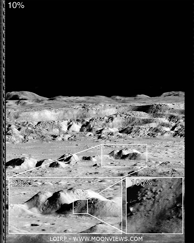
Image: This image shows the magification that is possible with the LOIRP image recovery process (larger image) Credit: LOIRP

Image: If you take the highest resolution image that is available on the LPI Lunar Orbiter site and compare it with the new LOIRP image, the increase in size becomes obvious. Credit: LOIRP

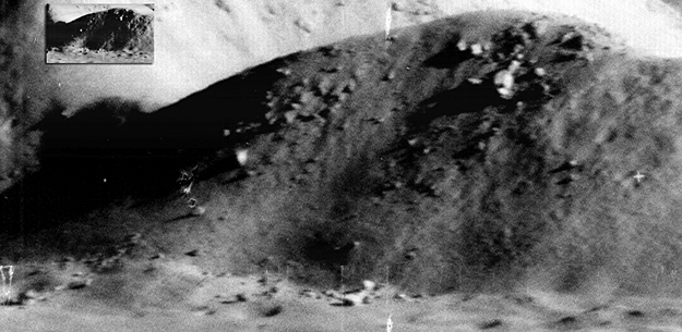
Image: The amount of detail that the new image reveals is clear. Not only is the resolution much higher, but the dynamic range is greater so as to allow gradations in surface texture, shadows, etc. to be much more clearly pronounced (larger image). Credit: LOIRP

An odd-looking impact feature raises an intriguing, Apollo-era trivia question (3.02°S, 119.15°E). NAC image number M141485413; incidence angle 12°; Sun is from the east; north is up; image is ~600 meters across [NASA/GSFC/Arizona State University].
Lunar Orbiter 2 was an unmanned imaging spacecraft used in November and early December 1966 to aid with Apollo and Surveyor landing site selection. The spacecraft became famous in 1967 with the public release of an oblique image of Copernicus crater (one of only four obliques collected), which was hailed as the “Picture of the Century” by the news media of the day. According to the 2007 International Atlas of Lunar Exploration, the Lunar Orbiter 2 spacecraft was commanded to crash into the lunar farside surface on October 11, 1967.
The coordinates of the Lunar Orbiter 2 impact are given as 119.1° east longitude and 3.0° north latitude, which match those of the feature in the NAC image (measured at 119.149° east longitude, and 3.020° north latitude). However, the published Lunar Orbiter 2 numbers are given as a rough estimate because the impact occurred on the farside of the Moon, out of direct radio contact. So the match with the NAC coordinates could be a coincidence.
The impact appears much too large (~85 m in diameter) to be the result of an impact from a spacecraft only a few meters tall, but with a solar incidence angle of only 12 degrees, it is difficult to see the crater rim and find out the true diameter. Perhaps the ejecta pattern extends far beyond the immediate impact. The truth is that we are not sure what caused this impact feature. We are currently re-targeting the area under a higher incidence angle to help with crater rim measurements. Stay tuned!
More

This newly retrieved high resolution image, frame 2046_H2, was taken by Lunar Orbiter 2 on 19 November 1966 at 15:44:28 GMT LPI reference Images: [large] [Very Large]

This newly retrieved high resolution image, frame 2199_H3, was taken by Lunar Orbiter 2 on 25 November 1966 at 07:21:17 GMT LPI reference Images: [large] [Very Large]

This newly retrieved high resolution image, frame 2198_M, was taken by Lunar Orbiter 2 on 25 November 1966 at 07:21:15 GMT LPI reference Images: [large] [Very Large]

This newly retrieved high resolution image, frame 2197_H3, was taken by Lunar Orbiter 2 on 25 November 1966 at 07:21:13 GMT LPI reference Images: [large] [Very Large]

This newly retrieved high resolution image, frame 2195_H2, was taken by Lunar Orbiter 2 on 25 November 1966 at 00:22:55 GMT LPI reference Images: [large] [Very Large]

This newly retrieved high resolution image, frame 2195_H1, was taken by Lunar Orbiter 2 on 25 November 1966 at 00:22:55 GMT LPI reference Images: [large] [Very Large]

This newly retrieved high resolution image, frame 2177_H3, was taken by Lunar Orbiter 2 on 24 November 1966 at 10:33:09 GMT LPI reference Images: [large] [Very Large]

This newly retrieved high resolution image, frame 2177_H1, was taken by Lunar Orbiter 2 on 24 November 1966 at 10:33:09 GMT LPI reference Images: [large] [Very Large]

This medium resolution image, frame 2011_M, was taken by Lunar Orbiter 2 on 18 November 1966 at 15:25:05 GMT LPI reference Images: [Large] [Very Large]