

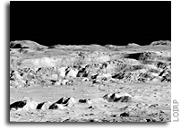
Today an iconic image from the initial exploration of the Moon is being re-released showing detail that could not have been seen using technology available at the time the photo was taken. This image features a dramatic view inside the majestic crater Copernicus – a view that left millions in awe when it was first released.
This image was announced at the First Global Space Exploration Conference, co-sponsored by the AIAA and IAF, in Washington, DC.
Between 1966 and 1967 NASA sent five Lunar Orbiter spacecraft to the Moon. Their job was to survey the surface to help determine landing sites for the upcoming Apollo missions. In addition to their recon role, these spacecraft also contributed to the nascent scientific understanding of the Moon. But every once in a while these spacecraft also served as artists, snapping photos of this nearby world in a way that human eyes had never been able to see before.
Once such image was taken of crater Copernicus on 24 November 1966 by the Lunar Orbiter 2 spacecraft. What made this photo so unique was the oblique angle it was taken at as well the close proximity of the spacecraft to its target. The image was taken at an altitude of 45 km (27.1 miles) at a distance of approximately 207.7 km (~125 miles) from the center of the crater. Instead of looking down, the spacecraft looked sideways at the Moon.
For the first time people saw the Moon as a world with mountains and boulders and other features (some of them strange) that were not apparent from photos where the view was looking straight down. So taken were people at the time that Life Magazine took to calling the photo “The Picture of the Century”. Along with the equally famous Earthrise image taken by Lunar Orbiter 1, the Moon went from being a distant sight in the sky to a world waiting to be explored – in person.
At the time that the images were taken using film that was actually developed aboard the spacecraft in lunar orbit, the ability to send back imagery was nothing like it is today. The photos were scanned much like news photos of the day and the data was sent back to Earth. The images were then printed out on photo graphic paper and used to construct maps of the lunar surface. In so doing a lot of data from the original photos was lost. Luckily NASA had the foresight to listen to the suggestions of project engineers such as Charles Byrne and stored the original data on analog tapes.
Some 40 years after these missions were completed the Lunar Orbiter Image Recovery Project (LOIRP) was begun with the intent of using refurbished tape drives and a complete set of original project tapes (over 1,500). Utilizing funding from NASA, facilities offered by NASA Ames Research Center, and donated effort and resources from SkyCorp Inc. and SpaceRef Interactive Inc., the LOIRP team was able to return the original drives to operation such that the data on the tapes could be accessed.
By adding modern computer interfaces and data handling techniques, the LOIRP was able to scan and record the data in ways that simply could not have been accomplished in the 1960s. As a result the images that were obtained had a much higher resolution and dynamic range than had been seen to date. Indeed, in many cases, these images often rival or exceed images taken by the Lunar Reconnaissance Orbiter which is currently surveying the Moon.
In 2009 LOIRP released its first attempt to retrieve this image of Copernicus. In the ensuing several years the process of calibrating thee tape drives, scanning the tapes, and assembling and processing the imagery has improved to the point that a new attempt to retrieve the image was undertaken.
This project is multi-generational in many ways. The tape drives use original parts and modern components and are connected to monitoring equipment that is itself decades old. All of this is connected to Mac desktop computers running of the shelf software. There are some special tools. Some of the software LOIRP now uses to process these images was written by Charles Byrne – the very same person who suggested that these images be stored on data tapes over 40 years ago.
LOIRP also involves the participation of young people such as Austin Epps and Neulyn Moss in the process of generating and analyzing the images. LOIRP also has a regular series of local students working as interns to assist the project.
It is important to remember that as we look toward the Moon, Mars and other places as future destinations that we are not the first generation to do so. In the 1960s people had the same dreams – and they acted upon them with simpler tools than we have today. There is a lot to be gained from talking to people from that era. They have more than just memories of these days. Unlike many of us today, they know how to actually make their dreams become reality. That advice is timeless and is something that needs to be passed on to a new generation. We take it very seriously at LOIRP. Indeed, had we not done so, we’d never have retrieved these images.
About LOIRP
The Lunar Orbiter Image Recovery Project (LOIRP) is located at the NASA Research Park at Moffett Field, CA. Funding and support for this project has been provided by the NASA Human Exploration Operations Mission Directorate, the NASA Innovative Partnerships Program, the NASA Lunar Science Institute, NASA Ames Research Center, SkyCorp Inc., and SpaceRef Interactive Inc.
For more information on the Lunar Orbiter Image Recovery Project (LOIRP) visit https://moonviews.wpenginepowered.com
For information on NASA’s Lunar Science Institute visit http://lunarscience.arc.nasa.gov/
IMAGES

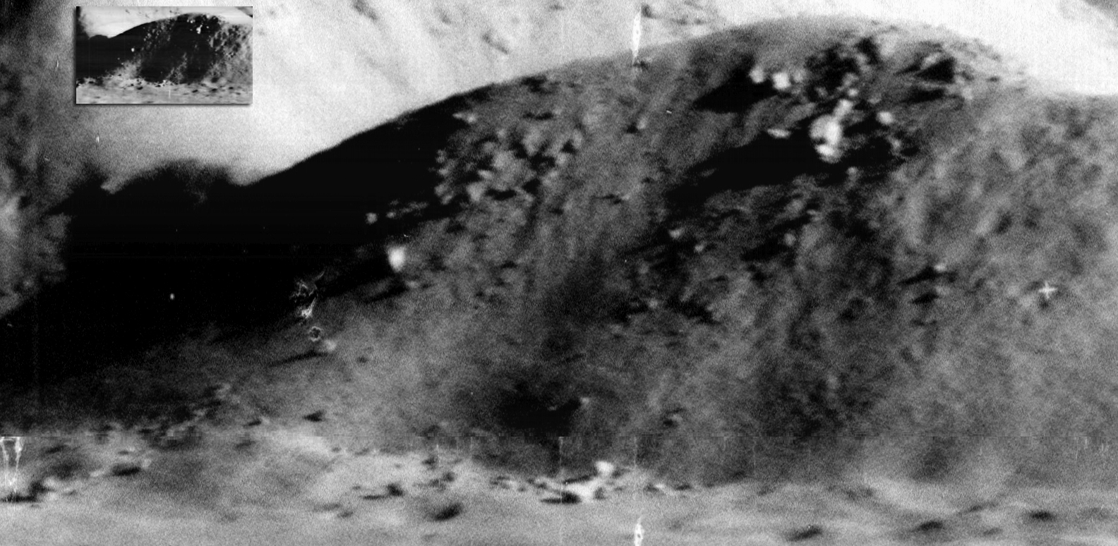
Image: This is the newly reprocessed view of Copernicus. (larger image) (Raw image 683.2MB LINK NOT WORKING) Credit: LOIRP
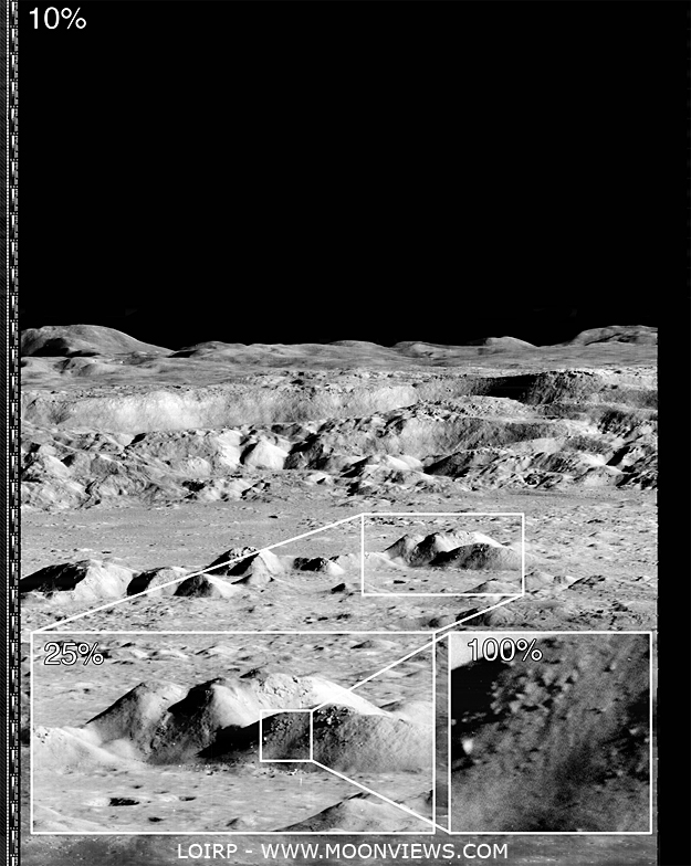
Image: This image shows the magification that is possible with the LOIRP image recovery process (larger image) Credit: LOIRP

Image: If you take the highest resolution image that is available on the LPI Lunar Orbiter site and compare it with the new LOIRP image, the increase in size becomes obvious. Credit: LOIRP

Image: The amount of detail that the new image reveals is clear. Not only is the resolution much higher, but the dynamic range is greater so as to allow gradations in surface texture, shadows, etc. to be much more clearly pronounced (larger image). Credit: LOIRP
Technoarchaeology: Restored Gemini Program Photos

Source, Gemini VII.
Restored Photos: Project Gemini Comes to Life
“On 23 March 1965, the first of ten crewed Gemini spacecraft was launched carrying it’s crew of two astronauts, Gus Grissom and John Young. The NASA Johnson Space Center and the School of Earth and Space Exploration at Arizona State University today proudly unveil the Project Gemini Online Digital Archive. The archive contains the first high-resolution digital scans of the original Gemini flight films, now available in several formats with a click of your mouse.”
Powerful Pixels: Mapping the Apollo Zone on the Moon
Mosaic of the near side of the moon as taken by the Clementine star trackers. The images were taken on March 15, 1994. Credit: NASA
Grayscale pixels – up close, they look like black, white or grey squares. But when you zoom out to see the bigger picture, they can create a digital photograph, like this one of our moon: For NASA researchers, pixels are much more – they are precious data that help us understand where we came from, where we’ve been, and where we’re going.
At NASA’s Ames Research Center, Moffett Field, Calif., computer scientists have made a giant leap forward to pull as much information from imperfect static images as possible. With their advancement in image processing algorithms, the legacy data from the Apollo Metric Camera onboard Apollo 15, 16 and 17 can be transformed into an informative and immersive 3D mosaic map of a large and scientifically interesting part of the moon.
The “Apollo Zone” Digital Image Mosaic (DIM) and Digital Terrain Model (DTM) maps cover about 18 percent of the lunar surface at a resolution of 98 feet (30 meters) per pixel. The maps are the result of three years of work by the Intelligent Robotics Group (IRG) at NASA Ames, and are available to view through the NASA Lunar Mapping and Modeling Portal (LMMP) and Google Moon feature in Google Earth.
“The main challenge of the Apollo Zone project was that we had very old data – scans, not captured in digital format,” said Ara Nefian, a senior scientist with the IRG and Carnegie Mellon University-Silicon Valley. “They were taken with the technology we had over 40 years ago with imprecise camera positions, orientations and exposure time by today’s standards.”
The researchers overcame the challenge by developing new computer vision algorithms to automatically generate the 2D and 3D maps. Algorithms are sets of computer code that create a procedure for how to handle certain set processes. For example, part of the 2D imaging algorithms align many images taken from various positions with various exposure times into one seamless image mosaic. In the mosaic, areas in shadows, which show up as patches of dark or black pixels are automatically replaced by lighter gray pixels. These show more well-lit detail from other images of the same area to create a more detailed map.

Left: A normal one-camera image of the lunar surface. Right: A composite Apollo Zone image showing the best details from multiple photographs. Credit: NASA/Google Earth
“The key innovation that we made was to create a fully automatic image mosaicking and terrain modeling software system for orbital imagery,” said Terry Fong, director of IRG. “We have since released this software in several open-source libraries including Ames Stereo Pipeline, Neo-Geography Toolkit and NASA Vision Workbench.”
Lunar imagery of varying coverage and resolution has been released for general use for some time. In 2009, the IRG helped Google develop “Moon in Google Earth”, an interactive, 3D atlas of the moon. With “Moon in Google Earth”, users can explore a virtual moonscape, including imagery captured by the Apollo, Clementine and Lunar Orbiter missions.
The Apollo Zone project uses imagery recently scanned at NASA’s Johnson Space Center in Houston, Texas, by a team from Arizona State University. The source images themselves are large – 20,000 pixels by 20,000 pixels, and the IRG aligned and processed more than 4,000 of them. To process the maps, they used Ames’ Pleiades supercomputer.
The initial goal of the project was to build large-scale image mosaics and terrain maps to support future lunar exploration. However, the project’s progress will have long-lasting technological impacts on many targets of future exploration.
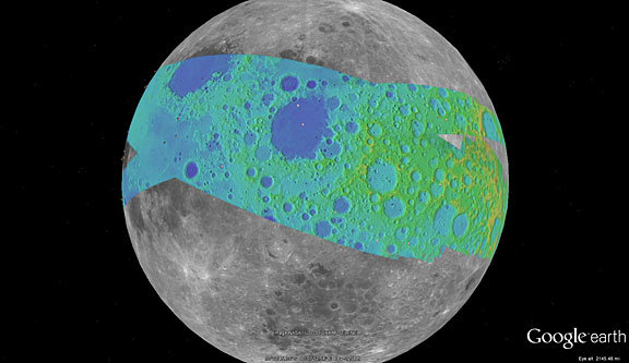
The color on this map represents the terrain elevation in the Apollo Zone mapped area. Credit: NASA/Google Earth
“The algorithms are very complex, so they don’t yet necessarily apply to things like real time robotics, but they are extremely precise and accurate,” said Nefian. “It’s a robust technological solution to deal with insufficient data, and qualities like this make it superb for future exploration, such as a reconnaissance or mapping mission to a Near Earth Object.”
Near Earth Objects, or “NEOs” are comets and asteroids that have been attracted by the gravity of nearby planets into orbits in Earth’s neighborhood. NEOs are often small and irregular, which makes their paths hard to predict. With these algorithms, even imperfect imagery of a NEO could be transformed into detailed 3D maps to help researchers better understand the shape of it, and how it might travel while in our neighborhood.
In the future, the team plans to expand the use of their algorithms to include imagery taken at angles, rather than just straight down at the surface. A technique called photoclinometry – or “shape from shading” – allows 3D terrain to be reconstructed from a single 2D image by comparing how surfaces sloping toward the sun appear brighter than areas that slope away from it. Also, the team will study imagery not just as pictures, but as physical models that give information about all the factors affect how the final image is depicted.
“As NASA continues to build technologies that will enable future robotic and human exploration, our researchers are looking for new and clever ways to get more out of the data we capture,” said Victoria Friedensen, Joint Robotic Precursor Activities manager of the Human Exploration Operations Mission Directorate at NASA Headquarters. “This technology is going to have great benefit for us as we take the next steps.”
This work was funded by NASA’s LMMP, and supported by collaborators at NASA’s Marshall Space Flight Center, Huntsville, Alabama, NASA’s Goddard Space Flight Center, Greenbelt, Maryland, NASA’s Jet Propulsion Laboratory, Pasadena, Calif. and the United States Geological Survey (USGS).
To view the maps, visit the LMMP site or view in Google Earth:
1. Download Google Earth at: http://earth.google.com
2. Click here to download a KML file for viewing in Google Earth: http://byss.ndc.nasa.gov/stereopipeline/dataviz/apollo_metric.kml
3. Once you open that file in Google Earth you will have options to view these “Apollo Zone” maps overlaid on Google Earth’s “Moon mode”.
Jessica Culler, 650-604-4789
Ames Research Center, Moffett Field, Calif.
Moon Geology and a New Mystery on Mars’ Forgotten Plains

NASA Lunar Orbiter 5 image of the plateau west-northwest of Marius crater on the Moon. Larger Image.
One of the supposedly best understood and least interesting landscapes on Mars is hiding something that could rewrite the planet’s history. Or not. In fact, about all that is certain is that decades of assumptions regarding the wide, flat Hesperia Planum are not holding up very well under renewed scrutiny with higher-resolution, more recent spacecraft data.
“Most scientists don’t want to work on the flat things,” noted geologist Tracy Gregg of The University at Buffalo, State University of New York. So, after early Mars scientists decided Hesperia Planum looked like a lava-filled plain, no one really revisited the matter and the place was used to exemplify something rather important: The base of a major transitional period in the geologic time scale of Mars. The period is aptly called the Hesperian and it is thought to have run from 3.7 to 3.1 billion years ago.
But when Gregg and her student Carolyn Roberts started looking at this classic Martian lava plain with modern data sets, they ran into trouble.
“There’s a volcano in Hesperia Planum that not many people pay attention to because it’s very small,” Gregg said. “As I started looking closer at the broader region — I can’t find any other volcanic vents, any flows. I just kept looking for evidence of lava flows. It’s kind of frustrating. There is nothing like that in the Hesperia Planum.”
“A likely cause of this trouble is the thick dust that blankets Hesperia Planum,” she said. “It covers everywhere like a snowfall.”
So she turned her attention to what could be discerned on Hesperia Planum: about a dozen narrow, sinuous channels, called rilles, just a few hundred meters wide and up to hundreds of kilometers long. These rilles have no obvious sources or destinations and it is not at all clear they are volcanic.

NASA/GSFC/Arizona State University Lunar Reconnaissance Orbiter image “Secrets of Schroeteri” Vallis Schroeteri is a sinuous rille on the moon; its inner rille diverges from the primary rille near arrow. Larger Image.

THEMIS daytime infrared image mosaic (courtesy of ASU/NASA/JPL) of Mars with north is at the top. Image is centered at 116.3 deg E and 25.0 deg S Larger Image. “The question I have is what made the channels,”; said Gregg. Was it water, lava, or something else? “There are some lavas that can be really, really runny. And both are liquids that run downhill.” So either is a possibility.
To begin to sort the matter out, Gregg and Roberts are now looking for help on the Moon. Their preliminary findings will be presented Wednesday, 12 Oct., at the meeting of The Geological Society of America in Minneapolis.
“On the Moon we see these same kinds of features and we know that water couldn’t have formed them there,” Gregg said. So they are in the process of comparing channels on the Moon and Mars, using similar data sets from different spacecraft, to see if that sheds any light on the matter. She hopes to find evidence that will rule out water or lava on Hesperia Planum.
“Everybody assumed these were huge lava flows,” said Gregg. “But if it turns out to be a lake deposit, it’s a very different picture of what Mars was doing at that time.” It would also make Hesperia Planum a good place to look for life, because water plus volcanic heat and minerals is widely believed to be a winning combination for getting life started.
“The ‘volcanic’ part is an interpretation that’s beginning to fall apart,” said Gregg. “What is holding up is that the Hesperian marks a transition between the Noachian (a time of liquid water on the surface and the formation of lots of impact craters) and the Amazonian (a drier, colder Mars).”
She has found that other scientists are interested in her work because of its possible implications on the Mars geological time scale. Gregg is not worried that Mars history will need to be rewritten, but she does suspect that Hesperia Planum is a lot more complicated than people has long thought.
Presentation Time: 3-3:15 PM, Wed., 12 Oct. 2011 Where: Minneapolis Convention Center, Room L100H-J What: 284-6: Sinuous Rilles in Hisperia Planum, Mars: Water, Lava, or Something Else?
Session No. 284: Terrestrial Analogs in Solar System Studies
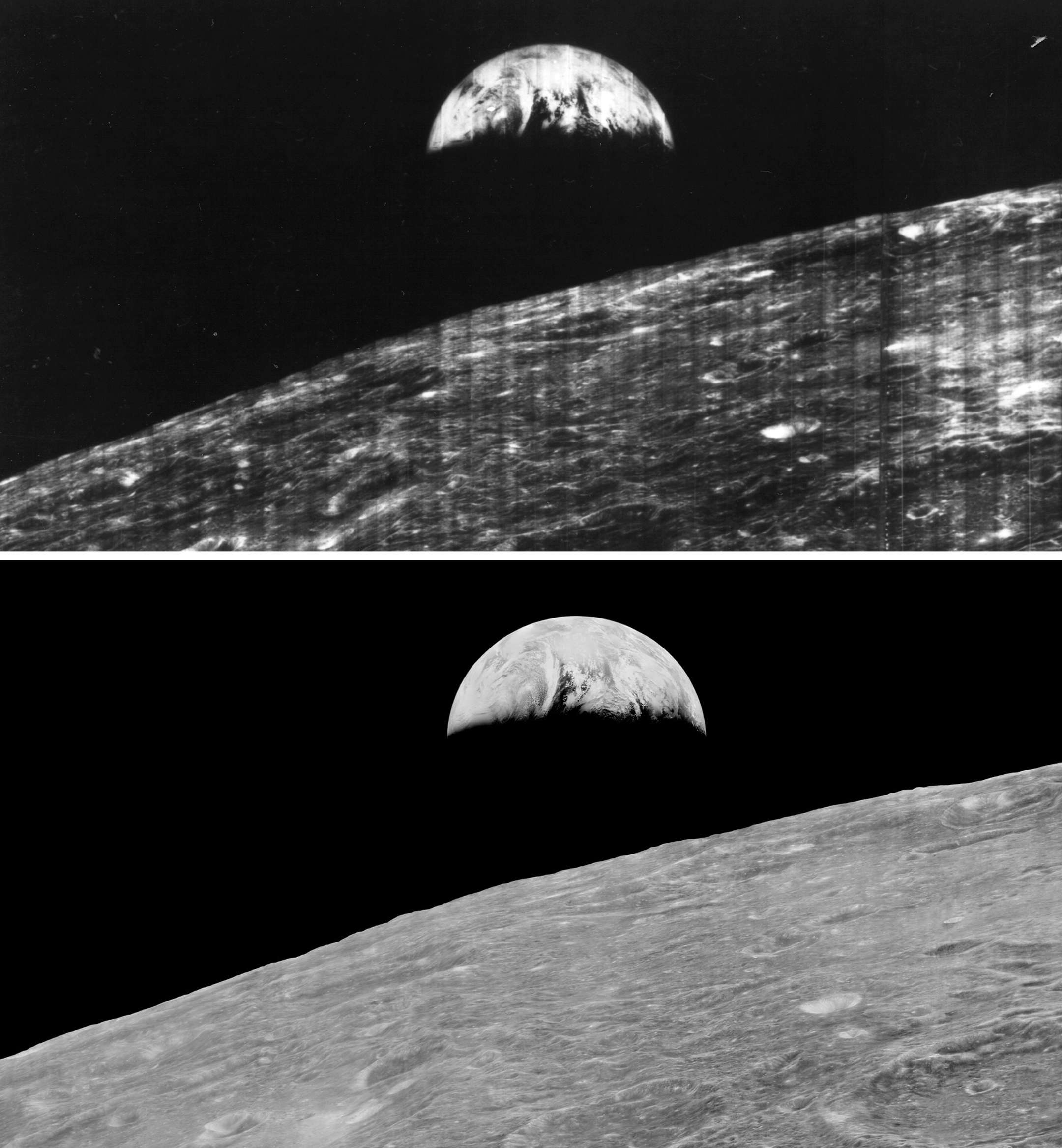
First Earthrise Photo Taken 45 Years Ago Today

![]() Keith’s note: 45 Years ago today, on 23 August 1966, Lunar Orbiter 1 snapped the first photo of Earth as seen from lunar orbit (Larger view). While a remarkable image at the time, the full resolution of the image was never retrieved from the data stored from the mission. In 2008, this earthrise image was restored by the Lunar Orbiter Image Recovery Project at NASA Ames Research Center. We obtained the original data tapes from the mission (the last surviving set) and restored original FR-900 tape drives to operational condition using both 60s era parts and modern electronics. The following links provide background on the image, its restoration, and reactions to its release.
Keith’s note: 45 Years ago today, on 23 August 1966, Lunar Orbiter 1 snapped the first photo of Earth as seen from lunar orbit (Larger view). While a remarkable image at the time, the full resolution of the image was never retrieved from the data stored from the mission. In 2008, this earthrise image was restored by the Lunar Orbiter Image Recovery Project at NASA Ames Research Center. We obtained the original data tapes from the mission (the last surviving set) and restored original FR-900 tape drives to operational condition using both 60s era parts and modern electronics. The following links provide background on the image, its restoration, and reactions to its release.
Here is a comparison of the full image in its original, familiar context (higher res)(print quality). You can download a 1.2 GB version from NASA here. Note: this is a very large file.

– Newly Restored Lunar Orbiter Image of Earth and Moon (Detail)
– How the Photo Was Taken
– House of Representatives Honors Lunar Orbiter Image Recovery Project
– Nimbus II and Lunar Orbiter 1 Imagery: A New Look at Earth in 1966
– Dumpster Diving for Science, Science Magazine
– What Lunar Orbiter 1 Was Seeing on 23 August 1966
LOIRP LPSC Student Poster: New Lunar Crater Search Using LROC-NAC vs LOIRP Lunar Orbiter Images

Click on image for PDF version of poster
Poster presented at the 42nd Lunar and Planetary Science Conference by N. G. Moss, T. M. Harper, M. B. Motta, A. D. Epps
“While some candidate craters were observed that appeared in LROC data but not in Lunar Orbiter data, these were all very near the edge of discernable feature size and are almost certainly explained by various differences between the images (e.g. sun angle or viewing geometry). While our initial search did not find any discernable new cratering, we have shown that data from the original analog Lunar Orbiter tapes, as recovered by the Lunar Orbiter Image Recovery project, possesses the characteristics necessary to discern new craters at reasonably small sizes. If the entire Lunar Orbiter data set was recovered in this manner it may be possible for future researchers to apply automated methods to detect changes with much better chances of success.”
LOIRP LPSC Poster: Recovering Lunar Orbiter Framelets from Digitized Magnetic Tape Record

Click on image for PDF version of poster
Poster presented at the 42nd Lunar and Planetary Science Conference by A. Epps, M. Sandler
“The goal of the Lunar Orbiter Image Recovery Project (LOIRP) is to digitize and archive the magnetic tape records generated by the five Lunar Orbiter spacecraft in the mid-1960s. The readout scanners utilized onboard the Lunar Orbiter spacecraft employed a phosphor-covered anode bombarded by an electron beam to focus a spot of light on 70mm film developed onboard the spacecraft. This light was modulated by the density of the image and read by a photomultiplier tube. Each individual pass of this scanning procedure across the 70mm film produced a thin strip of a larger image, referred to as a “framelet”. The product of the spacecraft’s readout system was a video waveform that was modulated and transmitted to three DSIF stations and recorded onto 2-inch magnetic tape via Ampex FR-900 data recorders. This document discusses the process by which these video signals were converted into digital images.”
Student Project: New Lunar Crater Search Using LROC-NAC Vs LOIRP Lunar Orbiter Images

Figure 1: Lunar Orbiter II sub-frame 2070H2 superimposed on LROC NAC image M116154252LE.
N. G. Moss1 and T. M. Harper2, M. B. Motta3, A. Epps4
1LOIRP Project P.O. Box 375 Moffett Field, CA 94035, Neulynm-at-yahoo.com, 2 LOIRP Project P.O. Box 375 Moffett Field, CA 94035, travis.martin.harper-at-gmail.com. 3 LOIRP Project P.O. Box 375 Moffett Field, CA 94035. Mbmotta-at-yahoo.com., 4Skycorp, Building 596, NASA Ames Research Park, Moffett Field, CA 94035, Austin.epps-at-gmail.com
Submitted to 42nd Lunar and Planetary Science Conference.
Introduction: In 1966 and 1967 NASA sent five Lunar Orbiters to photograph nearly the full surface of the moon. Each orbiter launched took images of different areas of the moons surface, or very high resolution images corresponding to lower resolution images previously taken. Lunar Orbiter Image Recovery Project (LOIRP) is one of the several projects using these images for research. We are in possession of 1,478 2″ original analog tapes from 3 Deep Space Network ground stations. We have taken hundreds of those analog tapes and converted them to digital form; with the majority of them being from Lunar Orbiter II which took images with .8 to 1 meter resolution.
Analysis of Lunar Orbiter Images Recovered From Analog Tape
D. R. Wingo1 and C. J. Byrne2, 1Skycorp Incorporated, P.O. Box 375 Moffett Field, CA, wingod-at-skycorpinc.com, charles.byrne-at-verizon.net
Submitted to 42nd Lunar and Planetary Science Conference
Introduction: The Lunar Orbiter Image Recovery Project (LOIRP) was founded in 2008 with funding from NASA ESMD to recover Lunar Orbiter images from the original 2″ analog magnetic tapes that had been held in protective storage by the National Archives and NASA for 40 years. Of the three central questions that had to be answered for project success, (can the tape drives be brought back to life, are the tapes any good, what is the quality of the data the best available), the final question, whether or not the analog image data on the tapes was superior in quality to the existing film was the ultimate criterion for success.
Continue reading “Analysis of Lunar Orbiter Images Recovered From Analog Tape”
Have You Seen This Large Lunar Orbiter “Earthrise” Presentation from 1966?
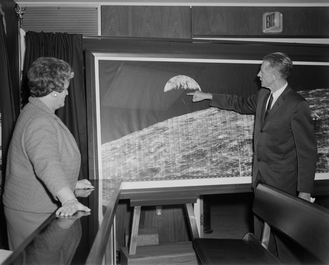
[Click on image to enlarge] Does any one at NASA Langley Research Center (or elsewhere in/around NASA) know where this large reproduction of the Lunar Orbiter 1 “Earthrise” image (or others like it) are currently located? Please drop an email to lunarorbiter-at-spaceref.com – thanks!
Image date: 12.14.1966 Caption: “Langley Center Director Floyd Thompson shows Ann Kilgore the “picture of the century.” This was the first picture of the earth taken from space. From Spaceflight Revolution: “On 23 August 1966 just as Lunar Orbiter I was about to pass behind the moon, mission controllers executed the necessary maneuvers to point the camera away from the lunar surface and toward the earth. The result was the world’s first view of the earth from space. It was called “the picture of the century’ and “the greatest shot taken since the invention of photography.” Not even the color photos of the earth taken during the Apollo missions superseded the impact of this first image of our planet as a little island of life floating in the black and infinite sea of space.” Published in James R. Hansen, Spaceflight Revolution: NASA Langley Research Center From Sputnik to Apollo, (Washington: NASA, 1995), pp. 345-346.”
Image reference at NASAimages.org

“Attached is a photo that I have of the Lunar Orbiter photo. I got if from my Dad who worked for North American Rockwell at the time this photo was taken. Is about 15″ x 40”. And states “Historic First Photo of Earth from Deep Space”. Robert L. Wells, Salem, AL
“Griffith Observatory has a copy of the print, identical in size to the one shown in your story. It was somewhat worse-the-wear for being on public display for decades, and although it had some cosmetic restoration, it was crated and put in storage (where it remains) when the Observatory was closed for renovation in 2002.” – Anthony Cook, Astronomical Observer, Griffith Observatory
“I don’t know if it was a reprint or not, but we had one at Michoud Assembly Facility. It was there from the Saturn program. It hung on the Main isle. West side of the plant, on the north wall. It was across from the Mechanical Assembly area. Think around column K-4, but can’t stake my life on the exact column number. Hope this helps, maybe give them a call.” – Danny

Click on image to enlarge. “Hello… I wished that I had the large version in the story but I have had the smaller version since the 60’s rolled up for a number of years and finally had the print framed about 25 years ago. Right now, it is in storage. As you can see, I brought it out to show some friends for a time and took a photo of it in front of my front door…. It is in fairly good shape, still. It was given to me from a friend that worked at JPL. It is one of my prized pictures and it is heart breaking that I don’t have a wall to display it…. “ Ernie Williams Cerritos, CA
Video: Zoom in On The Restored Copernicus “Picture of the Century”
This high resolution image, subframe 2162_H3, was taken by Lunar Orbiter 2 on 24 November 1966 at 00:05:42 GMT. The crater Copernicus is shown at an oblique angle. This video is from an enhanced version of the original image produced by the Lunar Orbiter Image Recovery Project (LOIRP). Using better-tuned equipment and experience gained along the way, we decided to make a second pass at this wonderous photo. The result was worth the effort.
The original high resolution subframes can be seen below – or here: subframe 2162_H3, subframe 2162_H2, subframe 2162_H1
LOIRP Releases Enhanced Restored Version of the “Image of the Century” Plus Additional Subframes of Crater Copernicus, August 2009
Newly Restored “Picture of the Century”: Lunar Orbiter 2’s View of Copernicus, August 2009
Lunar Orbiter 2 subframe 2112_H3

This high resolution image, subframe 2111_H3, was taken by Lunar Orbiter 2 on 22 November 1966 at 13:49:11 GMT LPI reference Images: [Medium] [Large]