Technoarchaeology: 40 Year Old Mariner 5 Solar Wind Problem Finds Answer

Research led by astrophysicists at the University of Warwick has resolved a 40 year old problem with observations of turbulence in the solar wind first made by the probe Mariner Five. The research resolves an issue with what is by far the largest and most interesting natural turbulence lab accessible to researchers today.
Our current understanding tells us that turbulence in the solar wind should not be affected by the speed and direction of travel of that solar wind. However when the first space probes attempted to measure that turbulence they found their observations didn’t quite match that physical law. The first such data to be analysed from Mariner 5 in 1971 found a small but nonetheless irritatingly clear pattern in the turbulence perpendicular to both the direction of the travel and the magnetic field the solar wind was travelling through.

Continue reading “Technoarchaeology: 40 Year Old Mariner 5 Solar Wind Problem Finds Answer”

Lee Scherer

Lee Scherer, KSC’s 2nd leader, dies at 91, Florida Today
“Lee Scherer, who led Kennedy Space Center through its last major transition between human spaceflight programs, will be remembered in a service later this month near his home in San Diego, Calif. Scherer, KSC’s second center director from 1975 to 1979, died May 7 at age 91. … Joining NASA in 1962 on loan from the Navy, Scherer managed a program that launched five lunar orbiters mapping Apollo landing sites.”
Keith’s note: We were beyond thrilled to have Lee Scherer visit our Lunar Orbiter Image Recovery Project (LOIRP) operation at NASA Ames in November 2008 as we released the newly retrieved and restored “Earthrise” image taken by Lunar Orbiter 1 in 1966. As he walked into Building 596 (aka “McMoons” – it used to be a McDonalds) Lee was clearly stunned to see that we had found all of this old stuff and got it working again. We all had a tear in our eyes – it was like being in a Star Trek episode where something comes back from the past to a future where it simply should not exist.
At one point Lee told a story about some kids in his neighborhood who asked about an old picture he had hanging in his garage. Of course, it was the famous Earthrise image. You can imagine his reaction to seeing it presented in all its glory in a way not possible (technically) in 1966 – but in a way that now truly matched what one’s mind’s eye saw when this image first went viral in 1966. More than a generation later this image inspired the mission patch for STS-130 – the shuttle flight that carried a piece of the summit of Mt. Everest and four small Apollo 11 moon rocks that had been to the summit up to the International Space Station. The past meets the future once again.
Ad astra Lee.


(L to R) Greg Schmidt (NLSI), astronaut Yvonne Cagle, Lee Scherer, Lee’s son, and LOIRP co-lead Dennis Wingo. Next to Lee Scherer are the original Lunar Orbiter tapes still backed in their archival containers.


(L to R) LOIRP co-lead Dennis Wingo, Lee Scherer, LOIRP engineer Ken Zin, and Nancy Evans. Ken ZIn is explainin gthe restoration process hwereby orignal FR-900 tape drives were brought back to life after 40 years.


(L to R) Lee Scherer, Nancy Evans, and Dennis Wingo stand in front of a restored FR-900 tape drive


Lee Scherer signs the newly operational FR-900 tape drive used to read the original Lunar Orbiter data tapes.


TheLunar Orbiter 1 “Earthrise” image of Earth taken on 23 August 1966. Top: original- bottom: restored by LOIRP.

FR-900 Tape Drives and Lunar Orbiter Featured In Ampex Readout Newsletter April 1967

Note: Thanks to Al Kossow at the Computer History Museum for finding and scanning these pages in for us.
Excerpt: “Fifty Years of Data in One Week Recently, Oran W. Nicks, NASA’s Director of Lunar and Planetary Programs, remarked: “one astronomer has said that more information has been obtained in the first seven days of the Lunar Orbiter I project than in the last 50 years of study of the Moon.” Truly, the matchless cooperation and inspired creativity exhibited in the design and construction of Lunar Orbiter spacecraft and, supporting equipment by NASA, the scientific community, and American industry has helped us to take those longer-strides that President Kennedy called for in 1961 when he first spoke of the Apollo landing of a man on the Moon and returning him safely to the earth. Preceeding our men on the Moon, are three unmanned missions that are mapping possible landing areas, testing surface strength and composition, and establishing the launch, guidance and navigation technology, for a successful manned excursion. Ranger (now completed) and Surveyor are managed by Jet Propulsion Laboratory in Pasadena, California. Overall Lunar Orbiter management is by the Langley Research Center, Hampton, Virginia. The Jet Propulsion Laboratory provides tracking and data acquisition support for the Orbiter program.”
Newsletter is presented below

Continue reading “FR-900 Tape Drives and Lunar Orbiter Featured In Ampex Readout Newsletter April 1967”

NASA Lunar Orbiter Video: Assignment, Shoot the Moon (1967)

National Archives: “This film summarizes the exploration of the Moon conducted through unmanned Ranger, Surveyor and Lunar Orbiter spacecraft, and shows how such detailed data and photography contributed to the first manned flights to the Moon. The film describes the complexities of closeup photography of the Moon, and includes good views of craters, mountain ranges and other lunar terrain. This film received the following awards: Golden Eagle Certificate, Council on International Nontheatrical Events (CINE), 1968; and the Award of Merit, American Film Festival, 1968.”
Transcript below

Continue reading “NASA Lunar Orbiter Video: Assignment, Shoot the Moon (1967)”

Have You Seen This Large Lunar Orbiter “Earthrise” Presentation from 1966?


[Click on image to enlarge] Does any one at NASA Langley Research Center (or elsewhere in/around NASA) know where this large reproduction of the Lunar Orbiter 1 “Earthrise” image (or others like it) are currently located? Please drop an email to lunarorbiter-at-spaceref.com – thanks!
Image date: 12.14.1966 Caption: “Langley Center Director Floyd Thompson shows Ann Kilgore the “picture of the century.” This was the first picture of the earth taken from space. From Spaceflight Revolution: “On 23 August 1966 just as Lunar Orbiter I was about to pass behind the moon, mission controllers executed the necessary maneuvers to point the camera away from the lunar surface and toward the earth. The result was the world’s first view of the earth from space. It was called “the picture of the century’ and “the greatest shot taken since the invention of photography.” Not even the color photos of the earth taken during the Apollo missions superseded the impact of this first image of our planet as a little island of life floating in the black and infinite sea of space.” Published in James R. Hansen, Spaceflight Revolution: NASA Langley Research Center From Sputnik to Apollo, (Washington: NASA, 1995), pp. 345-346.”
Image reference at NASAimages.org


“Attached is a photo that I have of the Lunar Orbiter photo. I got if from my Dad who worked for North American Rockwell at the time this photo was taken. Is about 15″ x 40”. And states “Historic First Photo of Earth from Deep Space”. Robert L. Wells, Salem, AL
“Griffith Observatory has a copy of the print, identical in size to the one shown in your story. It was somewhat worse-the-wear for being on public display for decades, and although it had some cosmetic restoration, it was crated and put in storage (where it remains) when the Observatory was closed for renovation in 2002.” – Anthony Cook, Astronomical Observer, Griffith Observatory
“I don’t know if it was a reprint or not, but we had one at Michoud Assembly Facility. It was there from the Saturn program. It hung on the Main isle. West side of the plant, on the north wall. It was across from the Mechanical Assembly area. Think around column K-4, but can’t stake my life on the exact column number. Hope this helps, maybe give them a call.” – Danny


Click on image to enlarge. “Hello… I wished that I had the large version in the story but I have had the smaller version since the 60’s rolled up for a number of years and finally had the print framed about 25 years ago. Right now, it is in storage. As you can see, I brought it out to show some friends for a time and took a photo of it in front of my front door…. It is in fairly good shape, still. It was given to me from a friend that worked at JPL. It is one of my prized pictures and it is heart breaking that I don’t have a wall to display it…. “ Ernie Williams Cerritos, CA

Destination Moon: A History of the Lunar Orbiter Program

Bruce K. Byers, NASA Headquarters, Washington, D.C. 1977, NASA TM X-3487 PDF HTML
“In June 1967, as a member of the NASA History Office Summer Seminar, I began work on a history of the Lunar Orbiter Program, then in its operational phase. My objective was to document the origins of the program and to record the activity of the missions in progress. I also wanted to study the technical and management aspects of the lunar orbital reconnaissance that would provide the Apollo Program with photographic and selenodetic data for evaluating the proposed astronaut landing sites.”

Continue reading “Destination Moon: A History of the Lunar Orbiter Program”

Analyzing Old NASA Apollo Seismometer Data Reveals That The Moon Has An Earth-Like Core

State-of-the-art seismological techniques applied to Apollo-era data suggest our moon has a core similar to Earth’s. Uncovering details about the lunar core is critical for developing accurate models of the moon’s formation. The data sheds light on the evolution of a lunar dynamo — a natural process by which our moon may have generated and maintained its own strong magnetic field.
The team’s findings suggest the moon possesses a solid, iron-rich inner core with a radius of nearly 150 miles and a fluid, primarily liquid-iron outer core with a radius of roughly 205 miles. Where it differs from Earth is a partially molten boundary layer around the core estimated to have a radius of nearly 300 miles. The research indicates the core contains a small percentage of light elements such as sulfur, echoing new seismology research on Earth that suggests the presence of light elements — such as sulfur and oxygen — in a layer around our own core.
Image; A partial view of the Apollo 16 Apollo Lunar Surface Experiments Package (ALSEP) in deployed configuration on the lunar surface as photographed during the mission’s first extravehicular activity (EVA-1), on April 21, 1972. The Passive Seismic Experiment (PSE) is in the foreground center; Central Station (C/S) is in center background, with the Radioisotope Thermoelectric Generator (RTG) to the left. One of the anchor flags for the Active Seismic Experiment (ASE) is at right. high res (1.5 M) low res (116 K)

Continue reading “Analyzing Old NASA Apollo Seismometer Data Reveals That The Moon Has An Earth-Like Core”

Extreme NASA Technoarchaeology

Israel to put Dead Sea scrolls online, AFP
“The Dead Sea scrolls, containing some of the oldest-known surviving biblical texts, are to go online as part of a collaboration between Israeli antiquities authorities and Google, developers said on Tuesday. The 3.5 million dollar (2.5 million euro) project by the Israeli Antiquities Authority and the Internet giant’s local R&D division aims to use space-age technology to produce the clearest renderings yet of the ancient scrolls and make them available free of charge to the public. “This is the most important discovery of the 20th century, and we will be sharing it with the most advanced technology of the next century,” IAA project director Pnina Shor told reporters in Jerusalem. The IAA will begin by using multi-spectral imaging technology developed by the U.S. National Aeronautics and Space Administration to produce high-resolution images of the sometimes-faded texts that may reveal new letters and words.”

Technoarchaeology: Nimbus and LOIRP

NASA Solicitation: Retrieval of Nimbus Observational Data
“NASA/GSFC intends to purchase the items from HOV Services, LLC. Two types of high-end photo scanners are required to scan Nimbus film data: the first must be equivalent to the Leica air photo scanners used to scan NASA’s Heat Capacity mapping Mission frames for the CDMP. Nimbus film was processed on similar devices as HCMM film. The Second is a film scanner normally used for scanning medical X-rays. This type of device is needed to digitize the longer (i.e., 21″) film scenes at 600 dpi. This film is similar to the old B&W satellite film from Defense Meteorological Satellite Program. The facilities need to be located within 50 miles of the NASA’s film archive at GSFC and WNRC. This allows for Government inspection of the scanning and indexing process and ensures the per-image shipping costs are at a minimum with respect to the per-image scanning costs. HOV Services has unique experience in configuring both scanners needed for NASA-type film archives, scanning and indexing all of the NASA film from HCMM mission as part of the NOAA Climate Data Modernization Program (CDMP). NOAA CDMP has partnered with HOV Services since 1999 to digitize and index Defense Meteorological Satellite film records that are from the same era as the Nimbus Film records.”
Nimbus II and Lunar Orbiter 1 Imagery: A New Look at Earth in 1966
National Snow and Ice Data Center on LOIRP
LOIRP Aids In Finding Google Earth Images from 1966
Dumpster Diving for Science

Man’s First Look at Earth From the Moon….

NASA SP-168 EXPLORING SPACE WITH A CAMERA
ORBITER I
Describing the spectacular, historic view above, FLOYD L. THOMPSON, then Director, Langley Research Center, wrote: “At 16:35 GMT on August 23, 1966, the versatile manmade Lunar Orbiter spacecraft responded to a series of commands sent to it from Earth, across a quarter-million miles of space, and made this over-the-shoulder view of its home planet from a vantage point 730 miles above the far side of the Moon.
“At that moment,” Thompson continued, “the Sun was setting along an arc extending from England [on the right] to Antarctica [on the left]. Above that line, the world, with the east coast of the United States at the top, was still bathed in afternoon sunlight. Below, the major portion of the African Continent and the Indian Ocean were shrouded in the darkness of evening. “By this reversal of viewpoint, we here on the…
… and an Oblique View of the Moon Itself
….Earth have been provided a sobering glimpse of the spectacle of our own planet as it will be seen by a few of our generation in their pursuit of the manned exploration of space. We have achieved the ability to contemplate ourselves from afar and thus, in a measure, accomplish the wish expressed by Robert Burns: ‘To see oursels as ithers see us! ”
Also visible in dramatic new perspective in this photograph is the singularly bleak Iunar landscape, its tortured features evidently hammered out by a cosmic bombardment that may have extended over billions of years.
Because the airless, weatherless Moon appears to preserve its surface materials so well, it may serve science as an illuminating record of past events in the solar system. ROBERT JASTROW, Director Goddard Institute for Space Studies, has called the Moon “the Rosetta Stone of the planets.”

To Behold the Moon: The Lunar Orbiter Project

To Behold the Moon: The Lunar Orbiter Project. Chapter 10, Spaceflight Revolution, NASA SP-4308
But, Cliff, you said we weren’t going to improvise like this….
But, listen to what I say now! We’ve worked out the numbers. It’s worth the risk.

– Conversation between Boeing engineer project manager Robert J. Helberg and Clifford H. Nelson, head of Langley’s Lunar Orbiter Project Office, concerning a change in the mission plan for Lunar Orbiter 1.
The bold plan for an Apollo mission based on LOR held the promise of landing on the moon by 1969, but it presented many daunting technical difficulties. Before NASA could dare attempt any type of lunar landing, it had to learn a great deal more about the destination. Although no one believed that the moon was made of green cheese, some lunar theories of the early 1960s seemed equally fantastic. One theory suggested that the moon was covered by a layer of dust perhaps 50 feet thick. If this were true, no spacecraft would be able to safely land on or take off from the lunar surface. Another theory claimed that the moon’s dust was not nearly so thick but that it possessed an electrostatic charge that would cause it to stick to the windows of the lunar landing vehicle, thus making it impossible for the astronauts to see out as they landed. Cornell University astronomer Thomas Gold warned that the moon might even be composed of a spongy material that would crumble upon impact.1
At Langley, Dr. Leonard Roberts, a British mathematician in Clint Brown’s Theoretical Mechanics Division, pondered the riddle of the lunar [312] surface and drew an equally pessimistic conclusion. Roberts speculated that because the moon was millions of years old and had been constantly bombarded without the protection of an atmosphere, its surface was most likely so soft that any vehicle attempting to land on it would sink and be buried as if it had landed in quicksand. After the president’s commitment to a manned lunar landing in 1961, Roberts began an extensive three year research program to show just what would happen if an exhaust rocket blasted into a surface of very thick powdered sand. His analysis indicated that an incoming rocket would throw up a mountain of sand, thus creating a big rim all the way around the outside of the landed spacecraft. Once the spacecraft settled, this huge bordering volume of sand would collapse, completely engulf the spacecraft, and kill its occupants.2
Telescopes revealed little about the nature of the lunar surface. Not even the latest, most powerful optical instruments could see through the earth’s atmosphere well enough to resolve the moon’s detailed surface features. Even an object the size of a football stadium would not show up on a telescopic photograph, and enlarging the photograph would only increase the blur. To separate fact from fiction and obtain the necessary information about the craters, crevices, and jagged rocks on the lunar surface, NASA would have to send out automated probes to take a closer look.
The first of these probes took off for the moon in January 1962 as part of a NASA project known as Ranger. A small 800-pound spacecraft was to make a “hard landing,” crashing to its destruction on the moon. Before Ranger crashed, however, its on-board multiple television camera payload was to send back close views of the surface -views far more detailed than any captured by a telescope. Sadly, the first six Ranger probes were not successful. Malfunctions of the booster or failures of the launch-vehicle guidance system plagued the first three attempts; malfunctions of the spacecraft itself hampered the fourth and fifth probes; and the primary experiment could not take place during the sixth Ranger attempt because the television equipment would not transmit. Although these incomplete missions did provide some extremely valuable high-resolution photographs, as well as some significant data on the performance of Ranger’s systems, in total the highly publicized record of failures embarrassed NASA and demoralized the Ranger project managers at JPL. Fortunately, the last three Ranger flights in 1964 and 1965 were successful. These flights showed that a lunar landing was possible, but the site would have to be carefully chosen to avoid craters and big boulders.3
JPL managed a follow-on project to Ranger known as Surveyor. Despite failures and serious schedule delays, between May 1966 and January 1968, six Surveyor spacecraft made successful soft landings at predetermined points on the lunar surface. From the touchdown dynamics, surface-bearing strength measurements, and eye-level television scanning of the local surface conditions, NASA learned that the moon could easily support the impact and the weight of a small lander. Originally, NASA also [313] planned for (and Congress had authorized) a second type of Surveyor spacecraft, which instead of making a soft landing on the moon, was to be equipped for high-resolution stereoscopic film photography of the moon’s surface from lunar orbit and for instrumented measurements of the lunar environment. However, this second Surveyor or “Surveyor Orbiter” did not materialize. The staff and facilities of JPL were already overburdened with the responsibilities for Ranger and “Surveyor Lander”; they simply could not take on another major spaceflight project.4
In 1963, NASA scrapped its plans for a Surveyor Orbiter and turned its attention to a lunar orbiter project that would not use the Surveyor spacecraft system or the Surveyor launch vehicle, Centaur. Lunar Orbiter would have a new spacecraft and use the Atlas-Agena D to launch it into space. Unlike the preceding unmanned lunar probes, which were originally designed for general scientific study, Lunar Orbiter was conceived after a manned lunar landing became a national commitment. The project goal from the start was to support the Apollo mission. Specifically, Lunar Orbiter was designed to provide information on the lunar surface conditions most relevant to a spacecraft landing. This meant, among other things, that its camera had to be sensitive enough to capture subtle slopes and minor protuberances and depressions over a broad area of the moon’s front side. As an early working group on the requirements of the lunar photographic mission had determined, Lunar Orbiter had to allow the identification of 45-meter objects over the entire facing surface of the moon, 4.5-meter objects in the “Apollo zone of interest,” and 1.2-meter objects in all the proposed landing areas.5
Five Lunar Orbiter missions took place. The first launch occurred in August 1966 within two months of the initial target date. The next four Lunar Orbiters were launched on schedule; the final mission was completed in August 1967, barely a year after the first launch. NASA had planned five flights because mission reliability studies had indicated that five might be necessary to achieve even one success. However, all five Lunar Orbiters were successful, and the prime objective of the project, which was to photograph in detail all the proposed landing sites, was met in three missions. This meant that the last two flights could be devoted to photographic exploration of the rest of the lunar surface for more general scientific purposes. The final cost of the program was not slight: it totaled $163 million, which was more than twice the original estimate of $77 million. That increase, however, compares favorably with the escalation in the price of similar projects, such as Surveyor, which had an estimated cost of $125 million and a final cost of $469 million.
In retrospect, Lunar Orbiter must be, and rightfully has been, regarded as an unqualified success. For the people and institutions responsible, the project proved to be an overwhelmingly positive learning experience on which greater capabilities and ambitions were built. For both the prime contractor, the Boeing Company, a world leader in the building of….

[314]

Lunar Orbiter above the lunar surface.

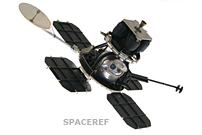
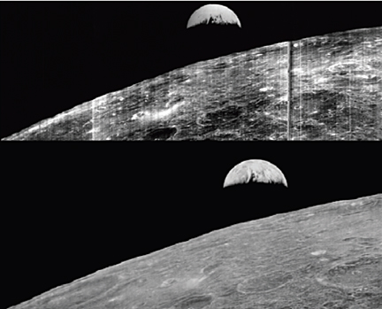
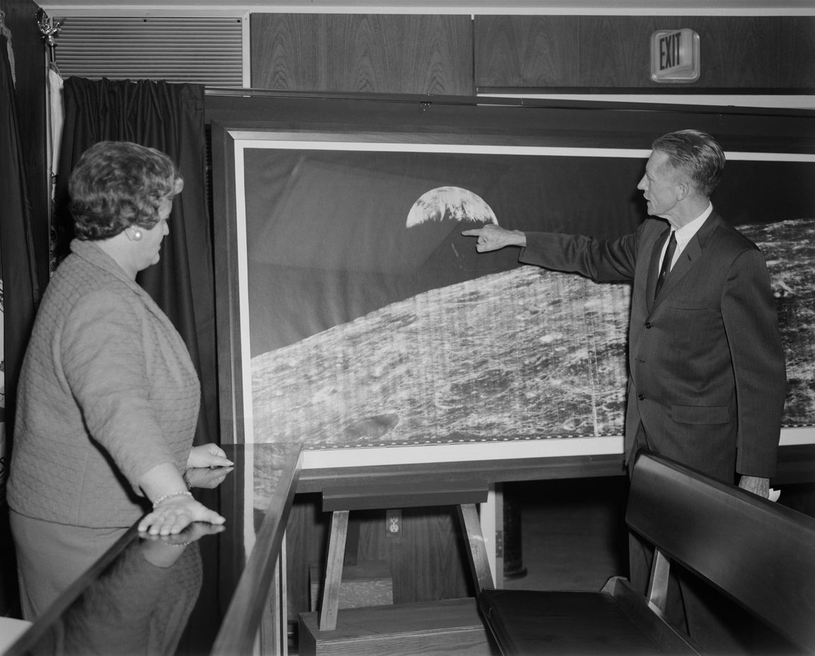
The most successful of the pre-Apollo probes, Lunar Orbiter mapped the equatorial regions of the moon and gave NASA the data it needed to pinpoint ideal landing spots.

Continue reading “To Behold the Moon: The Lunar Orbiter Project”