Lee Scherer

Lee Scherer, KSC’s 2nd leader, dies at 91, Florida Today
“Lee Scherer, who led Kennedy Space Center through its last major transition between human spaceflight programs, will be remembered in a service later this month near his home in San Diego, Calif. Scherer, KSC’s second center director from 1975 to 1979, died May 7 at age 91. … Joining NASA in 1962 on loan from the Navy, Scherer managed a program that launched five lunar orbiters mapping Apollo landing sites.”
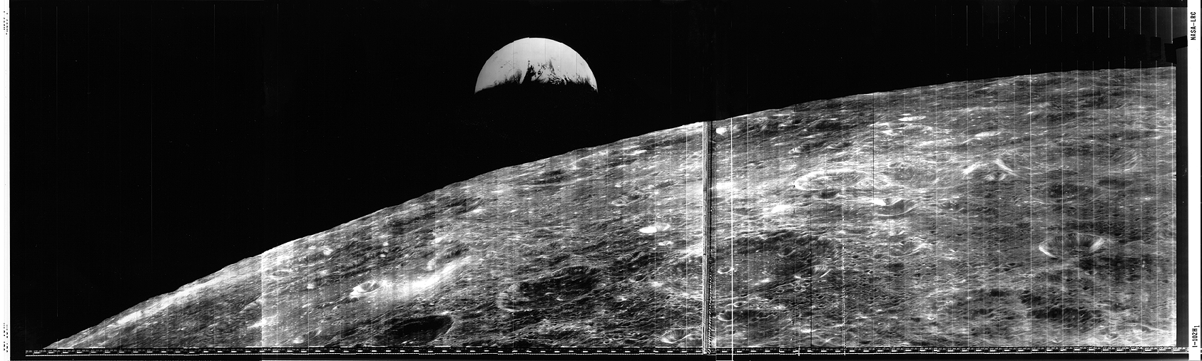
Keith’s note: We were beyond thrilled to have Lee Scherer visit our Lunar Orbiter Image Recovery Project (LOIRP) operation at NASA Ames in November 2008 as we released the newly retrieved and restored “Earthrise” image taken by Lunar Orbiter 1 in 1966. As he walked into Building 596 (aka “McMoons” – it used to be a McDonalds) Lee was clearly stunned to see that we had found all of this old stuff and got it working again. We all had a tear in our eyes – it was like being in a Star Trek episode where something comes back from the past to a future where it simply should not exist.
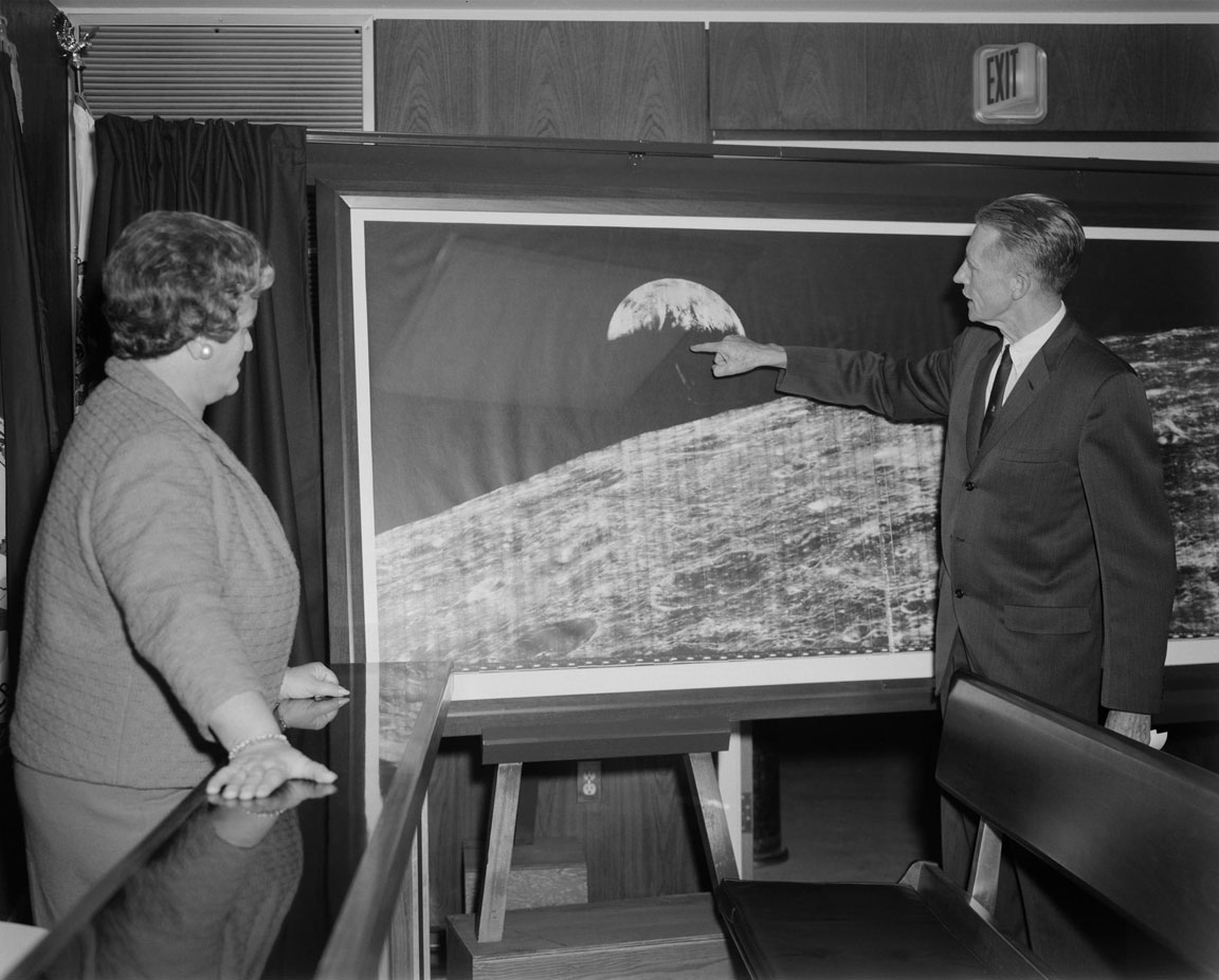
At one point Lee told a story about some kids in his neighborhood who asked about an old picture he had hanging in his garage. Of course, it was the famous Earthrise image. You can imagine his reaction to seeing it presented in all its glory in a way not possible (technically) in 1966 – but in a way that now truly matched what one’s mind’s eye saw when this image first went viral in 1966. More than a generation later this image inspired the mission patch for STS-130 – the shuttle flight that carried a piece of the summit of Mt. Everest and four small Apollo 11 moon rocks that had been to the summit up to the International Space Station. The past meets the future once again.
Ad astra Lee.


(L to R) Greg Schmidt (NLSI), astronaut Yvonne Cagle, Lee Scherer, Lee’s son, and LOIRP co-lead Dennis Wingo. Next to Lee Scherer are the original Lunar Orbiter tapes still backed in their archival containers.


(L to R) LOIRP co-lead Dennis Wingo, Lee Scherer, LOIRP engineer Ken Zin, and Nancy Evans. Ken ZIn is explainin gthe restoration process hwereby orignal FR-900 tape drives were brought back to life after 40 years.


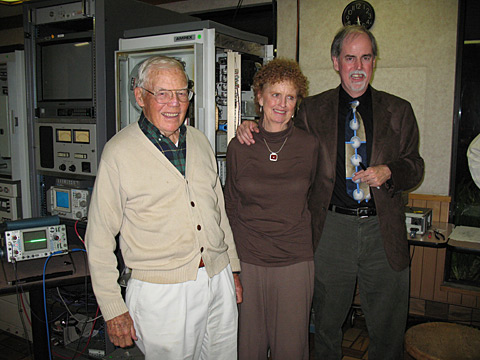
(L to R) Lee Scherer, Nancy Evans, and Dennis Wingo stand in front of a restored FR-900 tape drive


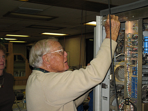
Lee Scherer signs the newly operational FR-900 tape drive used to read the original Lunar Orbiter data tapes.


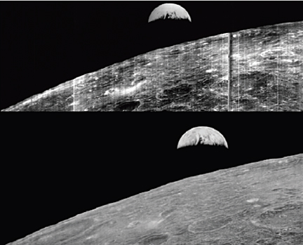
TheLunar Orbiter 1 “Earthrise” image of Earth taken on 23 August 1966. Top: original- bottom: restored by LOIRP.

Have You Seen This Large Lunar Orbiter “Earthrise” Presentation from 1966?


[Click on image to enlarge] Does any one at NASA Langley Research Center (or elsewhere in/around NASA) know where this large reproduction of the Lunar Orbiter 1 “Earthrise” image (or others like it) are currently located? Please drop an email to lunarorbiter-at-spaceref.com – thanks!
Image date: 12.14.1966 Caption: “Langley Center Director Floyd Thompson shows Ann Kilgore the “picture of the century.” This was the first picture of the earth taken from space. From Spaceflight Revolution: “On 23 August 1966 just as Lunar Orbiter I was about to pass behind the moon, mission controllers executed the necessary maneuvers to point the camera away from the lunar surface and toward the earth. The result was the world’s first view of the earth from space. It was called “the picture of the century’ and “the greatest shot taken since the invention of photography.” Not even the color photos of the earth taken during the Apollo missions superseded the impact of this first image of our planet as a little island of life floating in the black and infinite sea of space.” Published in James R. Hansen, Spaceflight Revolution: NASA Langley Research Center From Sputnik to Apollo, (Washington: NASA, 1995), pp. 345-346.”
Image reference at NASAimages.org


“Attached is a photo that I have of the Lunar Orbiter photo. I got if from my Dad who worked for North American Rockwell at the time this photo was taken. Is about 15″ x 40”. And states “Historic First Photo of Earth from Deep Space”. Robert L. Wells, Salem, AL
“Griffith Observatory has a copy of the print, identical in size to the one shown in your story. It was somewhat worse-the-wear for being on public display for decades, and although it had some cosmetic restoration, it was crated and put in storage (where it remains) when the Observatory was closed for renovation in 2002.” – Anthony Cook, Astronomical Observer, Griffith Observatory
“I don’t know if it was a reprint or not, but we had one at Michoud Assembly Facility. It was there from the Saturn program. It hung on the Main isle. West side of the plant, on the north wall. It was across from the Mechanical Assembly area. Think around column K-4, but can’t stake my life on the exact column number. Hope this helps, maybe give them a call.” – Danny


Click on image to enlarge. “Hello… I wished that I had the large version in the story but I have had the smaller version since the 60’s rolled up for a number of years and finally had the print framed about 25 years ago. Right now, it is in storage. As you can see, I brought it out to show some friends for a time and took a photo of it in front of my front door…. It is in fairly good shape, still. It was given to me from a friend that worked at JPL. It is one of my prized pictures and it is heart breaking that I don’t have a wall to display it…. “ Ernie Williams Cerritos, CA

1966: A restored ‘Earthrise’

1966: A restored ‘Earthrise’, MSNBC
“In 1966 and 1967, NASA sent a series of Lunar Orbiter spacecraft to collect detailed images of moon’s surface in preparation for the Apollo program. The tapes were then put in storage. Decades later, researchers with the Lunar Orbiter Image Recovery Project collected the vintage hardware required to play back the imagery. That imagery was digitized , reproducing the images at a much higher resolution than previously possible. On Nov. 11, 2008, the project researchers released this enhanced photograph of Earth rising above the lunar surface, originally made by Lunar Orbiter 1 in 1966. (LOIRP / NASA)”

Nimbus II and Lunar Orbiter 1 Imagery: A New Look at Earth in 1966

On 23 August 1966, the Lunar Orbiter 1 spacecraft took a photo of the Earth as seen from lunar orbit. This image, albeit grainy, quickly became an icon of the Space Age. This “earthrise” photo, while spectacular at the time, was never retrieved and processed to the full level of detail contained in the image. This was due in great part of the available technology at the time. Computer image processing was in its infancy.
Forty two years later, the Lunar Orbiter Image Recovery Project (LOIRP) managed to retrieve the image from original data tapes using restored tape drives from the 1960s. In so doing the level of detail present in the image was unparalleled. Subsequently, other images have been retrieved with the ultimate goal of obtaining all of the images returned by the five Lunar Orbiters.
One of the striking aspects of this newly enhanced image is the amount of detail that can be seen on Earth at a resolution of perhaps 1 km/pixel taken from a quarter of a million miles away. Among the details visible is the extent of the southern polar ice cap.
The LOIRP required a lot of what has come to be called “techoarchaeology” that is, going back in time to the original data and recording devices, using modern enhancements. The expertise gained by the LOIRP team eventually caught the attention of the folks at the National Snow and Ice Data Center (NSIDC).
Data from the Nimbus weather and earth observation satellite – in orbit at the same time as the Lunar Orbiters were circling the Moon – had languished for years in the national archives until John Moses NASA Goddard Space Flight Center had them digitized.  
Dr. Walt Meir of the National Snow and Ice Data Center, after seeing the work that the LOIRP team had done in potentially identifying the Antarctic sea ice in the Lunar Orbiter 1 Earthrise image, and recognizing the similarity between the raw data of the Nimbus and Lunar Orbiter data, provided a grant to the LOIRP team to process the Nimbus data into a modern format and to correct image artifacts that are common to both types of images.  
The LOIRP team accomplished this, and rendered the images into the Google Earth format using a variety of internally developed techniques and elements of the NASA Ames developed NASA World Wind Java software development kit.
To date some of the images taken by Nimbus II have been enhanced and mapped into Google Earth. One date in particular was of interest to the LOIRP – 23 August 1966. As the images were enhanced and dropped into Google Earth it became clear that we have imagery that overlapped in time to show the weather on that late August day as evening crept up on Africa and Europe.
In New York City, just over the Earth’s limb as seen from lunar orbit, the Beatles were preparing to play at Shea Stadium …
You can download a KMZ file of these images here for viewing in Google Earth.
Related Links
Techno-Archaeology Rescues Climate Data from Early Satellites
LOIRP Aids In Finding Google Earth Images from 1966
Newly Restored Lunar Orbiter Image of Earth and Moon (Detail)


The original Lunar Orbiter 1 image of Earth on 23 August 1966 (click on image to enlarge)


Nimbus II imagery of Earth on 23 August 1966 (click on image to enlarge)


Overlap of Nimbus II imagery onto Lunar Orbiter 1 imagery (click on image to enlarge)

Lunar Echoes on STS-130


The STS-130 patch was designed by the crew to reflect both the objectives of the mission and its place in the history of human spaceflight. The main goal of the mission is to deliver Node 3 and the Cupola to the International Space Station (ISS). Node 3, named “Tranquility,” will contain life support systems enabling continued human presence in orbit aboard the ISS. The shape of the patch represents the Cupola, which is the windowed robotics viewing station, from which astronauts will have the opportunity not only to monitor a variety of ISS operations, but also to study our home planet.
The image of Earth depicted in the patch is the first photograph of the Earth taken from the moon by Lunar Orbiter I on August 23, 1966. As both a past and a future destination for explorers from the planet Earth, the moon is thus represented symbolically in the STS-130 patch.
The Space Shuttle Endeavour is pictured approaching the ISS, symbolizing the Space Shuttle’s role as the prime construction vehicle for the ISS. The NASA insignia design for shuttle flights is reserved for use by the astronauts and for other official use as the NASA Administrator may authorize. Public availability has been approved only in the form of illustrations by the various news media. When and if there is any change in this policy, which we do not anticipate, it will be publicly announced. STS130-S-001 (September 2009) — high res (1.5 M) low res (98 K)

LOIRP Featured by National Geographic

MOON PICTURES: 1960s Orbiter Images Restored, National Geographic
All these steps took their toll on the quality of the images: Much like making a photocopy of a photocopy, the images of the moon created 40 years ago were fairly fuzzy and lacking in detail. But some NASA scientists had the foresight to make magnetic tape recordings of the radio-wave transmissions mid-way through the process. Now, after recovering the decades-old recordings and refurbishing outdated tape drives, a team of volunteers has begun digitizing the most famous images from the 1960s Lunar Orbiter missions with much-improved clarity and detail.
APOLLO 11: New Before-and-After Photos of Moon Bases, National Geographic
“Despite extensive restoration efforts, this photo is fuzzier and grainier than many of the restored 1960s orbiter images because of repeated viewings of the magnetic tape on which the photo was recorded.”

Recovered Lunar Orbiter Image makes Lunar Photo of the Day

Lunar Photo of the Day
“With much fanfare NASA has re-released the earliest US image of the Earth as seen from the Moon. This Orbiter 1 image was originally released in 1966 when it was a unique, never before seen view that dramatically documented our new prowess in space. The recent re-release follows a long saga of saving and repairing the large 40 year old tape drives needed to read the massive tapes that record the data.”

NASA Earth Observatory Features Recovered Lunar Orbiter Image

Earthrise 1966, NASA Earth Observatory
“Long before man journeyed to the moon and looked back at the tiny, fragile planet that houses humanity, remote orbiters were sending back pictures of home. Sent to scope out potential landing sites on the Moon, the series of five Lunar Orbiters also sent back the earliest views of Earth from another celestial body. This image, taken in 1966 by Lunar Orbiter 1, is among the first views of Earth from the Moon. In the black-and-white image, a crescent Earth floats majestically behind the lumpy surface of the Moon. Though clouds swirl across the atmosphere, hiding nearly all identifying features on the surface beneath, the western edge of Africa is faintly visible in the upper left. The Earth’s North Pole points toward the top of the image.”

A Reborn Picture Spawns an Editorial

The Moon View, editorial, New York Times
“Last week, NASA released a newly restored image of a younger Earth. It was taken from Lunar Orbiter 1 in 1966, the first of several orbiters that helped gather data for the first moon landing in 1969. The photograph shows Earth just cresting the Moon’s curving horizon, the first picture of our planet framed by the surface of the Moon.
When the photograph was published, in 1966, it looked like a newsprint version of a high-contrast snapshot from space, a stark scattering of whites and blacks. The data from the lunar orbiter was stored on old analog tape drives. Now, imaging experts at NASA have digitized those drives — mining data that could not be recovered when they were first made — and produced a high-resolution version of that historic photograph.
The rough surface of the moon no longer looks starkly black and white. It has been rendered instead in a broad palette of grays, which give the moonscape a dimensional presence it never had in the photograph that first appeared. The cloud patterns that hide the surface of Earth, a crescent earth, are much more subtle.
What is most evocative is the awareness that this is our planet in 1966, which feels like a very long time ago. A train of thought immediately presents itself. If scientists can recover extensive new information from old electronic data, shouldn’t there be some way to peer beneath those clouds, back in time, and see how this planet looked when it had only half its current population?
It is probably not possible to say that one Earth is ever more innocent than another. And yet there is a feeling of innocence hanging over that beclouded planet, which was just about to get the first glimpse of itself from the Moon.”

Lunar Orbiter in the News 14 November 2008

Repaired data drives restoring the Moon, Collectspace
“Still, it took some experimentation to understand how the data was organized and what was on the tape. “It was not unlike the scene from the movie ‘Contact’ where they think they have a video signal but they are not sure and they sort of monkey with the gear and they plug things in and they say, ‘Hey look! That’s a video signal’. As they play with it further they suddenly say, ‘Oh look, maybe we rotate it that way, flip the contrast,’ and they eventually find out they’ve got a video signal and they’re sitting there and playing with it and ‘Look, more data!’ and that’s how it happened,” described Cowing.”
Odyssey Moon Collaborates with NASA Funded Team Recovering Never Seen Before Detailed Images of the Moon
“In support of the project Odyssey Moon supported the salary of an intern who provided direct support to the project’s refurbishment of the original data tape drives. Odyssey Moon has also provided funding to the team to allow specific areas of the publicly released imagery to be enhanced for use in mission planning.”
Restoring the Moon: Lunar Orbiter Images Recovered, space.com
“Anyone who has used a copy machine to make a copy of a copy knows that resolution is lost in the process. The same was true for Lunar Orbiter, though for NASA, which needed quicker access to the data than computers of that day were able to provide, the resulting images would be what they needed to evaluate landing locations for Apollo.”
NASA restores 42-yr-old image of Earth rising above the lunar surface, Smash Hits, India
NASA goes back in time, IT Examiner, India
NASA releases digital version of iconic Earth image at Moffett Field, The Salinas Californian
NASA and LOIRP Return to the Moon, 42 Years Later. Recovering Lunar Orbiter Images, EDN
New views of the Moon – November 14, 2008, Nature

Keith Cowing: The Image we think we have – detective story

Keith Cowing: This is part of the detective work I used to help narrow down what image we may have found.
1. If you listen to this audio [ http://images.spaceref.com/news/2008/loirptest5.mp3] from a data tape you will hear the technician state that it is an analog copy of an earlier tape – but that it is only a copy of the portion with the Earth and moon on it and that it was originally recorded on GMT date 237.
2. In 1966 day 237 was 25 August. Lunar Orbiter 1 was launched on 10 August 1966 and imaged the moon from 18-29 August 1966.
3. This image of a page from a Lunar Orbiter planning document [ page 70 of Lunar Orbiter I – Photography NASA-CR-847 http://hdl.handle.net/2060/19670023005] clearly shows an image of the Earth from the moon being planed for Lunar Orbiter 1 on day 237.
http://images.spaceref.com/news/2008/day237.earth.moon.jpg
4. Apparently this was attempted more than once. Recall that Lunar Orbiter 1 was the first mission and they had a lot of bugs to work out with the imaging system.
5. According to http://nssdc.gsfc.nasa.gov/imgcat/html/object_page/lo1_h102_123.html Lunar Orbiter 1 took the first two remote images of earth from the distance of the Moon, August 23rd 1966.”
6. This is the series of three images stitched togetehr showing Earthrise above the lunar surface taken on 23 August 1966
http://images.spaceref.com/news/2008/lo1_h102_123.gif
Location & Time Information
Date/Time (UT): 1966-08-23 T 16:36:23
Distance/Range (km): 1476
Central Latitude/Longitude (deg): -14.68/104.34
Orbit(s): N/A
Imaging Information
Area or Feature Type: crater, global view
Instrument:  High-resolution Camera
Instrument Resolution (pixels): N/A
Instrument Field of View (deg): 20.4 x 5.16 
Filter: Clear
Illumination Incidence Angle (deg): 21.30
Phase Angle (deg): 95.07
Instrument Look Direction: N/A
Surface Emission Angle (deg): 80.94
Ordering Information
CD-ROM Volume: N/A
NASA Image ID number: L01-102; H1, H2, H3
Other Image ID number: N/A
NSSDC Data Set ID (Photo): 66-073Z-01D
NSSDC Data Set ID (CD): N/A
Other ID: N/A
7. Apparently there was some controversy about doing things like this with the spacecraft:
“Despite the malfunctions in the photographic subsystem the spacecraft succeeded in taking many historic pictures. Command and maneuver requirements were developed to take, [241] in near real-time, such pictures as those of the morning and evening terminator on the lunar surface, the Earth as seen from the Moon’s vicinity, numerous farside pictures, and additional photographs of sites of interest on the near side. Lunar Orbiter I photographed such areas as potential targets for Mission B, major craters, and mare and upland areas useful as Apollo navigation landmarks and was mostly able to satisfy the requirements to take these photographs.
Of all the pictures which Lunar Orbiter I made, one of the most spectacular was the first photograph of the Earth taken from the vicinity of the Moon. This picture was not included in the original mission plan, and it required that the spacecraft’s attitude in relation to the lunar surface be changed so that the camera’s lenses were pointing away from the Moon. Such maneuvering meant a calculated risk and, coming early in the flight, the unplanned photograph of Earth raised some doubts among Boeing management about the safety of the spacecraft.
Robert J. Helberg, Boeing’s Program Manager for Lunar Orbiter, opposed such a hazardous unnecessary risk. The spacecraft would be pointed away from the Moon so that [242] the camera’s lenses could catch a quick view of Earth tangential to the lunar surface. Then, once the pictures were made (flight controllers would execute two photo sequences on two different orbits), Lunar Orbiter I would disappear behind the Moon where it would not be in communication with ground control. If, for some reason ground control failed to reestablish communications with it, the Apollo-oriented mission photography would probably remain undone, Moreover, Boeing had an incentive riding on the performance of the spacecraft, and Heiberg did not think it prudent to commit the spacecraft to a series of maneuvers for which no plans had been made.30
The understandably conservative Boeing stance was changed through a series of meetings between top NASA program officials, including Dr. Floyd L. Thompson, Clifford H. Nelson, and Lee R. Scherer. They convinced Heiberg that the picture was worth the risk and that NASA would make compensation in the event of an unexpected mishap with the spacecraft. After agreement had been reached, Lunar Orbiter flight controllers executed the necessary maneuvers to point the spacecraft’s camera away from the lunar surface, and on two different orbits (16 and 26) it recorded two unprecedented, very useful photographs.
[243] The Earth-Moon pictures proved valuable for their oblique perspective of the lunar surface. Until these two photographs, all pictures had been taken along axes perpendicular or nearly perpendicular to the Moon’s surface. On subsequent Lunar Orbiter missions oblique photography was planned and used more often.31”
8. We know that we have an image on this particular tape.