Moon Geology and a New Mystery on Mars’ Forgotten Plains


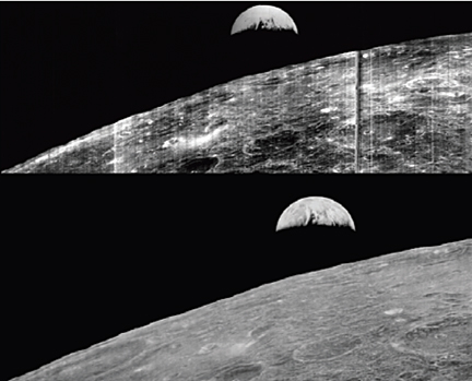
NASA Lunar Orbiter 5 image of the plateau west-northwest of Marius crater on the Moon. Larger Image.
One of the supposedly best understood and least interesting landscapes on Mars is hiding something that could rewrite the planet’s history. Or not. In fact, about all that is certain is that decades of assumptions regarding the wide, flat Hesperia Planum are not holding up very well under renewed scrutiny with higher-resolution, more recent spacecraft data.
“Most scientists don’t want to work on the flat things,” noted geologist Tracy Gregg of The University at Buffalo, State University of New York. So, after early Mars scientists decided Hesperia Planum looked like a lava-filled plain, no one really revisited the matter and the place was used to exemplify something rather important: The base of a major transitional period in the geologic time scale of Mars. The period is aptly called the Hesperian and it is thought to have run from 3.7 to 3.1 billion years ago.
But when Gregg and her student Carolyn Roberts started looking at this classic Martian lava plain with modern data sets, they ran into trouble.
“There’s a volcano in Hesperia Planum that not many people pay attention to because it’s very small,” Gregg said. “As I started looking closer at the broader region — I can’t find any other volcanic vents, any flows. I just kept looking for evidence of lava flows. It’s kind of frustrating. There is nothing like that in the Hesperia Planum.”
“A likely cause of this trouble is the thick dust that blankets Hesperia Planum,” she said. “It covers everywhere like a snowfall.”
So she turned her attention to what could be discerned on Hesperia Planum: about a dozen narrow, sinuous channels, called rilles, just a few hundred meters wide and up to hundreds of kilometers long. These rilles have no obvious sources or destinations and it is not at all clear they are volcanic.


NASA/GSFC/Arizona State University Lunar Reconnaissance Orbiter image “Secrets of Schroeteri” Vallis Schroeteri is a sinuous rille on the moon; its inner rille diverges from the primary rille near arrow. Larger Image.


THEMIS daytime infrared image mosaic (courtesy of ASU/NASA/JPL) of Mars with north is at the top. Image is centered at 116.3 deg E and 25.0 deg S Larger Image. “The question I have is what made the channels,”; said Gregg. Was it water, lava, or something else? “There are some lavas that can be really, really runny. And both are liquids that run downhill.” So either is a possibility.
To begin to sort the matter out, Gregg and Roberts are now looking for help on the Moon. Their preliminary findings will be presented Wednesday, 12 Oct., at the meeting of The Geological Society of America in Minneapolis.
“On the Moon we see these same kinds of features and we know that water couldn’t have formed them there,” Gregg said. So they are in the process of comparing channels on the Moon and Mars, using similar data sets from different spacecraft, to see if that sheds any light on the matter. She hopes to find evidence that will rule out water or lava on Hesperia Planum.
“Everybody assumed these were huge lava flows,” said Gregg. “But if it turns out to be a lake deposit, it’s a very different picture of what Mars was doing at that time.” It would also make Hesperia Planum a good place to look for life, because water plus volcanic heat and minerals is widely believed to be a winning combination for getting life started.
“The ‘volcanic’ part is an interpretation that’s beginning to fall apart,” said Gregg. “What is holding up is that the Hesperian marks a transition between the Noachian (a time of liquid water on the surface and the formation of lots of impact craters) and the Amazonian (a drier, colder Mars).”
She has found that other scientists are interested in her work because of its possible implications on the Mars geological time scale. Gregg is not worried that Mars history will need to be rewritten, but she does suspect that Hesperia Planum is a lot more complicated than people has long thought.
Presentation Time: 3-3:15 PM, Wed., 12 Oct. 2011 Where: Minneapolis Convention Center, Room L100H-J What: 284-6: Sinuous Rilles in Hisperia Planum, Mars: Water, Lava, or Something Else?
Session No. 284: Terrestrial Analogs in Solar System Studies

Video: Comparing Lunar Orbiter and LRO Images of the Apollo 11 Landing Site


This video compares the best Lunar Orbiter Image and one of the best LRO Images of the Apollo 11 landing site. The photos were taken over 40 years apart. The Lunar Orbiter photo was taken in 1967 before Apollo 11 landed on the moon, whereas the LRO image was taken on December 22, 2009 and shows the LM Eagle’s descent stage resting on the lunar surface.
LOIRP Mentioned at Apollo 11 Anniversary Celebration, MoonViews
“Our Apollo 11 landing site image was used to set the context for the LRO picture. Mention was also made of the LOIRP – Lunar Orbiter Image Recovery Project. Here is a video shot with a small camera of Tyson’s comments regarding our image.”
Damaged Tape and Murky Moon Views, MoonViews
“We recently released two Apollo landing site images – Apollo 12 and Apollo 14 and had embarked upon getting an nice crisp image of the Apollo 11 landing site in time for the anniversary.”

Lee Scherer

Lee Scherer, KSC’s 2nd leader, dies at 91, Florida Today
“Lee Scherer, who led Kennedy Space Center through its last major transition between human spaceflight programs, will be remembered in a service later this month near his home in San Diego, Calif. Scherer, KSC’s second center director from 1975 to 1979, died May 7 at age 91. … Joining NASA in 1962 on loan from the Navy, Scherer managed a program that launched five lunar orbiters mapping Apollo landing sites.”
Keith’s note: We were beyond thrilled to have Lee Scherer visit our Lunar Orbiter Image Recovery Project (LOIRP) operation at NASA Ames in November 2008 as we released the newly retrieved and restored “Earthrise” image taken by Lunar Orbiter 1 in 1966. As he walked into Building 596 (aka “McMoons” – it used to be a McDonalds) Lee was clearly stunned to see that we had found all of this old stuff and got it working again. We all had a tear in our eyes – it was like being in a Star Trek episode where something comes back from the past to a future where it simply should not exist.
At one point Lee told a story about some kids in his neighborhood who asked about an old picture he had hanging in his garage. Of course, it was the famous Earthrise image. You can imagine his reaction to seeing it presented in all its glory in a way not possible (technically) in 1966 – but in a way that now truly matched what one’s mind’s eye saw when this image first went viral in 1966. More than a generation later this image inspired the mission patch for STS-130 – the shuttle flight that carried a piece of the summit of Mt. Everest and four small Apollo 11 moon rocks that had been to the summit up to the International Space Station. The past meets the future once again.
Ad astra Lee.


(L to R) Greg Schmidt (NLSI), astronaut Yvonne Cagle, Lee Scherer, Lee’s son, and LOIRP co-lead Dennis Wingo. Next to Lee Scherer are the original Lunar Orbiter tapes still backed in their archival containers.


(L to R) LOIRP co-lead Dennis Wingo, Lee Scherer, LOIRP engineer Ken Zin, and Nancy Evans. Ken ZIn is explainin gthe restoration process hwereby orignal FR-900 tape drives were brought back to life after 40 years.


(L to R) Lee Scherer, Nancy Evans, and Dennis Wingo stand in front of a restored FR-900 tape drive


Lee Scherer signs the newly operational FR-900 tape drive used to read the original Lunar Orbiter data tapes.


TheLunar Orbiter 1 “Earthrise” image of Earth taken on 23 August 1966. Top: original- bottom: restored by LOIRP.

FR-900 Tape Drives and Lunar Orbiter Featured In Ampex Readout Newsletter April 1967

Note: Thanks to Al Kossow at the Computer History Museum for finding and scanning these pages in for us.
Excerpt: “Fifty Years of Data in One Week Recently, Oran W. Nicks, NASA’s Director of Lunar and Planetary Programs, remarked: “one astronomer has said that more information has been obtained in the first seven days of the Lunar Orbiter I project than in the last 50 years of study of the Moon.” Truly, the matchless cooperation and inspired creativity exhibited in the design and construction of Lunar Orbiter spacecraft and, supporting equipment by NASA, the scientific community, and American industry has helped us to take those longer-strides that President Kennedy called for in 1961 when he first spoke of the Apollo landing of a man on the Moon and returning him safely to the earth. Preceeding our men on the Moon, are three unmanned missions that are mapping possible landing areas, testing surface strength and composition, and establishing the launch, guidance and navigation technology, for a successful manned excursion. Ranger (now completed) and Surveyor are managed by Jet Propulsion Laboratory in Pasadena, California. Overall Lunar Orbiter management is by the Langley Research Center, Hampton, Virginia. The Jet Propulsion Laboratory provides tracking and data acquisition support for the Orbiter program.”
Newsletter is presented below

Continue reading “FR-900 Tape Drives and Lunar Orbiter Featured In Ampex Readout Newsletter April 1967”

Student Project: New Lunar Crater Search Using LROC-NAC Vs LOIRP Lunar Orbiter Images

Figure 1: Lunar Orbiter II sub-frame 2070H2 superimposed on LROC NAC image M116154252LE.
N. G. Moss1 and T. M. Harper2, M. B. Motta3, A. Epps4
1LOIRP Project P.O. Box 375 Moffett Field, CA 94035, Neulynm-at-yahoo.com, 2 LOIRP Project P.O. Box 375 Moffett Field, CA 94035, travis.martin.harper-at-gmail.com. 3 LOIRP Project P.O. Box 375 Moffett Field, CA 94035. Mbmotta-at-yahoo.com., 4Skycorp, Building 596, NASA Ames Research Park, Moffett Field, CA 94035, Austin.epps-at-gmail.com

Submitted to 42nd Lunar and Planetary Science Conference.
Introduction: In 1966 and 1967 NASA sent five Lunar Orbiters to photograph nearly the full surface of the moon. Each orbiter launched took images of different areas of the moons surface, or very high resolution images corresponding to lower resolution images previously taken. Lunar Orbiter Image Recovery Project (LOIRP) is one of the several projects using these images for research. We are in possession of 1,478 2″ original analog tapes from 3 Deep Space Network ground stations. We have taken hundreds of those analog tapes and converted them to digital form; with the majority of them being from Lunar Orbiter II which took images with .8 to 1 meter resolution.

Continue reading “Student Project: New Lunar Crater Search Using LROC-NAC Vs LOIRP Lunar Orbiter Images”

A Sixth Orbiter Mission?

Source: DESTINATION MOON: A History of the Lunar Orbiter Program, NASA TM-3487
[303] Even before Lunar Orbiter V flew, the Office of Space Science and Applications was entertaining the prospect of flying a sixth Orbiter mission. Boeing had nearly enough parts to assemble another spacecraft at an initial cost of about $13 million. A gamma-ray experiment also existed which scientists desired to fly on a sixth Orbiter. Its inclusion would raise the cost of the mission by about $3 million. However, the necessity to relocate personnel on the Lunar Orbiter team to other jobs presented a major problem blocking another mission.1

Continue reading “A Sixth Orbiter Mission?”

NASA Lunar Orbiter Video: Assignment, Shoot the Moon (1967)

National Archives: “This film summarizes the exploration of the Moon conducted through unmanned Ranger, Surveyor and Lunar Orbiter spacecraft, and shows how such detailed data and photography contributed to the first manned flights to the Moon. The film describes the complexities of closeup photography of the Moon, and includes good views of craters, mountain ranges and other lunar terrain. This film received the following awards: Golden Eagle Certificate, Council on International Nontheatrical Events (CINE), 1968; and the Award of Merit, American Film Festival, 1968.”
Transcript below

Continue reading “NASA Lunar Orbiter Video: Assignment, Shoot the Moon (1967)”

Destination Moon: A History of the Lunar Orbiter Program

Bruce K. Byers, NASA Headquarters, Washington, D.C. 1977, NASA TM X-3487 PDF HTML
“In June 1967, as a member of the NASA History Office Summer Seminar, I began work on a history of the Lunar Orbiter Program, then in its operational phase. My objective was to document the origins of the program and to record the activity of the missions in progress. I also wanted to study the technical and management aspects of the lunar orbital reconnaissance that would provide the Apollo Program with photographic and selenodetic data for evaluating the proposed astronaut landing sites.”

Continue reading “Destination Moon: A History of the Lunar Orbiter Program”

Dumpster Diving for Science

NASA Dives Into Its Past to Retrieve Vintage Satellite Data, Science (subscription)
“Last month, researchers working out of an abandoned McDonald’s restaurant on the grounds of NASA Ames Research Center recovered data collected by NASA’s Nimbus II satellite on 23 September 1966. The satellite soared over Earth in a polar orbit every 108 minutes, taking pictures of cloud cover and measuring heat radiated from the planet’s surface, and creating a photo mosaic of the globe 43 years ago. The resulting image is the oldest and most detailed from NASA’s Earth-observing satellites. It’s also the latest success story in what researchers call techno-archaeology: pulling data from archaic storage systems. Once forgotten and largely unreadable with modern equipment, old data tapes are providing researchers with new information on changes in the surfaces of Earth and the moon…”
… The LOIRP team obtained $750,000 from NASA and private enterprise and enlisted the assistance of a retired Ampex engineer. They cleaned, rebuilt, and reassembled one drive, then designed and built equipment to convert the analog signals into an exact 16-bit digital copy. “It was like dumpster diving for science,” says Cowing, co-team leader at LOIRP. In November 2008, the team recovered their first image: a famous picture of an earthrise taken by Lunar Orbiter 1 on 23 August 1966. The team’s new high-resolution version was so crisp and clear that it revealed many previously obscured details, such as a fog bank lying along the coast of Chile. “We thought if the Earth’s surface looks that good a quarter of a million miles away, what does the moon’s surface look like 100 miles beneath it?” says Cowing.”

Click on image to enlarge

Nimbus II and Lunar Orbiter 1 Imagery: A New Look at Earth in 1966

On 23 August 1966, the Lunar Orbiter 1 spacecraft took a
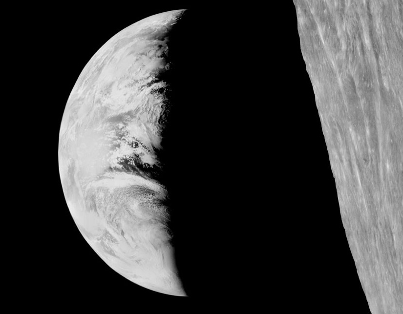
 photo of the Earth as seen from lunar orbit. This image, albeit grainy, quickly became an icon of the Space Age. This “earthrise” photo, while spectacular at the time, was never retrieved and processed to the full level of detail contained in the image. This was due in great part of the available technology at the time. Computer image processing was in its infancy.
Forty two years later, the Lunar Orbiter Image Recovery Project (LOIRP) managed to retrieve the image from original data tapes using restored tape drives from the 1960s. In so doing the level of detail present in the image was unparalleled. Subsequently, other images have been retrieved with the ultimate goal of obtaining all of the images returned by the five Lunar Orbiters.
One of the striking aspects of this newly enhanced image is the amount of detail that can be seen on Earth at a resolution of perhaps 1 km/pixel taken from a quarter of a million miles away. Among the details visible is the extent of the southern polar ice cap.
The LOIRP required a lot of what has come to be called “techoarchaeology” that is, going back in time to the original data and recording devices, using modern enhancements. The expertise gained by the LOIRP team eventually caught the attention of the folks at the National Snow and Ice Data Center (NSIDC).
Data from the Nimbus weather and earth observation satellite – in orbit at the same time as the Lunar Orbiters were circling the Moon – had languished for years in the national archives until John Moses NASA Goddard Space Flight Center had them digitized.  
Dr. Walt Meir of the National Snow and Ice Data Center, after seeing the work that the LOIRP team had done in potentially identifying the Antarctic sea ice in the Lunar Orbiter 1 Earthrise image, and recognizing the similarity between the raw data of the Nimbus and Lunar Orbiter data, provided a grant to the LOIRP team to process the Nimbus data into a modern format and to correct image artifacts that are common to both types of images.  
The LOIRP team accomplished this, and rendered the images into the Google Earth format using a variety of internally developed techniques and elements of the NASA Ames developed NASA World Wind Java software development kit.
To date some of the images taken by Nimbus II have been enhanced and mapped into Google Earth. One date in particular was of interest to the LOIRP – 23 August 1966. As the images were enhanced and dropped into Google Earth it became clear that we have imagery that overlapped in time to show the weather on that late August day as evening crept up on Africa and Europe.
In New York City, just over the Earth’s limb as seen from lunar orbit, the Beatles were preparing to play at Shea Stadium …
You can download a KMZ file of these images here for viewing in Google Earth.
Related Links
Techno-Archaeology Rescues Climate Data from Early Satellites
LOIRP Aids In Finding Google Earth Images from 1966
Newly Restored Lunar Orbiter Image of Earth and Moon (Detail)


The original Lunar Orbiter 1 image of Earth on 23 August 1966 (click on image to enlarge)


Nimbus II imagery of Earth on 23 August 1966 (click on image to enlarge)


Overlap of Nimbus II imagery onto Lunar Orbiter 1 imagery (click on image to enlarge)

Lunar Echoes on STS-130


The STS-130 patch was designed by the crew to reflect both the objectives of the mission and its place in the history of human spaceflight. The main goal of the mission is to deliver Node 3 and the Cupola to the International Space Station (ISS). Node 3, named “Tranquility,” will contain life support systems enabling continued human presence in orbit aboard the ISS. The shape of the patch represents the Cupola, which is the windowed robotics viewing station, from which astronauts will have the opportunity not only to monitor a variety of ISS operations, but also to study our home planet.
The image of Earth depicted in the patch is the first photograph of the Earth taken from the moon by Lunar Orbiter I on August 23, 1966. As both a past and a future destination for explorers from the planet Earth, the moon is thus represented symbolically in the STS-130 patch.
The Space Shuttle Endeavour is pictured approaching the ISS, symbolizing the Space Shuttle’s role as the prime construction vehicle for the ISS. The NASA insignia design for shuttle flights is reserved for use by the astronauts and for other official use as the NASA Administrator may authorize. Public availability has been approved only in the form of illustrations by the various news media. When and if there is any change in this policy, which we do not anticipate, it will be publicly announced. STS130-S-001 (September 2009) — high res (1.5 M) low res (98 K)